Jinotepe elevation
Jinotepe (Carazo), Nicaragua elevation is 569 meters and Jinotepe elevation in feet is 1867 ft above sea level [src 1]. Jinotepe is a seat of a first-order administrative division (feature code) with elevation that is 228 meters (748 ft) bigger than average city elevation in Nicaragua.
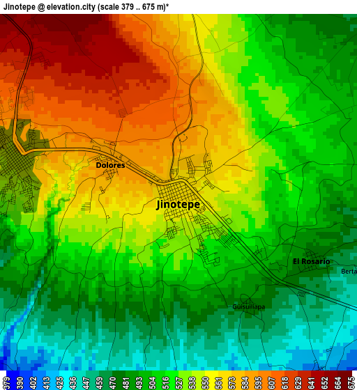
Below is the Elevation map of Jinotepe, which displays elevation range with different colors. Scale of the first map is from 379 to 675 m (1243 to 2215 ft) with average elevation of 527.9 meters (=1732 ft) [note 1]
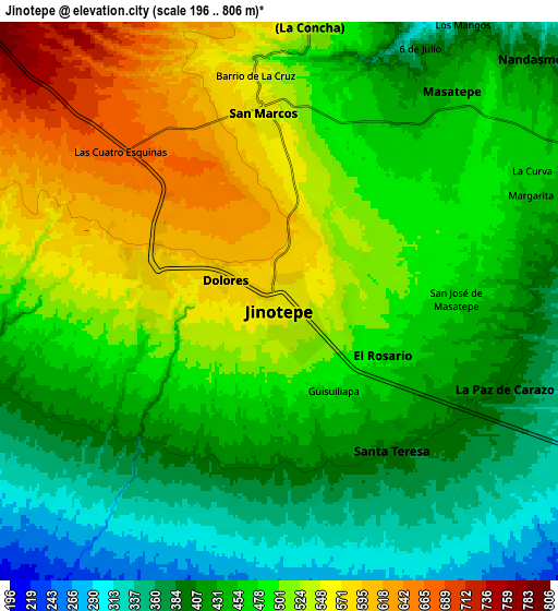
These maps also provides idea of topography and contour of this city, they are displayed at different zoom levels. More info about maps, scale and edge coordinates you can find below images.
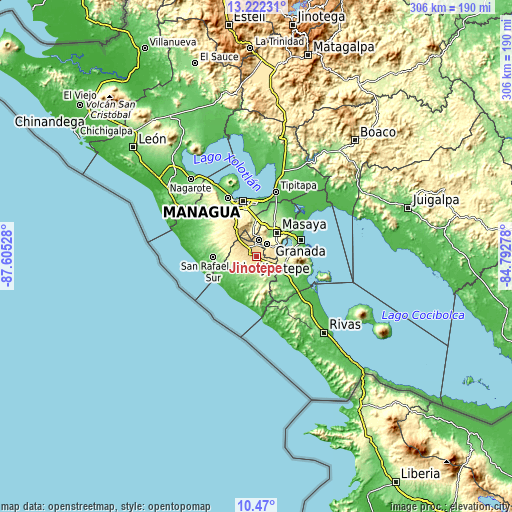
| \ | Map #1 | Map #2 | Topo.Map |
| Scale [m] | 379..675 m | 196..806 m | × |
| Scale [ft] | 1243..2215 ft | 643..2644 ft | × |
| Average | 527.9 m = 1732 ft | 470.5 m = 1544 ft | × |
| Width | 9.56 km = 5.9 mi | 19.13 km = 11.9 mi | 306 km = 190.1 mi |
| Height | 9.56 km = 5.9 mi | 19.13 km = 11.9 mi | 306.1 km = 190.2 mi |
| ↑Max Latitude | 11.892625° | 11.935624° | 13.22231° |
| Latitude at center | 11.84962° | 11.84962° | 11.84962° |
| ↓Min Latitude | 11.806608° | 11.763589° | 10.47° |
| ← Min Longitude | -86.242975° | -86.286921° | -87.60528° |
| Longitude center | -86.19903° | -86.19903° | -86.19903° |
| →Max Longitude | -86.155085° | -86.111139° | -84.79278° |
Nearby cities:
Cities around Jinotepe sort by population:
• Diriamba elevation 583 m
4.5 km,  282°
282°
• San Marcos 554 m
6.7 km,  355°
355°
• Masatepe 454 m
9.3 km,  39°
39°
• Niquinohomo 468 m
12.9 km,  61°
61°
• Dolores 585 m
2 km,  293°
293°
• La Concepción 538 m
9.8 km,  5°
5°
• Nandasmo 425 m
11.9 km,  45°
45°
• Santa Teresa 184 m
11.9 km,  187°
187°
• La Paz de Carazo 396 m
8.3 km,  110°
110°
• La Conquista 197 m
12.8 km,  176°
176°
• Santa Teresa 397 m
6.5 km,  142°
142°
• El Rosario 456 m
4.1 km,  116°
116°
Multilingual:
 En español:
Jinotepe elevación 569 m.
 En France:
Jinotepe élévation 569 m.
 Auf Deutsch:
Jinotepe höhe über dem Meeresspiegel ist 569 m.

Sources and notes:
- [note 1] Map square and city borders are not equal. Map elevation data is calculated only from area inside that square.
- [src 1] Elevation data from geonames database provided with same terms of usage.
- [src 2] The elevation map of Jinotepe is generated using elevation data from NASA's 3 arcsec (90m) resolution SRTM data.
- [src 3] Base (background) map © OpenStreetMap contributors tiles are generated by Geofabrik and OpenTopoMap.
Copyright & License:
This Jinotepe Elevation Map is licensed under CC BY-SA. You may reuse any part from this page, if you give a proper credit by linking to this URL:
 More info on terms of use page.