Hentiesbaai elevation
Hentiesbaai (Erongo), Namibia elevation is 26 meters and Hentiesbaai elevation in feet is 85 ft above sea level [src 1]. Hentiesbaai is a populated place (feature code) with elevation that is 1002 meters (3287 ft) smaller than average city elevation in Namibia.
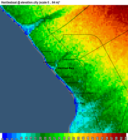
Below is the Elevation map of Hentiesbaai, which displays elevation range with different colors. Scale of the first map is from 0 to 64 m (0 to 210 ft) with average elevation of 31.6 meters (=104 ft) [note 1]
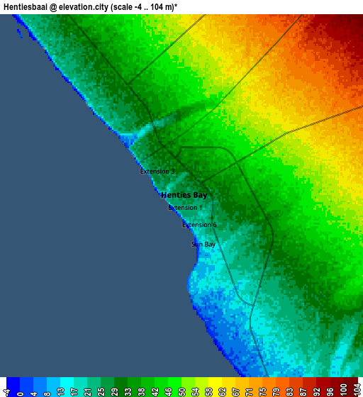
These maps also provides idea of topography and contour of this city, they are displayed at different zoom levels. More info about maps, scale and edge coordinates you can find below images.
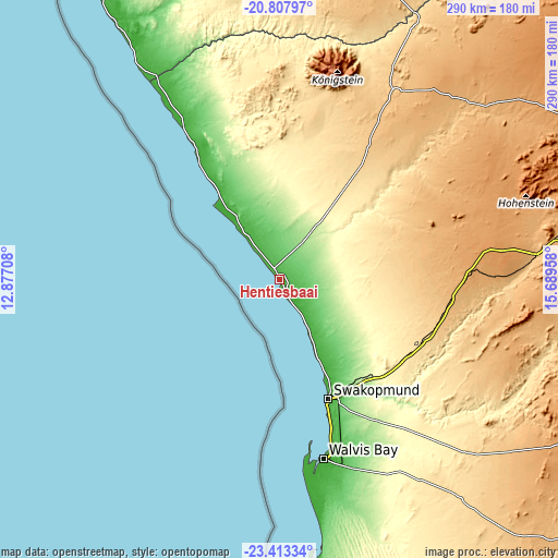
| \ | Map #1 | Map #2 | Topo.Map |
| Scale [m] | 0..64 m | -4..104 m | × |
| Scale [ft] | 0..210 ft | -13..341 ft | × |
| Average | 31.6 m = 104 ft | 42.5 m = 139 ft | × |
| Width | 9.05 km = 5.6 mi | 18.11 km = 11.3 mi | 289.7 km = 180 mi |
| Height | 9.05 km = 5.6 mi | 18.11 km = 11.3 mi | 289.7 km = 180 mi |
| ↑Max Latitude | -22.075952° | -22.035223° | -20.80797° |
| Latitude at center | -22.11667° | -22.11667° | -22.11667° |
| ↓Min Latitude | -22.157376° | -22.19807° | -23.41334° |
| ← Min Longitude | 14.239385° | 14.195439° | 12.87708° |
| Longitude center | 14.28333° | 14.28333° | 14.28333° |
| →Max Longitude | 14.327275° | 14.371221° | 15.68958° |
Nearby cities:
Cities around Hentiesbaai sort by population:
• Windhoek elevation 1656 m
292.1 km,  99°
99°
• Walvis Bay 6 m
96.2 km,  166°
166°
• Swakopmund 15 m
67.3 km,  158°
158°
• Katutura 1630 m
289.2 km, 98°
• Okahandja 1339 m
271.8 km,  86°
86°
• Khorixas 972 m
207.1 km,  19°
19°
• Omaruru 1206 m
186.5 km,  65°
65°
• Usakos 891 m
136.3 km,  84°
84°
• Otjimbingwe 895 m
192.2 km, 97°
• Karibib 1158 m
161.1 km, 82°
• Outjo 1270 m
294.8 km,  41°
41°
• Arandis 570 m
77.8 km,  115°
115°
Multilingual:
 En español:
Hentiesbaai elevación 26 m.
 En France:
Hentiesbaai élévation 26 m.
 Auf Deutsch:
Hentiesbaai höhe über dem Meeresspiegel ist 26 m.

Sources and notes:
- [note 1] Map square and city borders are not equal. Map elevation data is calculated only from area inside that square.
- [src 1] Elevation data from geonames database provided with same terms of usage.
- [src 2] The elevation map of Hentiesbaai is generated using elevation data from NASA's 3 arcsec (90m) resolution SRTM data.
- [src 3] Base (background) map © OpenStreetMap contributors tiles are generated by Geofabrik and OpenTopoMap.
Copyright & License:
This Hentiesbaai Elevation Map is licensed under CC BY-SA. You may reuse any part from this page, if you give a proper credit by linking to this URL:
 More info on terms of use page.