Putrajaya elevation
Putrajaya, Malaysia elevation is 35 meters and Putrajaya elevation in feet is 115 ft above sea level [src 1]. Putrajaya is a seat of government of a political entity (feature code) with elevation that is 10 meters (33 ft) smaller than average city elevation in Malaysia.
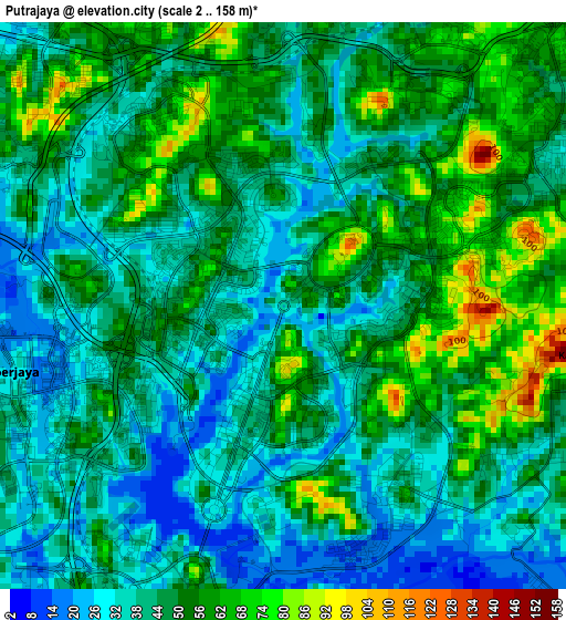
Below is the Elevation map of Putrajaya, which displays elevation range with different colors. Scale of the first map is from 2 to 158 m (7 to 518 ft) with average elevation of 46 meters (=151 ft) [note 1]
These maps also provides idea of topography and contour of this city, they are displayed at different zoom levels. More info about maps, scale and edge coordinates you can find below images.
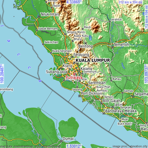
| \ | Map #1 | Map #2 | Topo.Map |
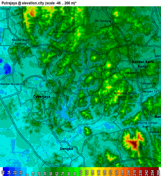
| Scale [m] | 2..158 m | -46..266 m | × |
| Scale [ft] | 7..518 ft | -151..873 ft | × |
| Average | 46 m = 151 ft | 42.4 m = 139 ft | × |
| Width | 9.76 km = 6.1 mi | 19.52 km = 12.1 mi | 312.3 km = 194.1 mi |
| Height | 9.76 km = 6.1 mi | 19.52 km = 12.1 mi | 312.3 km = 194.1 mi |
| ↑Max Latitude | 2.979157° | 3.023042° | 4.33865° |
| Latitude at center | 2.93527° | 2.93527° | 2.93527° |
| ↓Min Latitude | 2.891381° | 2.847491° | 1.53012° |
| ← Min Longitude | 101.647175° | 101.603229° | 100.28487° |
| Longitude center | 101.69112° | 101.69112° | 101.69112° |
| →Max Longitude | 101.735065° | 101.779011° | 103.09737° |
Nearby cities:
Cities around Putrajaya sort by population:
• Kuala Lumpur elevation 56 m
22.9 km,  358°
358°
• Subang Jaya 41 m
17.2 km,  314°
314°
• Petaling Jaya 45 m
21.3 km,  333°
333°
• Shah Alam 53 m
24.2 km, 313°
• Sepang 12 m
27.7 km,  166°
166°
• Ampang 56 m
25.3 km,  19°
19°
• Semenyih 39 m
17 km,  83°
83°
• Kampong Baharu Balakong 57 m
12.7 km,  30°
30°
• Putra Heights 27 m
14.7 km,  296°
296°
• Banting 9 m
25 km,  237°
237°
• Kampung Baharu Nilai 32 m
18.8 km,  141°
141°
• Jenjarum 8 m
22.9 km,  252°
252°
Multilingual:
 En español:
Putrajaya elevación 35 m.
 En France:
Putrajaya élévation 35 m.
 Auf Deutsch:
Putrajaya höhe über dem Meeresspiegel ist 35 m.

Sources and notes:
- [note 1] Map square and city borders are not equal. Map elevation data is calculated only from area inside that square.
- [src 1] Elevation data from geonames database provided with same terms of usage.
- [src 2] The elevation map of Putrajaya is generated using elevation data from NASA's 3 arcsec (90m) resolution SRTM data.
- [src 3] Base (background) map © OpenStreetMap contributors tiles are generated by Geofabrik and OpenTopoMap.
Copyright & License:
This Putrajaya Elevation Map is licensed under CC BY-SA. You may reuse any part from this page, if you give a proper credit by linking to this URL:
 More info on terms of use page.