Pantai Remis elevation
Pantai Remis (Perak), Malaysia elevation is 6 meters and Pantai Remis elevation in feet is 20 ft above sea level [src 1]. Pantai Remis is a populated place (feature code) with elevation that is 39 meters (128 ft) smaller than average city elevation in Malaysia.
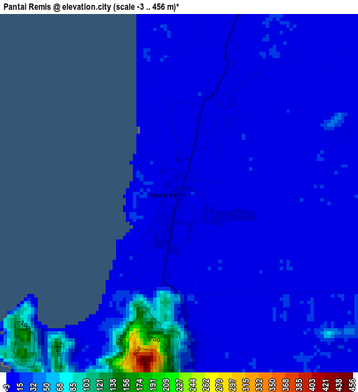
Below is the Elevation map of Pantai Remis, which displays elevation range with different colors. Scale of the first map is from -3 to 456 m (-10 to 1496 ft) with average elevation of 21.4 meters (=70 ft) [note 1]
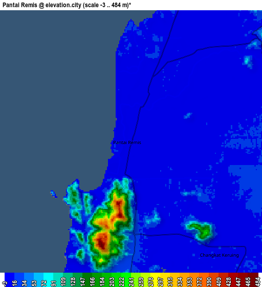
These maps also provides idea of topography and contour of this city, they are displayed at different zoom levels. More info about maps, scale and edge coordinates you can find below images.
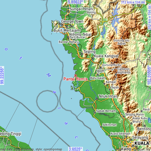
| \ | Map #1 | Map #2 | Topo.Map |
| Scale [m] | -3..456 m | -3..484 m | × |
| Scale [ft] | -10..1496 ft | -10..1588 ft | × |
| Average | 21.4 m = 70 ft | 27 m = 89 ft | × |
| Width | 9.74 km = 6.1 mi | 19.49 km = 12.1 mi | 311.7 km = 193.7 mi |
| Height | 9.74 km = 6.1 mi | 19.49 km = 12.1 mi | 311.8 km = 193.7 mi |
| ↑Max Latitude | 4.499511° | 4.54332° | 5.85622° |
| Latitude at center | 4.4557° | 4.4557° | 4.4557° |
| ↓Min Latitude | 4.411886° | 4.36807° | 3.0525° |
| ← Min Longitude | 100.584855° | 100.540909° | 99.22255° |
| Longitude center | 100.6288° | 100.6288° | 100.6288° |
| →Max Longitude | 100.672745° | 100.716691° | 102.03505° |
Nearby cities:
Cities around Pantai Remis sort by population:
• Ipoh elevation 45 m
52.3 km,  74°
74°
• Taiping 19 m
45.3 km,  14°
14°
• Teluk Intan 4 m
64.9 km,  137°
137°
• Simpang Empat 4 m
55 km,  0°
0°
• Batu Gajah 31 m
45.7 km,  88°
88°
• Nibong Tebal 5 m
80.7 km,  348°
348°
• Lumut 13 m
24.8 km,  179°
179°
• Kuala Kangsar 42 m
48.3 km,  44°
44°
• Tapah Road 40 m
71 km,  116°
116°
• Parit Buntar 5 m
76.1 km, 348°
• Bagan Serai 3 m
62.5 km, 351°
• Kampar 25 m
60.3 km,  106°
106°
Multilingual:
 En español:
Pantai Remis elevación 6 m.
 En France:
Pantai Remis élévation 6 m.
 Auf Deutsch:
Pantai Remis höhe über dem Meeresspiegel ist 6 m.

Sources and notes:
- [note 1] Map square and city borders are not equal. Map elevation data is calculated only from area inside that square.
- [src 1] Elevation data from geonames database provided with same terms of usage.
- [src 2] The elevation map of Pantai Remis is generated using elevation data from NASA's 3 arcsec (90m) resolution SRTM data.
- [src 3] Base (background) map © OpenStreetMap contributors tiles are generated by Geofabrik and OpenTopoMap.
Copyright & License:
This Pantai Remis Elevation Map is licensed under CC BY-SA. You may reuse any part from this page, if you give a proper credit by linking to this URL:
 More info on terms of use page.