Kuantan elevation
Kuantan (Pahang), Malaysia elevation is 12 meters and Kuantan elevation in feet is 39 ft above sea level [src 1]. Kuantan is a seat of a first-order administrative division (feature code) with elevation that is 33 meters (108 ft) smaller than average city elevation in Malaysia.
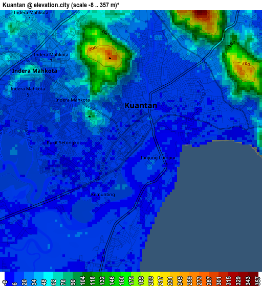
Below is the Elevation map of Kuantan, which displays elevation range with different colors. Scale of the first map is from -8 to 357 m (-26 to 1171 ft) with average elevation of 32.6 meters (=107 ft) [note 1]
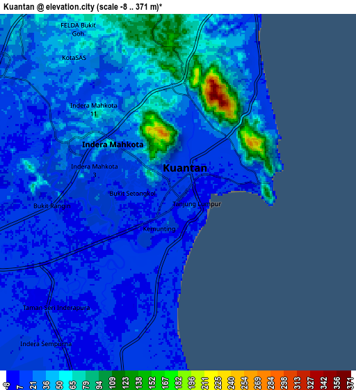
These maps also provides idea of topography and contour of this city, they are displayed at different zoom levels. More info about maps, scale and edge coordinates you can find below images.
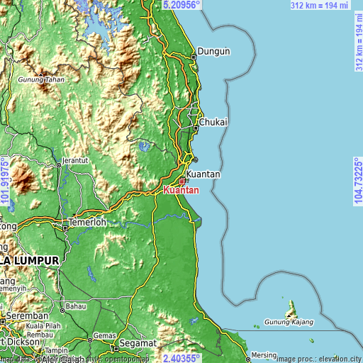
| \ | Map #1 | Map #2 | Topo.Map |
| Scale [m] | -8..357 m | -8..371 m | × |
| Scale [ft] | -26..1171 ft | -26..1217 ft | × |
| Average | 32.6 m = 107 ft | 29.8 m = 98 ft | × |
| Width | 9.75 km = 6.1 mi | 19.5 km = 12.1 mi | 312 km = 193.9 mi |
| Height | 9.75 km = 6.1 mi | 19.5 km = 12.1 mi | 312 km = 193.9 mi |
| ↑Max Latitude | 3.851547° | 3.895392° | 5.20956° |
| Latitude at center | 3.8077° | 3.8077° | 3.8077° |
| ↓Min Latitude | 3.763851° | 3.719999° | 2.40355° |
| ← Min Longitude | 103.282055° | 103.238109° | 101.91975° |
| Longitude center | 103.326° | 103.326° | 103.326° |
| →Max Longitude | 103.369945° | 103.413891° | 104.73225° |
Nearby cities:
Cities around Kuantan sort by population:
• Cukai elevation 12 m
50.2 km,  11°
11°
• Segamat 35 m
154.5 km,  201°
201°
• Temerluh 45 m
108.3 km,  248°
248°
• Mentekab 43 m
114.2 km, 251°
• Jerantut 73 m
107.8 km,  277°
277°
• Pekan 11 m
37 km,  167°
167°
• Bahau 63 m
151 km,  222°
222°
• Kertih 5 m
79.7 km, 9°
• Paka 9 m
93.1 km, 7°
• Kuala Lipis 99 m
147.9 km,  286°
286°
• Buloh Kasap 20 m
152.8 km, 204°
• Kampung Tekek 14 m
144 km,  140°
140°
Multilingual:
 En español:
Kuantan elevación 12 m.
 En France:
Kuantan élévation 12 m.


Sources and notes:
- [note 1] Map square and city borders are not equal. Map elevation data is calculated only from area inside that square.
- [src 1] Elevation data from geonames database provided with same terms of usage.
- [src 2] The elevation map of Kuantan is generated using elevation data from NASA's 3 arcsec (90m) resolution SRTM data.
- [src 3] Base (background) map © OpenStreetMap contributors tiles are generated by Geofabrik and OpenTopoMap.
Copyright & License:
This Kuantan Elevation Map is licensed under CC BY-SA. You may reuse any part from this page, if you give a proper credit by linking to this URL:
 More info on terms of use page.