Batu Feringgi elevation
Batu Feringgi (Penang), Malaysia elevation is 9 meters and Batu Feringgi elevation in feet is 30 ft above sea level [src 1]. Batu Feringgi is a populated place (feature code) with elevation that is 36 meters (118 ft) smaller than average city elevation in Malaysia.
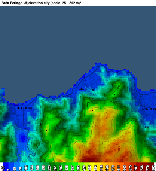
Below is the Elevation map of Batu Feringgi, which displays elevation range with different colors. Scale of the first map is from -25 to 802 m (-82 to 2631 ft) with average elevation of 246.5 meters (=809 ft) [note 1]
These maps also provides idea of topography and contour of this city, they are displayed at different zoom levels. More info about maps, scale and edge coordinates you can find below images.
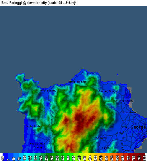
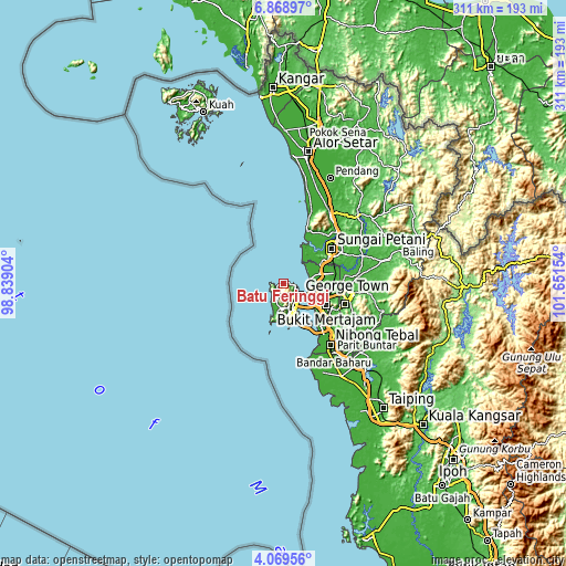
| \ | Map #1 | Map #2 | Topo.Map |
| Scale [m] | -25..802 m | -25..818 m | × |
| Scale [ft] | -82..2631 ft | -82..2684 ft | × |
| Average | 246.5 m = 809 ft | 208.7 m = 685 ft | × |
| Width | 9.73 km = 6 mi | 19.46 km = 12.1 mi | 311.3 km = 193.4 mi |
| Height | 9.73 km = 6 mi | 19.46 km = 12.1 mi | 311.3 km = 193.4 mi |
| ↑Max Latitude | 5.514644° | 5.558384° | 6.86897° |
| Latitude at center | 5.4709° | 5.4709° | 5.4709° |
| ↓Min Latitude | 5.427153° | 5.383403° | 4.06956° |
| ← Min Longitude | 100.201345° | 100.157399° | 98.83904° |
| Longitude center | 100.24529° | 100.24529° | 100.24529° |
| →Max Longitude | 100.289235° | 100.333181° | 101.65154° |
Nearby cities:
Cities around Batu Feringgi sort by population:
• George Town elevation 14 m
12 km,  123°
123°
• Bukit Mertajam 27 m
27.3 km, 116°
• Kampung Sungai Ara 21 m
16.3 km,  168°
168°
• Tasek Glugor 10 m
28 km,  87°
87°
• Butterworth 6 m
15.4 km, 121°
• Perai 5 m
18.1 km, 122°
• Permatang Kuching 10 m
15.1 km, 93°
• Tanjung Tokong 10 m
7 km,  99°
99°
• Kepala Batas 8 m
20.7 km,  75°
75°
• Juru 10 m
28.1 km,  129°
129°
• Telaga Batu 70 m
1.4 km,  250°
250°
• Kampung Batu Feringgi 7 m
0.2 km,  209°
209°
Multilingual:
 En español:
Batu Feringgi elevación 9 m.
 En France:
Batu Feringgi élévation 9 m.
 Auf Deutsch:
Batu Feringgi höhe über dem Meeresspiegel ist 9 m.

Sources and notes:
- [note 1] Map square and city borders are not equal. Map elevation data is calculated only from area inside that square.
- [src 1] Elevation data from geonames database provided with same terms of usage.
- [src 2] The elevation map of Batu Feringgi is generated using elevation data from NASA's 3 arcsec (90m) resolution SRTM data.
- [src 3] Base (background) map © OpenStreetMap contributors tiles are generated by Geofabrik and OpenTopoMap.
Copyright & License:
This Batu Feringgi Elevation Map is licensed under CC BY-SA. You may reuse any part from this page, if you give a proper credit by linking to this URL:
 More info on terms of use page.