Gua Musang elevation
Gua Musang (Kelantan), Malaysia elevation is 90 meters and Gua Musang elevation in feet is 295 ft above sea level [src 1]. Gua Musang is a populated place (feature code) with elevation that is 45 meters (148 ft) bigger than average city elevation in Malaysia.
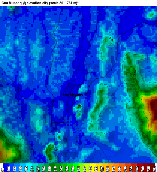
Below is the Elevation map of Gua Musang, which displays elevation range with different colors. Scale of the first map is from 80 to 761 m (262 to 2497 ft) with average elevation of 158.4 meters (=520 ft) [note 1]
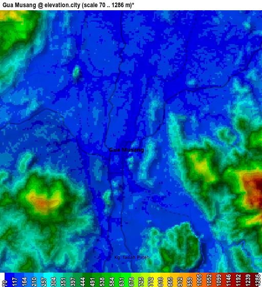
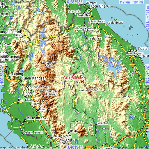
These maps also provides idea of topography and contour of this city, they are displayed at different zoom levels. More info about maps, scale and edge coordinates you can find below images.
| \ | Map #1 | Map #2 | Topo.Map |
| Scale [m] | 80..761 m | 70..1286 m | × |
| Scale [ft] | 262..2497 ft | 230..4219 ft | × |
| Average | 158.4 m = 520 ft | 233 m = 764 ft | × |
| Width | 9.74 km = 6.1 mi | 19.47 km = 12.1 mi | 311.6 km = 193.6 mi |
| Height | 9.74 km = 6.1 mi | 19.47 km = 12.1 mi | 311.6 km = 193.6 mi |
| ↑Max Latitude | 4.928194° | 4.971976° | 6.28395° |
| Latitude at center | 4.88441° | 4.88441° | 4.88441° |
| ↓Min Latitude | 4.840623° | 4.796833° | 3.48194° |
| ← Min Longitude | 101.924625° | 101.880679° | 100.56232° |
| Longitude center | 101.96857° | 101.96857° | 101.96857° |
| →Max Longitude | 102.012515° | 102.056461° | 103.37482° |
Nearby cities:
Cities around Gua Musang sort by population:
• Ipoh elevation 45 m
103.7 km,  251°
251°
• Batu Gajah 31 m
112.7 km, 245°
• Kuala Kangsar 42 m
115.4 km,  263°
263°
• Jerantut 73 m
114.1 km,  157°
157°
• Bidur 39 m
114.3 km,  221°
221°
• Tanah Merah 19 m
103.8 km,  11°
11°
• Tapah Road 40 m
116.7 km,  226°
226°
• Kampar 25 m
111.6 km, 234°
• Kuala Lipis 99 m
78.3 km,  173°
173°
• Jertih 16 m
110.7 km,  31°
31°
• Tanah Rata 1488 m
80.6 km, 234°
• Pulai Chondong 31 m
113.5 km, 14°
Multilingual:
 En español:
Gua Musang elevación 90 m.
 En France:
Gua Musang élévation 90 m.
 Auf Deutsch:
Gua Musang höhe über dem Meeresspiegel ist 90 m.

Sources and notes:
- [note 1] Map square and city borders are not equal. Map elevation data is calculated only from area inside that square.
- [src 1] Elevation data from geonames database provided with same terms of usage.
- [src 2] The elevation map of Gua Musang is generated using elevation data from NASA's 3 arcsec (90m) resolution SRTM data.
- [src 3] Base (background) map © OpenStreetMap contributors tiles are generated by Geofabrik and OpenTopoMap.
Copyright & License:
This Gua Musang Elevation Map is licensed under CC BY-SA. You may reuse any part from this page, if you give a proper credit by linking to this URL:
 More info on terms of use page.