Johor Bahru elevation
Johor Bahru (Johor), Malaysia elevation is 32 meters and Johor Bahru elevation in feet is 105 ft above sea level [src 1]. Johor Bahru is a seat of a first-order administrative division (feature code) with elevation that is 13 meters (43 ft) smaller than average city elevation in Malaysia.
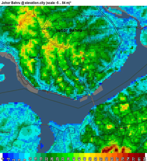
Below is the Elevation map of Johor Bahru, which displays elevation range with different colors. Scale of the first map is from -5 to 84 m (-16 to 276 ft) with average elevation of 23.3 meters (=76 ft) [note 1]
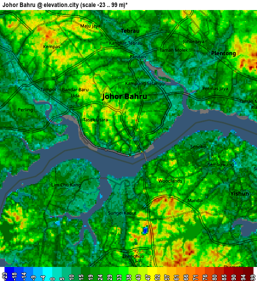
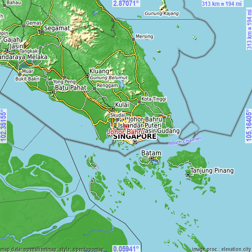
These maps also provides idea of topography and contour of this city, they are displayed at different zoom levels. More info about maps, scale and edge coordinates you can find below images.
| \ | Map #1 | Map #2 | Topo.Map |
| Scale [m] | -5..84 m | -23..99 m | × |
| Scale [ft] | -16..276 ft | -75..325 ft | × |
| Average | 23.3 m = 76 ft | 24.5 m = 80 ft | × |
| Width | 9.77 km = 6.1 mi | 19.54 km = 12.1 mi | 312.6 km = 194.2 mi |
| Height | 9.77 km = 6.1 mi | 19.54 km = 12.1 mi | 312.6 km = 194.2 mi |
| ↑Max Latitude | 1.509431° | 1.55336° | 2.87071° |
| Latitude at center | 1.4655° | 1.4655° | 1.4655° |
| ↓Min Latitude | 1.421569° | 1.377636° | 0.05941° |
| ← Min Longitude | 103.713855° | 103.669909° | 102.35155° |
| Longitude center | 103.7578° | 103.7578° | 103.7578° |
| →Max Longitude | 103.801745° | 103.845691° | 105.16405° |
Nearby cities:
Cities around Johor Bahru sort by population:
• Kluang elevation 51 m
79.7 km,  322°
322°
• Skudai 40 m
13.7 km,  305°
305°
• Kampung Pasir Gudang Baru 10 m
13.4 km,  86°
86°
• Ulu Tiram 28 m
16.3 km,  23°
23°
• Taman Senai 26 m
19.8 km, 319°
• Kulai 33 m
27.3 km, 320°
• Kota Tinggi 17 m
34.2 km,  27°
27°
• Pontian Kechil 11 m
41 km,  273°
273°
• Pekan Nenas 20 m
27.5 km,  280°
280°
• Kampung Simpang Renggam 16 m
64.9 km, 308°
• Parit Raja 9 m
84.6 km,  301°
301°
• Kelapa Sawit 24 m
33.8 km, 312°
Multilingual:
 En español:
Johor Bahru elevación 32 m.
 En France:
Johor Bahru élévation 32 m.
 Auf Deutsch:
Johor Bahru höhe über dem Meeresspiegel ist 32 m.

Sources and notes:
- [note 1] Map square and city borders are not equal. Map elevation data is calculated only from area inside that square.
- [src 1] Elevation data from geonames database provided with same terms of usage.
- [src 2] The elevation map of Johor Bahru is generated using elevation data from NASA's 3 arcsec (90m) resolution SRTM data.
- [src 3] Base (background) map © OpenStreetMap contributors tiles are generated by Geofabrik and OpenTopoMap.
Copyright & License:
This Johor Bahru Elevation Map is licensed under CC BY-SA. You may reuse any part from this page, if you give a proper credit by linking to this URL:
 More info on terms of use page.