Raub elevation
Raub (Pahang), Malaysia elevation is 149 meters and Raub elevation in feet is 489 ft above sea level [src 1]. Raub is a populated place (feature code) with elevation that is 104 meters (341 ft) bigger than average city elevation in Malaysia.
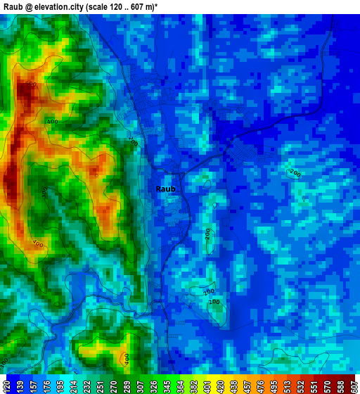
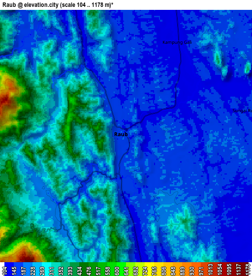
Below is the Elevation map of Raub, which displays elevation range with different colors. Scale of the first map is from 120 to 607 m (394 to 1991 ft) with average elevation of 218.6 meters (=717 ft) [note 1]
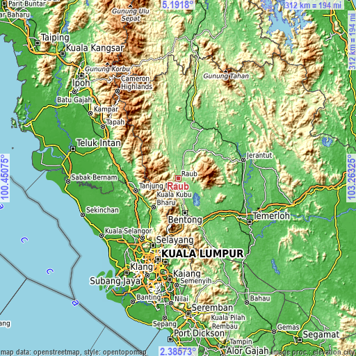
These maps also provides idea of topography and contour of this city, they are displayed at different zoom levels. More info about maps, scale and edge coordinates you can find below images.
| \ | Map #1 | Map #2 | Topo.Map |
| Scale [m] | 120..607 m | 104..1178 m | × |
| Scale [ft] | 394..1991 ft | 341..3865 ft | × |
| Average | 218.6 m = 717 ft | 242.9 m = 797 ft | × |
| Width | 9.75 km = 6.1 mi | 19.5 km = 12.1 mi | 312 km = 193.9 mi |
| Height | 9.75 km = 6.1 mi | 19.5 km = 12.1 mi | 312 km = 193.9 mi |
| ↑Max Latitude | 3.833748° | 3.877594° | 5.1918° |
| Latitude at center | 3.7899° | 3.7899° | 3.7899° |
| ↓Min Latitude | 3.74605° | 3.702197° | 2.38573° |
| ← Min Longitude | 101.813055° | 101.769109° | 100.45075° |
| Longitude center | 101.857° | 101.857° | 101.857° |
| →Max Longitude | 101.900945° | 101.944891° | 103.26325° |
Nearby cities:
Cities around Raub sort by population:
• Ampang elevation 56 m
71.9 km,  188°
188°
• Rawang 38 m
60.7 km,  210°
210°
• Bentong Town 95 m
30.3 km,  169°
169°
• Mentekab 43 m
64.2 km,  121°
121°
• Jerantut 73 m
58.4 km,  73°
73°
• Serendah 42 m
55 km, 210°
• Ladang Seri Kundang 25 m
67.5 km, 213°
• Batu Arang 61 m
68.2 km,  219°
219°
• Kuang 46 m
67.9 km, 209°
• Batang Berjuntai 35 m
66.6 km,  227°
227°
• Kuala Lipis 99 m
48.6 km,  25°
25°
• Kampung Bukit Tinggi, Bentong 390 m
49.1 km,  183°
183°
Multilingual:
 En español:
Raub elevación 149 m.
 En France:
Raub élévation 149 m.


Sources and notes:
- [note 1] Map square and city borders are not equal. Map elevation data is calculated only from area inside that square.
- [src 1] Elevation data from geonames database provided with same terms of usage.
- [src 2] The elevation map of Raub is generated using elevation data from NASA's 3 arcsec (90m) resolution SRTM data.
- [src 3] Base (background) map © OpenStreetMap contributors tiles are generated by Geofabrik and OpenTopoMap.
Copyright & License:
This Raub Elevation Map is licensed under CC BY-SA. You may reuse any part from this page, if you give a proper credit by linking to this URL:
 More info on terms of use page.