Mzuzu elevation
Mzuzu (Northern Region, Mzimba District), Malawi elevation is 1275 meters and Mzuzu elevation in feet is 4183 ft above sea level [src 1]. Mzuzu is a seat of a first-order administrative division (feature code) with elevation that is 406 meters (1332 ft) bigger than average city elevation in Malawi.
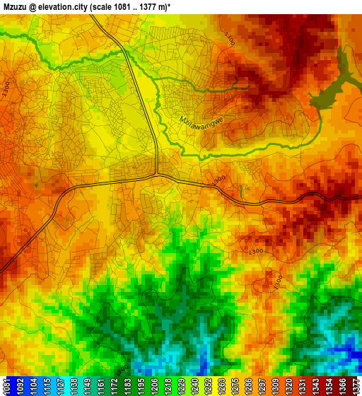
Below is the Elevation map of Mzuzu, which displays elevation range with different colors. Scale of the first map is from 1081 to 1377 m (3547 to 4518 ft) with average elevation of 1267.1 meters (=4157 ft) [note 1]
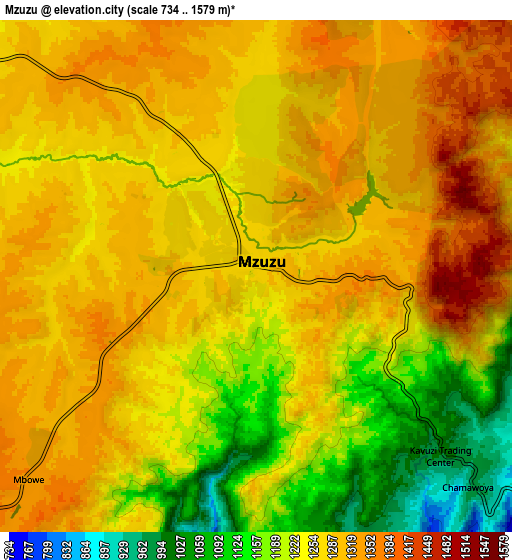
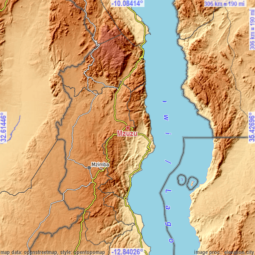
These maps also provides idea of topography and contour of this city, they are displayed at different zoom levels. More info about maps, scale and edge coordinates you can find below images.
| \ | Map #1 | Map #2 | Topo.Map |
| Scale [m] | 1081..1377 m | 734..1579 m | × |
| Scale [ft] | 3547..4518 ft | 2408..5180 ft | × |
| Average | 1267.1 m = 4157 ft | 1258.9 m = 4130 ft | × |
| Width | 9.58 km = 6 mi | 19.16 km = 11.9 mi | 306.5 km = 190.4 mi |
| Height | 9.58 km = 6 mi | 19.16 km = 11.9 mi | 306.5 km = 190.4 mi |
| ↑Max Latitude | -11.422488° | -11.37941° | -10.08414° |
| Latitude at center | -11.46556° | -11.46556° | -11.46556° |
| ↓Min Latitude | -11.508625° | -11.551684° | -12.84026° |
| ← Min Longitude | 33.976765° | 33.932819° | 32.61446° |
| Longitude center | 34.02071° | 34.02071° | 34.02071° |
| →Max Longitude | 34.064655° | 34.108601° | 35.42696° |
Nearby cities:
Cities around Mzuzu sort by population:
• Kasungu elevation 1051 m
183.8 km,  198°
198°
• Karonga 486 m
170.6 km,  356°
356°
• Nkhotakota 497 m
165.3 km,  169°
169°
• Rumphi 1084 m
52.8 km,  340°
340°
• Mzimba 1339 m
66.6 km,  223°
223°
• Nkhata Bay 547 m
33.3 km,  118°
118°
• Mponela 1216 m
231.8 km,  187°
187°
• Chitipa 1286 m
212.5 km, 337°
• Ntchisi 1545 m
229.6 km,  182°
182°
• Dowa 1361 m
243.5 km, 182°
• Livingstonia 1350 m
96 km,  5°
5°
• Likoma 506 m
102.4 km,  130°
130°
Multilingual:
 En español:
Mzuzu elevación 1275 m.
 En France:
Mzuzu élévation 1275 m.


Sources and notes:
- [note 1] Map square and city borders are not equal. Map elevation data is calculated only from area inside that square.
- [src 1] Elevation data from geonames database provided with same terms of usage.
- [src 2] The elevation map of Mzuzu is generated using elevation data from NASA's 3 arcsec (90m) resolution SRTM data.
- [src 3] Base (background) map © OpenStreetMap contributors tiles are generated by Geofabrik and OpenTopoMap.
Copyright & License:
This Mzuzu Elevation Map is licensed under CC BY-SA. You may reuse any part from this page, if you give a proper credit by linking to this URL:
 More info on terms of use page.