Pointe aux Piments elevation
Pointe aux Piments (Pamplemousses), Mauritius elevation is 143 meters and Pointe aux Piments elevation in feet is 469 ft above sea level [src 1]. Pointe aux Piments is a populated place (feature code) with elevation that is 6 meters (20 ft) smaller than average city elevation in Mauritius.
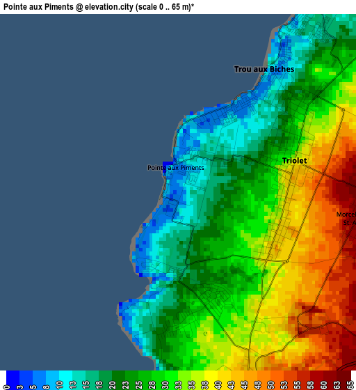
Below is the Elevation map of Pointe aux Piments, which displays elevation range with different colors. Scale of the first map is from 0 to 65 m (0 to 213 ft) with average elevation of 29.7 meters (=97 ft) [note 1]
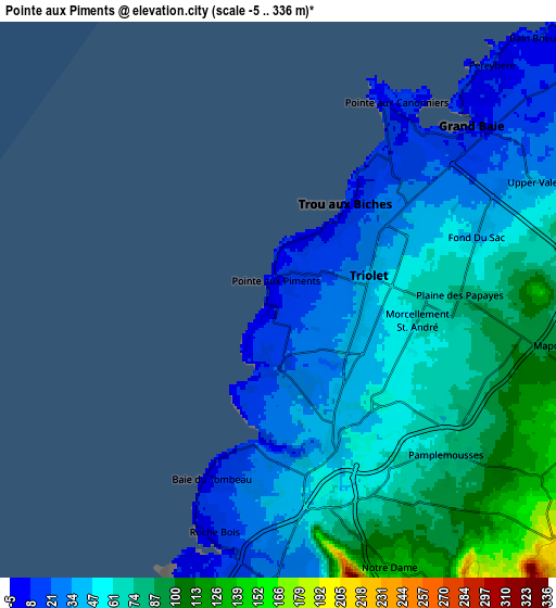
These maps also provides idea of topography and contour of this city, they are displayed at different zoom levels. More info about maps, scale and edge coordinates you can find below images.
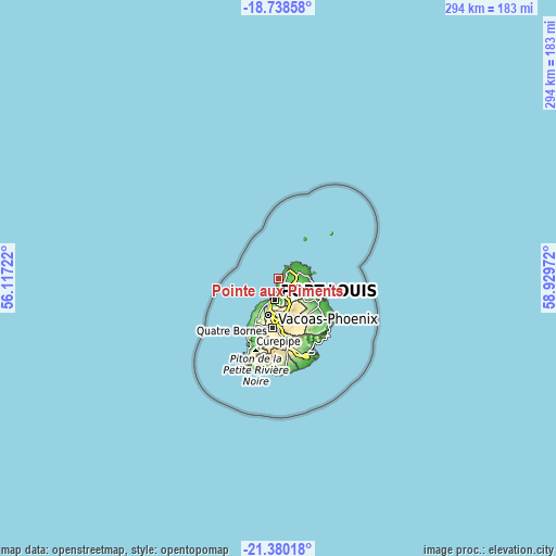
| \ | Map #1 | Map #2 | Topo.Map |
| Scale [m] | 0..65 m | -5..336 m | × |
| Scale [ft] | 0..213 ft | -16..1102 ft | × |
| Average | 29.7 m = 97 ft | 56.7 m = 186 ft | × |
| Width | 9.18 km = 5.7 mi | 18.36 km = 11.4 mi | 293.7 km = 182.5 mi |
| Height | 9.18 km = 5.7 mi | 18.36 km = 11.4 mi | 293.7 km = 182.5 mi |
| ↑Max Latitude | -20.023657° | -19.982362° | -18.73858° |
| Latitude at center | -20.06494° | -20.06494° | -20.06494° |
| ↓Min Latitude | -20.106213° | -20.147474° | -21.38018° |
| ← Min Longitude | 57.479525° | 57.435579° | 56.11722° |
| Longitude center | 57.52347° | 57.52347° | 57.52347° |
| →Max Longitude | 57.567415° | 57.611361° | 58.92972° |
Nearby cities:
Cities around Pointe aux Piments sort by population:
• Triolet elevation 135 m
2.9 km,  73°
73°
• Le Hochet 30 m
7.8 km,  181°
181°
• Grand Baie 10 m
7.9 km,  48°
48°
• Terre Rouge 40 m
6.8 km, 179°
• Pamplemousses 64 m
6.5 km,  131°
131°
• Plaine des Papayes 68 m
5.1 km,  90°
90°
• Morcellement Saint André 147 m
4.8 km,  99°
99°
• Fond du Sac 142 m
6.6 km, 72°
• Calebasses 55 m
6.1 km,  148°
148°
• Notre Dame 111 m
9 km,  159°
159°
• Arsenal 40 m
4.7 km, 164°
• Mapou 91 m
8.2 km, 98°
Multilingual:
 En español:
Pointe aux Piments elevación 143 m.
 En France:
Pointe aux Piments élévation 143 m.
 Auf Deutsch:
Pointe aux Piments höhe über dem Meeresspiegel ist 143 m.
 На русском:
Pointe aux Piments высота над уровнем моря 143 м
Sources and notes:
- [note 1] Map square and city borders are not equal. Map elevation data is calculated only from area inside that square.
- [src 1] Elevation data from geonames database provided with same terms of usage.
- [src 2] The elevation map of Pointe aux Piments is generated using elevation data from NASA's 3 arcsec (90m) resolution SRTM data.
- [src 3] Base (background) map © OpenStreetMap contributors tiles are generated by Geofabrik and OpenTopoMap.
Copyright & License:
This Pointe aux Piments Elevation Map is licensed under CC BY-SA. You may reuse any part from this page, if you give a proper credit by linking to this URL:
 More info on terms of use page.