Santa Luċija elevation
Santa Luċija (Saint Lucia), Malta elevation is 58 meters and Santa Luċija elevation in feet is 190 ft above sea level [src 1]. Santa Luċija is a section of populated place (feature code) with elevation that is 20 meters (66 ft) smaller than average city elevation in Malta.
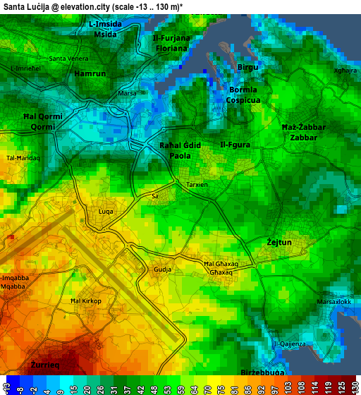
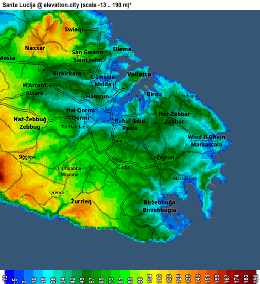
Below is the Elevation map of Santa Luċija, which displays elevation range with different colors. Scale of the first map is from -13 to 130 m (-43 to 427 ft) with average elevation of 50.5 meters (=166 ft) [note 1]
These maps also provides idea of topography and contour of this city, they are displayed at different zoom levels. More info about maps, scale and edge coordinates you can find below images.
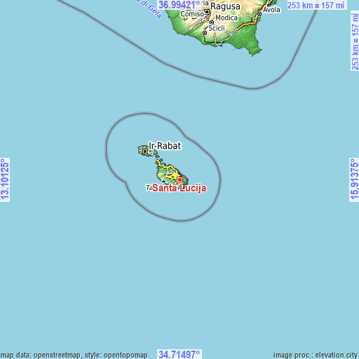
| \ | Map #1 | Map #2 | Topo.Map |
| Scale [m] | -13..130 m | -13..190 m | × |
| Scale [ft] | -43..427 ft | -43..623 ft | × |
| Average | 50.5 m = 166 ft | 63.6 m = 209 ft | × |
| Width | 7.92 km = 4.9 mi | 15.84 km = 9.8 mi | 253.4 km = 157.5 mi |
| Height | 7.92 km = 4.9 mi | 15.84 km = 9.8 mi | 253.4 km = 157.5 mi |
| ↑Max Latitude | 35.898386° | 35.933977° | 36.99421° |
| Latitude at center | 35.86278° | 35.86278° | 35.86278° |
| ↓Min Latitude | 35.827158° | 35.791519° | 34.71497° |
| ← Min Longitude | 14.463555° | 14.419609° | 13.10125° |
| Longitude center | 14.5075° | 14.5075° | 14.5075° |
| →Max Longitude | 14.551445° | 14.595391° | 15.91375° |
Nearby cities:
Cities around Santa Luċija sort by population:
• Żabbar elevation 47 m
2.9 km,  59°
59°
• Fgura 64 m
1 km,  32°
32°
• Żejtun 56 m
2.4 km,  108°
108°
• Paola 9 m
1.4 km,  325°
325°
• Tarxien 62 m
0.8 km, 63°
• Cospicua 39 m
3.1 km,  35°
35°
• Marsa 8 m
2.1 km, 328°
• Luqa 79 m
1.8 km,  255°
255°
• Għaxaq 73 m
1.8 km,  151°
151°
• Gudja 79 m
1.6 km,  194°
194°
• Senglea 18 m
2.9 km,  17°
17°
• Kirkop 82 m
3 km,  221°
221°
Multilingual:
 En español:
Santa Luċija elevación 58 m.
 En France:
Santa Luċija élévation 58 m.
 Auf Deutsch:
Santa Luċija höhe über dem Meeresspiegel ist 58 m.

Sources and notes:
- [note 1] Map square and city borders are not equal. Map elevation data is calculated only from area inside that square.
- [src 1] Elevation data from geonames database provided with same terms of usage.
- [src 2] The elevation map of Santa Luċija is generated using elevation data from NASA's 3 arcsec (90m) resolution SRTM data.
- [src 3] Base (background) map © OpenStreetMap contributors tiles are generated by Geofabrik and OpenTopoMap.
Copyright & License:
This Santa Luċija Elevation Map is licensed under CC BY-SA. You may reuse any part from this page, if you give a proper credit by linking to this URL:
 More info on terms of use page.