Valletta elevation
Valletta (Il-Belt Valletta), Malta elevation is 44 meters and Valletta elevation in feet is 144 ft above sea level [src 1]. Valletta is a capital of a political entity (feature code) with elevation that is 34 meters (112 ft) smaller than average city elevation in Malta.
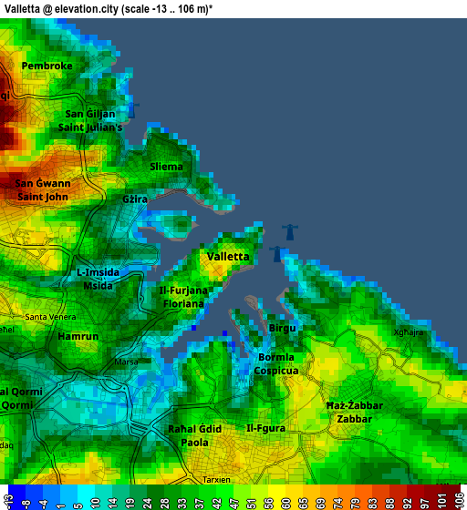
Below is the Elevation map of Valletta, which displays elevation range with different colors. Scale of the first map is from -13 to 106 m (-43 to 348 ft) with average elevation of 36.3 meters (=119 ft) [note 1]
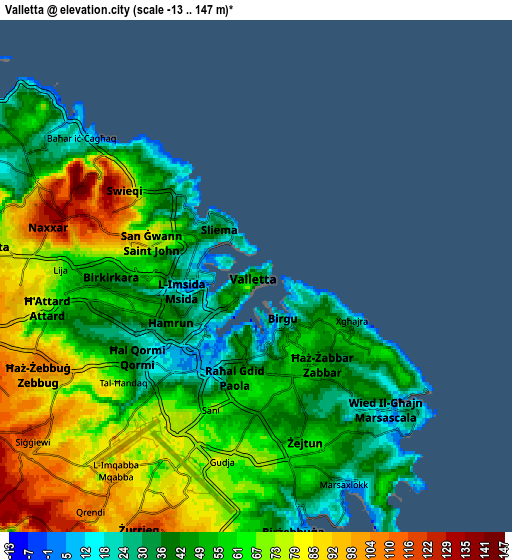
These maps also provides idea of topography and contour of this city, they are displayed at different zoom levels. More info about maps, scale and edge coordinates you can find below images.
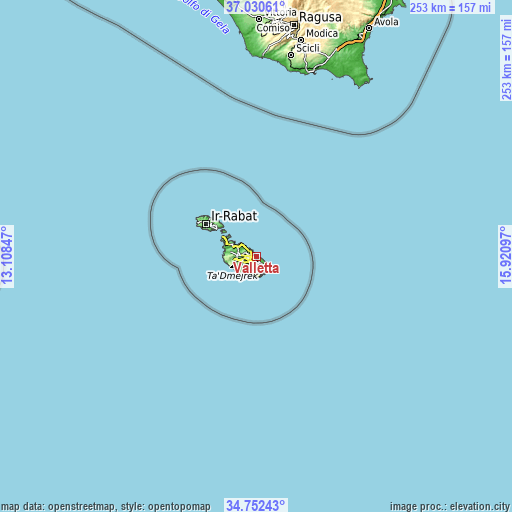
| \ | Map #1 | Map #2 | Topo.Map |
| Scale [m] | -13..106 m | -13..147 m | × |
| Scale [ft] | -43..348 ft | -43..482 ft | × |
| Average | 36.3 m = 119 ft | 60 m = 197 ft | × |
| Width | 7.92 km = 4.9 mi | 15.83 km = 9.8 mi | 253.3 km = 157.4 mi |
| Height | 7.92 km = 4.9 mi | 15.83 km = 9.8 mi | 253.3 km = 157.4 mi |
| ↑Max Latitude | 35.93531° | 35.970883° | 37.03061° |
| Latitude at center | 35.89972° | 35.89972° | 35.89972° |
| ↓Min Latitude | 35.864114° | 35.828493° | 34.75243° |
| ← Min Longitude | 14.470775° | 14.426829° | 13.10847° |
| Longitude center | 14.51472° | 14.51472° | 14.51472° |
| →Max Longitude | 14.558665° | 14.602611° | 15.92097° |
Nearby cities:
Cities around Valletta sort by population:
• Sliema elevation 40 m
1.8 km,  320°
320°
• Gżira 31 m
2.5 km,  285°
285°
• Imsida 39 m
3 km,  254°
254°
• San Ġiljan 19 m
3.1 km,  312°
312°
• Cospicua 39 m
2 km,  143°
143°
• Marsa 8 m
2.9 km,  217°
217°
• Pietà 30 m
1.9 km, 252°
• Kalkara 34 m
2 km,  125°
125°
• Senglea 18 m
1.4 km,  171°
171°
• Vittoriosa 5 m
0.9 km,  158°
158°
• Floriana 47 m
0.7 km,  233°
233°
• Ta’ Xbiex 21 m
1.8 km,  268°
268°
Multilingual:
 En español:
Valletta, La Valeta elevación 44 m.
 En France:
La Valette élévation 44 m.


Sources and notes:
- [note 1] Map square and city borders are not equal. Map elevation data is calculated only from area inside that square.
- [src 1] Elevation data from geonames database provided with same terms of usage.
- [src 2] The elevation map of Valletta is generated using elevation data from NASA's 3 arcsec (90m) resolution SRTM data.
- [src 3] Base (background) map © OpenStreetMap contributors tiles are generated by Geofabrik and OpenTopoMap.
Copyright & License:
This Valletta Elevation Map is licensed under CC BY-SA. You may reuse any part from this page, if you give a proper credit by linking to this URL:
 More info on terms of use page.