Kaédi elevation
Kaédi (Gorgol), Mauritania elevation is 25 meters and Kaédi elevation in feet is 82 ft above sea level [src 1]. Kaédi is a seat of a first-order administrative division (feature code) with elevation that is 101 meters (331 ft) smaller than average city elevation in Mauritania.
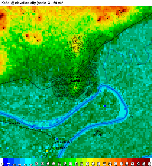
Below is the Elevation map of Kaédi, which displays elevation range with different colors. Scale of the first map is from -3 to 60 m (-10 to 197 ft) with average elevation of 18.6 meters (=61 ft) [note 1]
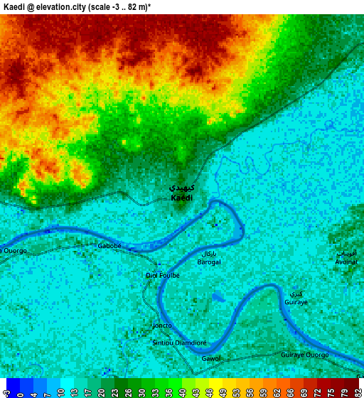
These maps also provides idea of topography and contour of this city, they are displayed at different zoom levels. More info about maps, scale and edge coordinates you can find below images.
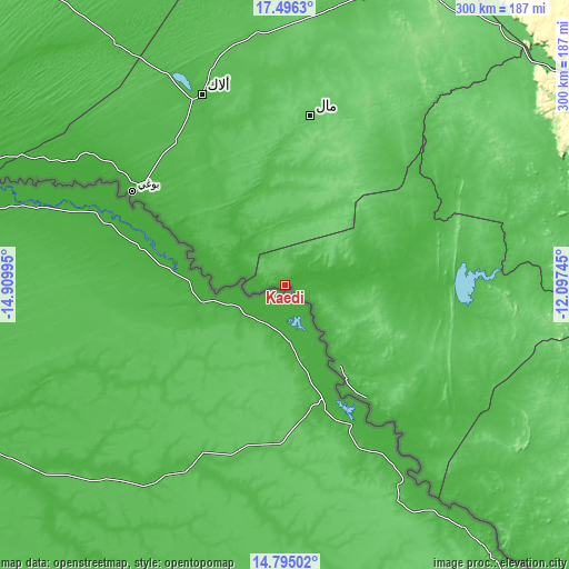
| \ | Map #1 | Map #2 | Topo.Map |
| Scale [m] | -3..60 m | -3..82 m | × |
| Scale [ft] | -10..197 ft | -10..269 ft | × |
| Average | 18.6 m = 61 ft | 26.5 m = 87 ft | × |
| Width | 9.39 km = 5.8 mi | 18.77 km = 11.7 mi | 300.4 km = 186.7 mi |
| Height | 9.39 km = 5.8 mi | 18.77 km = 11.7 mi | 300.4 km = 186.7 mi |
| ↑Max Latitude | 16.192477° | 16.234674° | 17.4963° |
| Latitude at center | 16.15027° | 16.15027° | 16.15027° |
| ↓Min Latitude | 16.108054° | 16.06583° | 14.79502° |
| ← Min Longitude | -13.547645° | -13.591591° | -14.90995° |
| Longitude center | -13.5037° | -13.5037° | -13.5037° |
| →Max Longitude | -13.459755° | -13.415809° | -12.09745° |
Nearby cities:
Cities around Kaédi sort by population:
• Nouakchott elevation 10 m
339.8 km,  309°
309°
• Rosso 8 m
248.9 km,  279°
279°
• Kiffa 127 m
230.2 km,  76°
76°
• Tékane 11 m
203.1 km, 284°
• Sélibaby 64 m
179.2 km,  127°
127°
• Aleg 40 m
109.5 km,  336°
336°
• Tidjikja 398 m
346.6 km,  39°
39°
• ’Elb el Jmel 44 m
107.8 km,  332°
332°
• Barkéwol 74 m
120.3 km,  63°
63°
• Tevragh Zeina 1 m
341.5 km, 309°
• Dar Naim 3 m
337.1 km, 310°
• Arafat 3 m
336.5 km, 308°
Multilingual:
 En español:
Kaédi elevación 25 m.
 En France:
Kaédi élévation 25 m.


Sources and notes:
- [note 1] Map square and city borders are not equal. Map elevation data is calculated only from area inside that square.
- [src 1] Elevation data from geonames database provided with same terms of usage.
- [src 2] The elevation map of Kaédi is generated using elevation data from NASA's 3 arcsec (90m) resolution SRTM data.
- [src 3] Base (background) map © OpenStreetMap contributors tiles are generated by Geofabrik and OpenTopoMap.
Copyright & License:
This Kaédi Elevation Map is licensed under CC BY-SA. You may reuse any part from this page, if you give a proper credit by linking to this URL:
 More info on terms of use page.