Ölgii elevation
Ölgii (Bayan-Ölgiy), Mongolia elevation is 1715 meters and Ölgii elevation in feet is 5627 ft above sea level [src 1]. Ölgii is a seat of a first-order administrative division (feature code) with elevation that is 302 meters (991 ft) bigger than average city elevation in Mongolia.
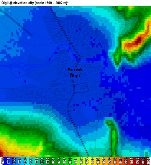
Below is the Elevation map of Ölgii, which displays elevation range with different colors. Scale of the first map is from 1699 to 2002 m (5574 to 6568 ft) with average elevation of 1742 meters (=5715 ft) [note 1]
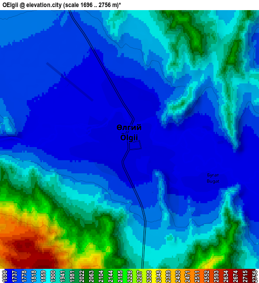
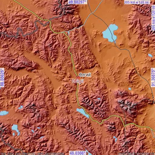
These maps also provides idea of topography and contour of this city, they are displayed at different zoom levels. More info about maps, scale and edge coordinates you can find below images.
| \ | Map #1 | Map #2 | Topo.Map |
| Scale [m] | 1699..2002 m | 1696..2756 m | × |
| Scale [ft] | 5574..6568 ft | 5564..9042 ft | × |
| Average | 1742 m = 5715 ft | 1865.4 m = 6120 ft | × |
| Width | 6.42 km = 4 mi | 12.83 km = 8 mi | 205.3 km = 127.6 mi |
| Height | 6.42 km = 4 mi | 12.83 km = 8 mi | 205.3 km = 127.6 mi |
| ↑Max Latitude | 48.997171° | 49.025995° | 49.88297° |
| Latitude at center | 48.96833° | 48.96833° | 48.96833° |
| ↓Min Latitude | 48.939473° | 48.910599° | 48.0366° |
| ← Min Longitude | 89.918555° | 89.874609° | 88.55625° |
| Longitude center | 89.9625° | 89.9625° | 89.9625° |
| →Max Longitude | 90.006445° | 90.050391° | 91.36875° |
Nearby cities:
Cities around Ölgii sort by population:
• Har-Us elevation 1271 m
120.6 km,  116°
116°
• Bayshint 1490 m
81.1 km,  16°
16°
• Chihertey 2139 m
81 km,  203°
203°
• Höhtolgoy 1404 m
77.2 km,  63°
63°
• Nogoonnuur 1484 m
74.8 km, 15°
• Tolbo 2097 m
65.7 km,  158°
158°
• Höshööt 1881 m
59.8 km,  267°
267°
• Buyant 1962 m
52.8 km,  215°
215°
• Bilüü 1772 m
39.2 km,  282°
282°
• Tsagaantüngi 1602 m
36.7 km,  75°
75°
• Uujim 1755 m
26.4 km,  253°
253°
• Buga 1816 m
2.5 km,  143°
143°
Multilingual:
 En español:
Ölgii elevación 1715 m.
 En France:
Ölgiy élévation 1715 m.


Sources and notes:
- [note 1] Map square and city borders are not equal. Map elevation data is calculated only from area inside that square.
- [src 1] Elevation data from geonames database provided with same terms of usage.
- [src 2] The elevation map of Ölgii is generated using elevation data from NASA's 3 arcsec (90m) resolution SRTM data.
- [src 3] Base (background) map © OpenStreetMap contributors tiles are generated by Geofabrik and OpenTopoMap.
Copyright & License:
This Ölgii Elevation Map is licensed under CC BY-SA. You may reuse any part from this page, if you give a proper credit by linking to this URL:
 More info on terms of use page.