Bayantsagaan elevation
Bayantsagaan (Arhangay), Mongolia elevation is 1583 meters and Bayantsagaan elevation in feet is 5194 ft above sea level [src 1]. Bayantsagaan is a seat of a second-order administrative division (feature code) with elevation that is 170 meters (558 ft) bigger than average city elevation in Mongolia.
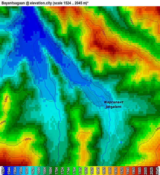
Below is the Elevation map of Bayantsagaan, which displays elevation range with different colors. Scale of the first map is from 1524 to 2045 m (5000 to 6709 ft) with average elevation of 1716.9 meters (=5633 ft) [note 1]
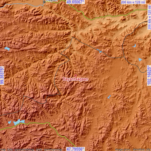
These maps also provides idea of topography and contour of this city, they are displayed at different zoom levels. More info about maps, scale and edge coordinates you can find below images.
| \ | Map #1 | Topo.Map |
| Scale [m] | 1524..2045 m | × |
| Scale [ft] | 5000..6709 ft | × |
| Average | 1716.9 m = 5633 ft | × |
| Width | 6.45 km = 4 mi | 206.3 km = 128.2 mi |
| Height | 6.45 km = 4 mi | 206.3 km = 128.2 mi |
| ↑Max Latitude | 48.760647° | 49.65067° |
| Latitude at center | 48.73167° | 48.73167° |
| ↓Min Latitude | 48.702676° | 47.79556° |
| ← Min Longitude | 100.716055° | 99.35375° |
| Longitude center | 100.76° | 100.76° |
| →Max Longitude | 100.803945° | 102.16625° |
Nearby cities:
Cities around Bayantsagaan sort by population:
• Sharga elevation 1511 m
103.1 km,  70°
70°
• Selenge 1053 m
93.5 km,  33°
33°
• Erdenet 1690 m
92.7 km,  285°
285°
• Horgo 2052 m
91.1 km,  225°
225°
• Uubulan 1352 m
87.3 km,  98°
98°
• Tsengel 1287 m
83.6 km,  6°
6°
• Teel 1935 m
78.4 km,  193°
193°
• Jargalant 1447 m
72.7 km,  329°
329°
• Rashaant 1395 m
65.7 km,  48°
48°
• Ider 1487 m
65.1 km,  274°
274°
• Öldziyt 1507 m
50.5 km,  116°
116°
• Hujirt 1687 m
38.9 km,  64°
64°
Multilingual:
 En español:
Bayantsagaan elevación 1583 m.
 En France:
Bayantsagaan élévation 1583 m.
 Auf Deutsch:
Bayantsagaan höhe über dem Meeresspiegel ist 1583 m.

Sources and notes:
- [note 1] Map square and city borders are not equal. Map elevation data is calculated only from area inside that square.
- [src 1] Elevation data from geonames database provided with same terms of usage.
- [src 2] The elevation map of Bayantsagaan is generated using elevation data from NASA's 3 arcsec (90m) resolution SRTM data.
- [src 3] Base (background) map © OpenStreetMap contributors tiles are generated by Geofabrik and OpenTopoMap.
Copyright & License:
This Bayantsagaan Elevation Map is licensed under CC BY-SA. You may reuse any part from this page, if you give a proper credit by linking to this URL:
 More info on terms of use page.