Bulag elevation
Bulag (Central Aimak), Mongolia elevation is 1430 meters and Bulag elevation in feet is 4692 ft above sea level [src 1]. Bulag is a seat of a second-order administrative division (feature code) with elevation that is 17 meters (56 ft) bigger than average city elevation in Mongolia.
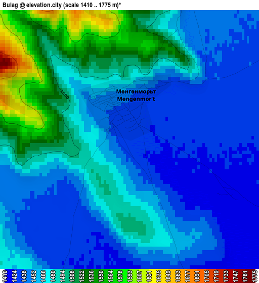
Below is the Elevation map of Bulag, which displays elevation range with different colors. Scale of the first map is from 1410 to 1775 m (4626 to 5823 ft) with average elevation of 1471.7 meters (=4828 ft) [note 1]
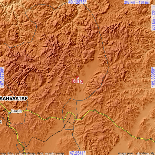
These maps also provides idea of topography and contour of this city, they are displayed at different zoom levels. More info about maps, scale and edge coordinates you can find below images.
| \ | Map #1 | Topo.Map |
| Scale [m] | 1410..1775 m | × |
| Scale [ft] | 4626..5823 ft | × |
| Average | 1471.7 m = 4828 ft | × |
| Width | 6.51 km = 4 mi | 208.4 km = 129.5 mi |
| Height | 6.51 km = 4 mi | 208.4 km = 129.5 mi |
| ↑Max Latitude | 48.229283° | 49.12875° |
| Latitude at center | 48.2° | 48.2° |
| ↓Min Latitude | 48.170701° | 47.2541° |
| ← Min Longitude | 108.439385° | 107.07708° |
| Longitude center | 108.48333° | 108.48333° |
| →Max Longitude | 108.527275° | 109.88958° |
Nearby cities:
Cities around Bulag sort by population:
• Ulan Bator elevation 1284 m
123.3 km,  254°
254°
• Зуунмод 1514 m
126.5 km,  244°
244°
• Dzuunmod 1514 m
126.5 km, 244°
• Höshigiyn-Ar 1588 m
134 km, 237°
• Mandal 1127 m
130.3 km,  278°
278°
• Maanĭt 1413 m
127.3 km,  213°
213°
• Avraga 1241 m
125.3 km,  155°
155°
• Bayasgalant 1376 m
114.7 km,  188°
188°
• Bayanbulag 1300 m
112.8 km,  109°
109°
• Modot 1505 m
65.4 km,  139°
139°
• Arhust 1569 m
63.5 km,  224°
224°
• Bayandelger 1450 m
59.4 km, 207°
Multilingual:
 En español:
Bulag elevación 1430 m.
 En France:
Bulag élévation 1430 m.


Sources and notes:
- [note 1] Map square and city borders are not equal. Map elevation data is calculated only from area inside that square.
- [src 1] Elevation data from geonames database provided with same terms of usage.
- [src 2] The elevation map of Bulag is generated using elevation data from NASA's 3 arcsec (90m) resolution SRTM data.
- [src 3] Base (background) map © OpenStreetMap contributors tiles are generated by Geofabrik and OpenTopoMap.
Copyright & License:
This Bulag Elevation Map is licensed under CC BY-SA. You may reuse any part from this page, if you give a proper credit by linking to this URL:
 More info on terms of use page.