Darhan elevation
Darhan (Darhan Uul), Mongolia elevation is 683 meters and Darhan elevation in feet is 2241 ft above sea level [src 1]. Darhan is a seat of a first-order administrative division (feature code) with elevation that is 730 meters (2395 ft) smaller than average city elevation in Mongolia.
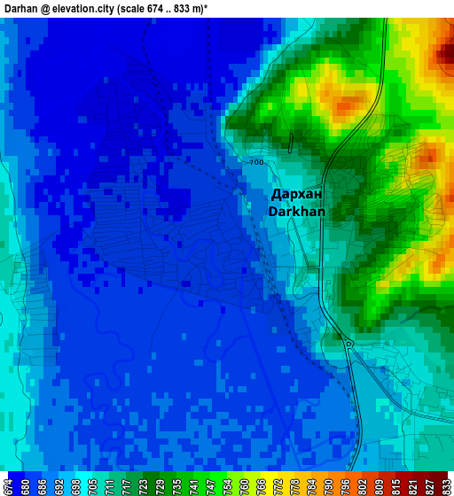
Below is the Elevation map of Darhan, which displays elevation range with different colors. Scale of the first map is from 674 to 833 m (2211 to 2733 ft) with average elevation of 701.6 meters (=2302 ft) [note 1]
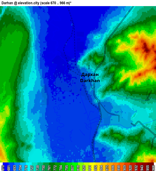
These maps also provides idea of topography and contour of this city, they are displayed at different zoom levels. More info about maps, scale and edge coordinates you can find below images.
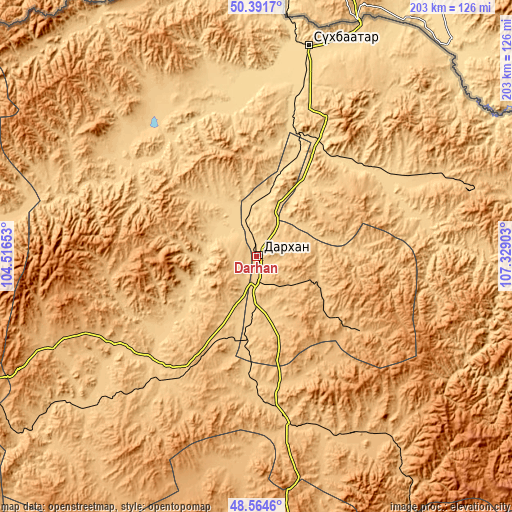
| \ | Map #1 | Map #2 | Topo.Map |
| Scale [m] | 674..833 m | 670..966 m | × |
| Scale [ft] | 2211..2733 ft | 2198..3169 ft | × |
| Average | 701.6 m = 2302 ft | 733.3 m = 2406 ft | × |
| Width | 6.35 km = 3.9 mi | 12.7 km = 7.9 mi | 203.2 km = 126.3 mi |
| Height | 6.35 km = 3.9 mi | 12.7 km = 7.9 mi | 203.1 km = 126.2 mi |
| ↑Max Latitude | 49.51521° | 49.543733° | 50.3917° |
| Latitude at center | 49.48667° | 49.48667° | 49.48667° |
| ↓Min Latitude | 49.458114° | 49.429541° | 48.5646° |
| ← Min Longitude | 105.878835° | 105.834889° | 104.51653° |
| Longitude center | 105.92278° | 105.92278° | 105.92278° |
| →Max Longitude | 105.966725° | 106.010671° | 107.32903° |
Nearby cities:
Cities around Darhan sort by population:
• Huurch elevation 765 m
77.5 km,  332°
332°
• Javhlant 864 m
76.1 km,  179°
179°
• Delgerhaan 663 m
69.2 km,  15°
15°
• Bugant 766 m
67.8 km,  80°
80°
• Jargalant 629 m
64.7 km,  357°
357°
• Nart 735 m
54.3 km,  225°
225°
• Enhtal 741 m
47.8 km,  236°
236°
• Sharïngol 904 m
46 km,  127°
127°
• Orhon 638 m
41.4 km, 21°
• Nomgon 879 m
36.9 km,  210°
210°
• Hongor 747 m
28.6 km, 183°
• Hushaat 765 m
22.2 km,  273°
273°
Multilingual:
 En español:
Darhan elevación 683 m.
 En France:
Darhan élévation 683 m.


Sources and notes:
- [note 1] Map square and city borders are not equal. Map elevation data is calculated only from area inside that square.
- [src 1] Elevation data from geonames database provided with same terms of usage.
- [src 2] The elevation map of Darhan is generated using elevation data from NASA's 3 arcsec (90m) resolution SRTM data.
- [src 3] Base (background) map © OpenStreetMap contributors tiles are generated by Geofabrik and OpenTopoMap.
Copyright & License:
This Darhan Elevation Map is licensed under CC BY-SA. You may reuse any part from this page, if you give a proper credit by linking to this URL:
 More info on terms of use page.