Erdenet elevation
Erdenet (Orhon), Mongolia elevation is 1307 meters and Erdenet elevation in feet is 4288 ft above sea level [src 1]. Erdenet is a seat of a first-order administrative division (feature code) with elevation that is 106 meters (348 ft) smaller than average city elevation in Mongolia.
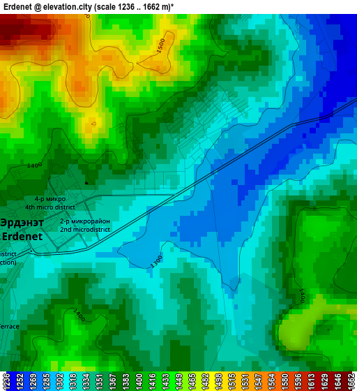
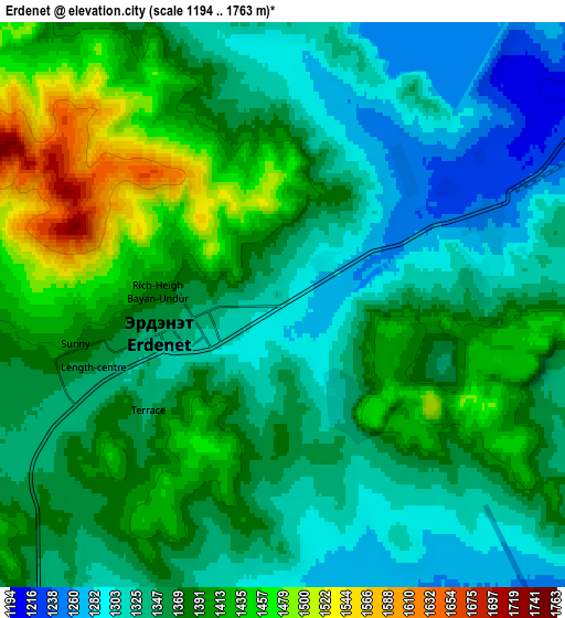
Below is the Elevation map of Erdenet, which displays elevation range with different colors. Scale of the first map is from 1236 to 1662 m (4055 to 5453 ft) with average elevation of 1366.9 meters (=4485 ft) [note 1]
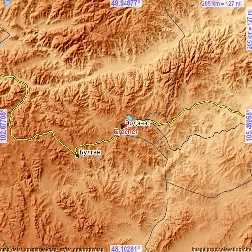
These maps also provides idea of topography and contour of this city, they are displayed at different zoom levels. More info about maps, scale and edge coordinates you can find below images.
| \ | Map #1 | Map #2 | Topo.Map |
| Scale [m] | 1236..1662 m | 1194..1763 m | × |
| Scale [ft] | 4055..5453 ft | 3917..5784 ft | × |
| Average | 1366.9 m = 4485 ft | 1368.7 m = 4490 ft | × |
| Width | 6.41 km = 4 mi | 12.81 km = 8 mi | 205 km = 127.4 mi |
| Height | 6.41 km = 4 mi | 12.81 km = 8 mi | 205 km = 127.4 mi |
| ↑Max Latitude | 49.062133° | 49.090919° | 49.94677° |
| Latitude at center | 49.03333° | 49.03333° | 49.03333° |
| ↓Min Latitude | 49.00451° | 48.975674° | 48.10281° |
| ← Min Longitude | 104.039385° | 103.995439° | 102.67708° |
| Longitude center | 104.08333° | 104.08333° | 104.08333° |
| →Max Longitude | 104.127275° | 104.171221° | 105.48958° |
Nearby cities:
Cities around Erdenet sort by population:
• Bulgan elevation 1204 m
47 km,  238°
238°
• Enhtal 741 m
96.8 km,  75°
75°
• Nart 735 m
95.8 km, 82°
• Maanĭt 1306 m
95.1 km,  210°
210°
• Darhan 1265 m
87.9 km,  189°
189°
• Orhontuul 763 m
65.8 km,  98°
98°
• Mandal 1074 m
60.4 km,  222°
222°
• Burgaltay 1016 m
54.5 km,  61°
61°
• Ingettolgoy 796 m
48.3 km,  350°
350°
• Sört 1020 m
38.3 km,  34°
34°
• Bugat 1249 m
30.6 km,  276°
276°
• Jargalant 1266 m
25.9 km,  65°
65°
Multilingual:
 En español:
Erdenet elevación 1307 m.
 En France:
Erdenet élévation 1307 m.
 Auf Deutsch:
Erdenet höhe über dem Meeresspiegel ist 1307 m.

Sources and notes:
- [note 1] Map square and city borders are not equal. Map elevation data is calculated only from area inside that square.
- [src 1] Elevation data from geonames database provided with same terms of usage.
- [src 2] The elevation map of Erdenet is generated using elevation data from NASA's 3 arcsec (90m) resolution SRTM data.
- [src 3] Base (background) map © OpenStreetMap contributors tiles are generated by Geofabrik and OpenTopoMap.
Copyright & License:
This Erdenet Elevation Map is licensed under CC BY-SA. You may reuse any part from this page, if you give a proper credit by linking to this URL:
 More info on terms of use page.