Erdenetsogt elevation
Erdenetsogt (Ömnögovĭ), Mongolia elevation is 1195 meters and Erdenetsogt elevation in feet is 3921 ft above sea level [src 1]. Erdenetsogt is a seat of a second-order administrative division (feature code) with elevation that is 218 meters (715 ft) smaller than average city elevation in Mongolia.
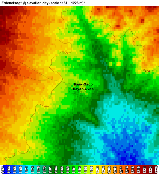
Below is the Elevation map of Erdenetsogt, which displays elevation range with different colors. Scale of the first map is from 1161 to 1226 m (3809 to 4022 ft) with average elevation of 1193.3 meters (=3915 ft) [note 1]
These maps also provides idea of topography and contour of this city, they are displayed at different zoom levels. More info about maps, scale and edge coordinates you can find below images.
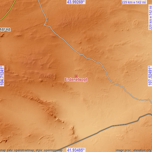
| \ | Map #1 | Topo.Map |
| Scale [m] | 1161..1226 m | × |
| Scale [ft] | 3809..4022 ft | × |
| Average | 1193.3 m = 3915 ft | × |
| Width | 7.15 km = 4.4 mi | 228.8 km = 142.2 mi |
| Height | 7.15 km = 4.4 mi | 228.8 km = 142.2 mi |
| ↑Max Latitude | 43.004526° | 43.99269° |
| Latitude at center | 42.97238° | 42.97238° |
| ↓Min Latitude | 42.940218° | 41.93485° |
| ← Min Longitude | 106.074715° | 104.71241° |
| Longitude center | 106.11866° | 106.11866° |
| →Max Longitude | 106.162605° | 107.52491° |
Nearby cities:
Cities around Erdenetsogt sort by population:
• Dalandzadgad elevation 1470 m
152.4 km,  295°
295°
• Bulgan 1296 m
242.4 km, 301°
• Ulaanjirem 1250 m
235.2 km,  349°
349°
• Naran-mandokhu Somon 1312 m
233.6 km,  47°
47°
• Dalay 1563 m
218.2 km,  284°
284°
• Doloon 1297 m
173.7 km,  338°
338°
• Tsoohor 1822 m
170 km, 282°
• Ögöömör 1517 m
160.2 km, 304°
• Üydzen 1304 m
137.5 km,  26°
26°
• Ihbulag 1103 m
91.4 km,  73°
73°
• Baruunsuu 1623 m
81.5 km, 338°
• Sangiyn Dalay 1490 m
81.2 km,  259°
259°
Multilingual:
 En español:
Erdenetsogt elevación 1195 m.
 En France:
Erdenetsogt élévation 1195 m.
 Auf Deutsch:
Erdenetsogt höhe über dem Meeresspiegel ist 1195 m.

Sources and notes:
- [note 1] Map square and city borders are not equal. Map elevation data is calculated only from area inside that square.
- [src 1] Elevation data from geonames database provided with same terms of usage.
- [src 2] The elevation map of Erdenetsogt is generated using elevation data from NASA's 3 arcsec (90m) resolution SRTM data.
- [src 3] Base (background) map © OpenStreetMap contributors tiles are generated by Geofabrik and OpenTopoMap.
Copyright & License:
This Erdenetsogt Elevation Map is licensed under CC BY-SA. You may reuse any part from this page, if you give a proper credit by linking to this URL:
 More info on terms of use page.