Murun-kuren elevation
Murun-kuren (Hövsgöl), Mongolia elevation is 1280 meters and Murun-kuren elevation in feet is 4199 ft above sea level [src 1]. Murun-kuren is a seat of a first-order administrative division (feature code) with elevation that is 133 meters (436 ft) smaller than average city elevation in Mongolia.
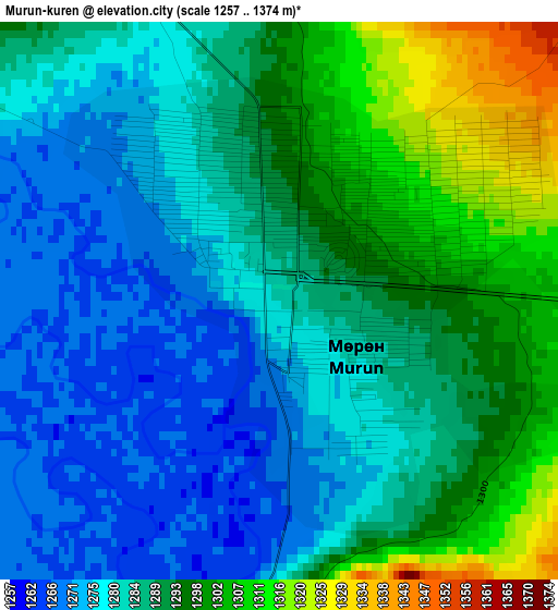
Below is the Elevation map of Murun-kuren, which displays elevation range with different colors. Scale of the first map is from 1257 to 1374 m (4124 to 4508 ft) with average elevation of 1286.7 meters (=4221 ft) [note 1]
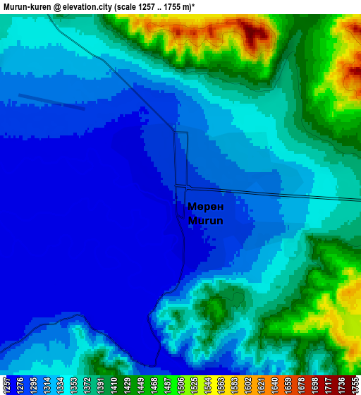
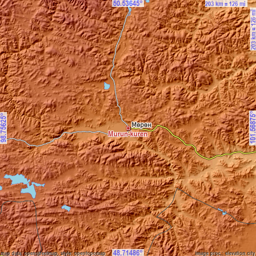
These maps also provides idea of topography and contour of this city, they are displayed at different zoom levels. More info about maps, scale and edge coordinates you can find below images.
| \ | Map #1 | Map #2 | Topo.Map |
| Scale [m] | 1257..1374 m | 1257..1755 m | × |
| Scale [ft] | 4124..4508 ft | 4124..5758 ft | × |
| Average | 1286.7 m = 4221 ft | 1347.8 m = 4422 ft | × |
| Width | 6.33 km = 3.9 mi | 12.66 km = 7.9 mi | 202.5 km = 125.8 mi |
| Height | 6.33 km = 3.9 mi | 12.66 km = 7.9 mi | 202.5 km = 125.8 mi |
| ↑Max Latitude | 49.662624° | 49.69106° | 50.53645° |
| Latitude at center | 49.63417° | 49.63417° | 49.63417° |
| ↓Min Latitude | 49.6057° | 49.577213° | 48.71486° |
| ← Min Longitude | 100.118555° | 100.074609° | 98.75625° |
| Longitude center | 100.1625° | 100.1625° | 100.1625° |
| →Max Longitude | 100.206445° | 100.250391° | 101.56875° |
Nearby cities:
Cities around Murun-kuren sort by population:
• Rashaant elevation 1395 m
107.6 km,  121°
121°
• Altraga 1617 m
104.6 km,  305°
305°
• Sharga 2002 m
99.7 km,  280°
280°
• Ider 1487 m
98 km,  192°
192°
• Selenge 1053 m
96.7 km,  103°
103°
• Erdenet 1690 m
88.7 km,  210°
210°
• Mandal 1946 m
60.1 km,  299°
299°
• Tsengel 1287 m
55.2 km,  108°
108°
• Manhan 1579 m
54.8 km,  351°
351°
• Bayan 1749 m
46.3 km,  241°
241°
• Bulag 1531 m
41.7 km,  53°
53°
• Jargalant 1447 m
38.2 km,  169°
169°
Multilingual:
 En español:
Murun-kuren elevación 1280 m.
 En France:
Mörön élévation 1280 m.
 Auf Deutsch:
Murun-kuren höhe über dem Meeresspiegel ist 1280 m.

Sources and notes:
- [note 1] Map square and city borders are not equal. Map elevation data is calculated only from area inside that square.
- [src 1] Elevation data from geonames database provided with same terms of usage.
- [src 2] The elevation map of Murun-kuren is generated using elevation data from NASA's 3 arcsec (90m) resolution SRTM data.
- [src 3] Base (background) map © OpenStreetMap contributors tiles are generated by Geofabrik and OpenTopoMap.
Copyright & License:
This Murun-kuren Elevation Map is licensed under CC BY-SA. You may reuse any part from this page, if you give a proper credit by linking to this URL:
 More info on terms of use page.