Tessalit elevation
Tessalit (Kidal), Mali elevation is 517 meters and Tessalit elevation in feet is 1696 ft above sea level [src 1]. Tessalit is a seat of a second-order administrative division (feature code) with elevation that is 209 meters (686 ft) bigger than average city elevation in Mali.
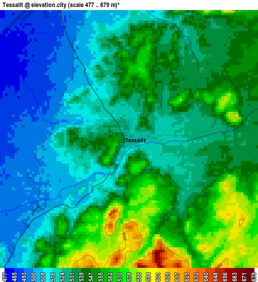
Below is the Elevation map of Tessalit, which displays elevation range with different colors. Scale of the first map is from 477 to 679 m (1565 to 2228 ft) with average elevation of 534.5 meters (=1754 ft) [note 1]
These maps also provides idea of topography and contour of this city, they are displayed at different zoom levels. More info about maps, scale and edge coordinates you can find below images.
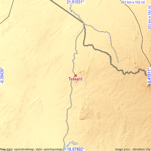
| \ | Map #1 | Topo.Map |
| Scale [m] | 477..679 m | × |
| Scale [ft] | 1565..2228 ft | × |
| Average | 534.5 m = 1754 ft | × |
| Width | 9.17 km = 5.7 mi | 293.5 km = 182.4 mi |
| Height | 9.17 km = 5.7 mi | 293.5 km = 182.4 mi |
| ↑Max Latitude | 20.242497° | 21.51531° |
| Latitude at center | 20.20126° | 20.20126° |
| ↓Min Latitude | 20.160013° | 18.87602° |
| ← Min Longitude | 0.967915° | -0.39439° |
| Longitude center | 1.01186° | 1.01186° |
| →Max Longitude | 1.055805° | 2.41811° |
Nearby cities:
Cities around Tessalit sort by population:
• Kidal elevation 460 m
200.1 km,  168°
168°
• Bourem 270 m
388.4 km,  201°
201°
• Ti-n-Essako 487 m
248.7 km,  141°
141°
• Abeïbara 538 m
143.2 km,  147°
147°
Multilingual:
 En español:
Tessalit elevación 517 m.
 En France:
Tessalit élévation 517 m.
 Auf Deutsch:
Tessalit höhe über dem Meeresspiegel ist 517 m.

Sources and notes:
- [note 1] Map square and city borders are not equal. Map elevation data is calculated only from area inside that square.
- [src 1] Elevation data from geonames database provided with same terms of usage.
- [src 2] The elevation map of Tessalit is generated using elevation data from NASA's 3 arcsec (90m) resolution SRTM data.
- [src 3] Base (background) map © OpenStreetMap contributors tiles are generated by Geofabrik and OpenTopoMap.
Copyright & License:
This Tessalit Elevation Map is licensed under CC BY-SA. You may reuse any part from this page, if you give a proper credit by linking to this URL:
 More info on terms of use page.