Čair elevation
Čair, North Macedonia elevation is 270 meters and Čair elevation in feet is 886 ft above sea level [src 1]. Čair is a seat of a first-order administrative division (feature code) with elevation that is 229 meters (751 ft) smaller than average city elevation in North Macedonia.
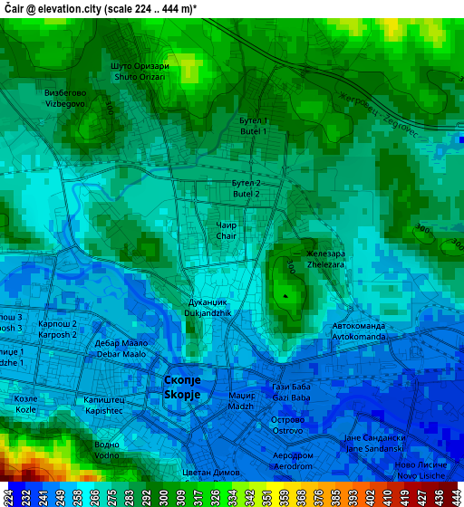
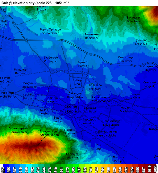
Below is the Elevation map of Čair, which displays elevation range with different colors. Scale of the first map is from 224 to 444 m (735 to 1457 ft) with average elevation of 275.2 meters (=903 ft) [note 1]
These maps also provides idea of topography and contour of this city, they are displayed at different zoom levels. More info about maps, scale and edge coordinates you can find below images.
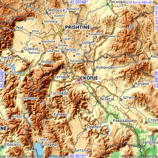
| \ | Map #1 | Map #2 | Topo.Map |
| Scale [m] | 224..444 m | 223..1051 m | × |
| Scale [ft] | 735..1457 ft | 732..3448 ft | × |
| Average | 275.2 m = 903 ft | 355.1 m = 1165 ft | × |
| Width | 7.26 km = 4.5 mi | 14.52 km = 9 mi | 232.3 km = 144.3 mi |
| Height | 7.26 km = 4.5 mi | 14.52 km = 9 mi | 232.3 km = 144.3 mi |
| ↑Max Latitude | 42.047922° | 42.080546° | 43.05148° |
| Latitude at center | 42.01528° | 42.01528° | 42.01528° |
| ↓Min Latitude | 41.982622° | 41.949947° | 40.96191° |
| ← Min Longitude | 21.397165° | 21.353219° | 20.03486° |
| Longitude center | 21.44111° | 21.44111° | 21.44111° |
| →Max Longitude | 21.485055° | 21.529001° | 22.84736° |
Nearby cities:
Cities around Čair sort by population:
• Skopje elevation 247 m
2.2 km,  200°
200°
• Kisela Voda 239 m
9 km,  145°
145°
• Gjorče Petro 263 m
7.3 km,  263°
263°
• Butel 288 m
1.8 km,  14°
14°
• Saraj 271 m
9.5 km, 259°
• Šuto Orizare 307 m
3.1 km,  334°
334°
• Сопиште 501 m
6.8 km,  189°
189°
• Radishani 400 m
5.1 km, 6°
• Cresevo 341 m
6.9 km,  55°
55°
• Krušopek 519 m
8.3 km,  240°
240°
• Usje 287 m
6.4 km,  167°
167°
• Булачани 482 m
8 km,  39°
39°
Multilingual:
 En español:
Čair elevación 270 m.
 En France:
Čair élévation 270 m.


Sources and notes:
- [note 1] Map square and city borders are not equal. Map elevation data is calculated only from area inside that square.
- [src 1] Elevation data from geonames database provided with same terms of usage.
- [src 2] The elevation map of Čair is generated using elevation data from NASA's 3 arcsec (90m) resolution SRTM data.
- [src 3] Base (background) map © OpenStreetMap contributors tiles are generated by Geofabrik and OpenTopoMap.
Copyright & License:
This Čair Elevation Map is licensed under CC BY-SA. You may reuse any part from this page, if you give a proper credit by linking to this URL:
 More info on terms of use page.