Jankovec elevation
Jankovec (Resen), North Macedonia elevation is 905 meters and Jankovec elevation in feet is 2969 ft above sea level [src 1]. Jankovec is a populated place (feature code) with elevation that is 406 meters (1332 ft) bigger than average city elevation in North Macedonia.
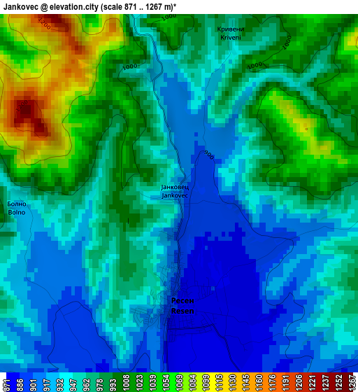
Below is the Elevation map of Jankovec, which displays elevation range with different colors. Scale of the first map is from 871 to 1267 m (2858 to 4157 ft) with average elevation of 966.7 meters (=3172 ft) [note 1]
These maps also provides idea of topography and contour of this city, they are displayed at different zoom levels. More info about maps, scale and edge coordinates you can find below images.
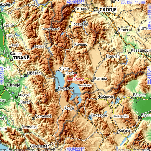
| \ | Map #1 | Topo.Map |
| Scale [m] | 871..1267 m | × |
| Scale [ft] | 2858..4157 ft | × |
| Average | 966.7 m = 3172 ft | × |
| Width | 7.36 km = 4.6 mi | 235.6 km = 146.4 mi |
| Height | 7.36 km = 4.6 mi | 235.6 km = 146.4 mi |
| ↑Max Latitude | 41.143382° | 42.16125° |
| Latitude at center | 41.11028° | 41.11028° |
| ↓Min Latitude | 41.077161° | 40.04221° |
| ← Min Longitude | 20.967445° | 19.60514° |
| Longitude center | 21.01139° | 21.01139° |
| →Max Longitude | 21.055335° | 22.41764° |
Nearby cities:
Cities around Jankovec sort by population:
• Ohrid elevation 701 m
17.6 km,  272°
272°
• Resen 882 m
2.3 km,  180°
180°
• Belčišta 770 m
26.2 km,  324°
324°
• Mešeišta 757 m
24.4 km,  305°
305°
• Kukurečani 602 m
26.3 km,  93°
93°
• Demir Hisar 644 m
20.2 km,  52°
52°
• Sopotnica 663 m
23.8 km,  29°
29°
• Capari 1006 m
15.3 km,  113°
113°
• Kosel 747 m
16.4 km,  295°
295°
• Grnčari 895 m
10.9 km,  161°
161°
• Krani 962 m
20.7 km, 156°
• Slepče 672 m
19.4 km, 45°
Multilingual:
 En español:
Jankovec elevación 905 m.
 En France:
Jankovec élévation 905 m.
 Auf Deutsch:
Jankovec höhe über dem Meeresspiegel ist 905 m.

Sources and notes:
- [note 1] Map square and city borders are not equal. Map elevation data is calculated only from area inside that square.
- [src 1] Elevation data from geonames database provided with same terms of usage.
- [src 2] The elevation map of Jankovec is generated using elevation data from NASA's 3 arcsec (90m) resolution SRTM data.
- [src 3] Base (background) map © OpenStreetMap contributors tiles are generated by Geofabrik and OpenTopoMap.
Copyright & License:
This Jankovec Elevation Map is licensed under CC BY-SA. You may reuse any part from this page, if you give a proper credit by linking to this URL:
 More info on terms of use page.