Kamenjane elevation
Kamenjane (Bogovinje), North Macedonia elevation is 485 meters and Kamenjane elevation in feet is 1591 ft above sea level [src 1]. Kamenjane is a populated place (feature code) with elevation that is 14 meters (46 ft) smaller than average city elevation in North Macedonia.
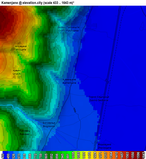
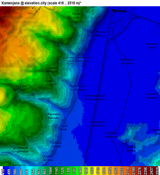
Below is the Elevation map of Kamenjane, which displays elevation range with different colors. Scale of the first map is from 433 to 1643 m (1421 to 5390 ft) with average elevation of 661.4 meters (=2170 ft) [note 1]
These maps also provides idea of topography and contour of this city, they are displayed at different zoom levels. More info about maps, scale and edge coordinates you can find below images.
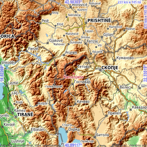
| \ | Map #1 | Map #2 | Topo.Map |
| Scale [m] | 433..1643 m | 418..2518 m | × |
| Scale [ft] | 1421..5390 ft | 1371..8261 ft | × |
| Average | 661.4 m = 2170 ft | 835.9 m = 2742 ft | × |
| Width | 7.27 km = 4.5 mi | 14.54 km = 9 mi | 232.6 km = 144.5 mi |
| Height | 7.27 km = 4.5 mi | 14.54 km = 9 mi | 232.6 km = 144.5 mi |
| ↑Max Latitude | 41.978357° | 42.011018° | 42.98303° |
| Latitude at center | 41.94568° | 41.94568° | 41.94568° |
| ↓Min Latitude | 41.912986° | 41.880275° | 40.89117° |
| ← Min Longitude | 20.884995° | 20.841049° | 19.52269° |
| Longitude center | 20.92894° | 20.92894° | 20.92894° |
| →Max Longitude | 20.972885° | 21.016831° | 22.33519° |
Nearby cities:
Cities around Kamenjane sort by population:
• Tetovo elevation 466 m
7.9 km,  26°
26°
• Negotino 576 m
8.4 km,  206°
206°
• Brvenica 435 m
4.9 km,  60°
60°
• Bogovinje 539 m
2.8 km, 207°
• Čelopek 464 m
7.2 km,  102°
102°
• Dobri Dol 555 m
9.5 km,  199°
199°
• Pirok 517 m
4.2 km, 201°
• Gradec 538 m
5.9 km, 200°
• Golema Rečica 472 m
4.9 km,  15°
15°
• Dolno Palčište 512 m
2.5 km,  0°
0°
• Strimnica 438 m
9.2 km,  74°
74°
• Miletino 501 m
8.4 km,  120°
120°
Multilingual:
 En español:
Kamenjane elevación 485 m.
 En France:
Kamenjane élévation 485 m.
 Auf Deutsch:
Kamenjane höhe über dem Meeresspiegel ist 485 m.

Sources and notes:
- [note 1] Map square and city borders are not equal. Map elevation data is calculated only from area inside that square.
- [src 1] Elevation data from geonames database provided with same terms of usage.
- [src 2] The elevation map of Kamenjane is generated using elevation data from NASA's 3 arcsec (90m) resolution SRTM data.
- [src 3] Base (background) map © OpenStreetMap contributors tiles are generated by Geofabrik and OpenTopoMap.
Copyright & License:
This Kamenjane Elevation Map is licensed under CC BY-SA. You may reuse any part from this page, if you give a proper credit by linking to this URL:
 More info on terms of use page.