Kumanovo elevation
Kumanovo, North Macedonia elevation is 344 meters and Kumanovo elevation in feet is 1129 ft above sea level [src 1]. Kumanovo is a seat of a first-order administrative division (feature code) with elevation that is 155 meters (509 ft) smaller than average city elevation in North Macedonia.
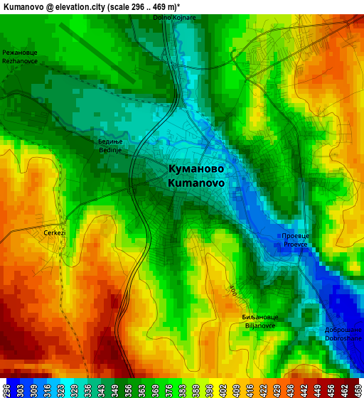
Below is the Elevation map of Kumanovo, which displays elevation range with different colors. Scale of the first map is from 296 to 469 m (971 to 1539 ft) with average elevation of 377.8 meters (=1240 ft) [note 1]
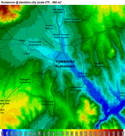
These maps also provides idea of topography and contour of this city, they are displayed at different zoom levels. More info about maps, scale and edge coordinates you can find below images.
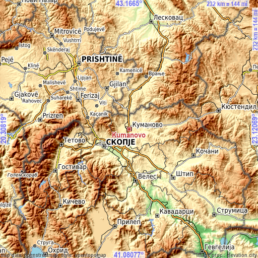
| \ | Map #1 | Map #2 | Topo.Map |
| Scale [m] | 296..469 m | 275..668 m | × |
| Scale [ft] | 971..1539 ft | 902..2192 ft | × |
| Average | 377.8 m = 1240 ft | 405.8 m = 1331 ft | × |
| Width | 7.25 km = 4.5 mi | 14.49 km = 9 mi | 231.9 km = 144.1 mi |
| Height | 7.25 km = 4.5 mi | 14.49 km = 9 mi | 231.9 km = 144.1 mi |
| ↑Max Latitude | 42.164801° | 42.197366° | 43.1665° |
| Latitude at center | 42.13222° | 42.13222° | 42.13222° |
| ↓Min Latitude | 42.099622° | 42.067007° | 41.08077° |
| ← Min Longitude | 21.670495° | 21.626549° | 20.30819° |
| Longitude center | 21.71444° | 21.71444° | 21.71444° |
| →Max Longitude | 21.758385° | 21.802331° | 23.12069° |
Nearby cities:
Cities around Kumanovo sort by population:
• Lipkovo elevation 441 m
11 km,  284°
284°
• Старо Нагоричане 427 m
11.9 km,  52°
52°
• Matejce 482 m
9.6 km,  265°
265°
• Слупчане 413 m
8.5 km,  302°
302°
• Romanovci 410 m
4.5 km,  202°
202°
• Otlja 473 m
10.6 km, 276°
• Bedinje 340 m
1.8 km,  305°
305°
• Lojane 437 m
11.9 km,  340°
340°
• Vaksince 463 m
9.2 km,  332°
332°
• Клечовце 309 m
11.9 km,  98°
98°
• Orashac 389 m
10.5 km,  137°
137°
• Izvor 816 m
13.7 km, 305°
Multilingual:
 En español:
Kumanovo elevación 344 m.
 En France:
Koumanovo élévation 344 m.
 Auf Deutsch:
Kumanovo höhe über dem Meeresspiegel ist 344 m.

Sources and notes:
- [note 1] Map square and city borders are not equal. Map elevation data is calculated only from area inside that square.
- [src 1] Elevation data from geonames database provided with same terms of usage.
- [src 2] The elevation map of Kumanovo is generated using elevation data from NASA's 3 arcsec (90m) resolution SRTM data.
- [src 3] Base (background) map © OpenStreetMap contributors tiles are generated by Geofabrik and OpenTopoMap.
Copyright & License:
This Kumanovo Elevation Map is licensed under CC BY-SA. You may reuse any part from this page, if you give a proper credit by linking to this URL:
 More info on terms of use page.