Sedlarevo elevation
Sedlarevo (Zhelino), North Macedonia elevation is 1229 meters and Sedlarevo elevation in feet is 4032 ft above sea level [src 1]. Sedlarevo is a populated place (feature code) with elevation that is 730 meters (2395 ft) bigger than average city elevation in North Macedonia.
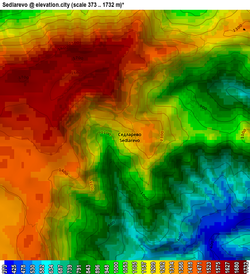
Below is the Elevation map of Sedlarevo, which displays elevation range with different colors. Scale of the first map is from 373 to 1732 m (1224 to 5682 ft) with average elevation of 1144.2 meters (=3754 ft) [note 1]
These maps also provides idea of topography and contour of this city, they are displayed at different zoom levels. More info about maps, scale and edge coordinates you can find below images.
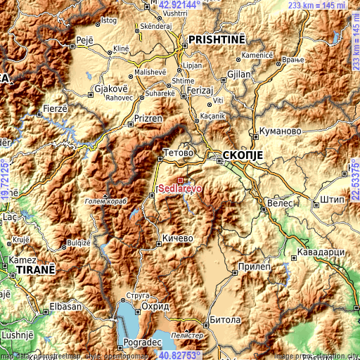
| \ | Map #1 | Topo.Map |
| Scale [m] | 373..1732 m | × |
| Scale [ft] | 1224..5682 ft | × |
| Average | 1144.2 m = 3754 ft | × |
| Width | 7.28 km = 4.5 mi | 232.8 km = 144.7 mi |
| Height | 7.28 km = 4.5 mi | 232.8 km = 144.7 mi |
| ↑Max Latitude | 41.915769° | 42.92144° |
| Latitude at center | 41.88306° | 41.88306° |
| ↓Min Latitude | 41.850334° | 40.82753° |
| ← Min Longitude | 21.083555° | 19.72125° |
| Longitude center | 21.1275° | 21.1275° |
| →Max Longitude | 21.171445° | 22.53375° |
Nearby cities:
Cities around Sedlarevo sort by population:
• Zelino elevation 448 m
12 km,  334°
334°
• Brvenica 435 m
15.3 km,  307°
307°
• Cegrane 488 m
13.5 km,  248°
248°
• Čelopek 464 m
10.9 km,  299°
299°
• Forino 491 m
15.2 km,  244°
244°
• Strimnica 438 m
12 km,  321°
321°
• Miletino 501 m
9.6 km,  286°
286°
• Bojane 510 m
14.1 km,  22°
22°
• Larce 579 m
5.6 km,  358°
358°
• Dobarce 580 m
8.6 km,  338°
338°
• Bukovik 393 m
13.1 km,  43°
43°
• Gurgurnica 1249 m
4.6 km,  203°
203°
Multilingual:
 En español:
Sedlarevo elevación 1229 m.
 En France:
Sedlarevo élévation 1229 m.
 Auf Deutsch:
Sedlarevo höhe über dem Meeresspiegel ist 1229 m.

Sources and notes:
- [note 1] Map square and city borders are not equal. Map elevation data is calculated only from area inside that square.
- [src 1] Elevation data from geonames database provided with same terms of usage.
- [src 2] The elevation map of Sedlarevo is generated using elevation data from NASA's 3 arcsec (90m) resolution SRTM data.
- [src 3] Base (background) map © OpenStreetMap contributors tiles are generated by Geofabrik and OpenTopoMap.
Copyright & License:
This Sedlarevo Elevation Map is licensed under CC BY-SA. You may reuse any part from this page, if you give a proper credit by linking to this URL:
 More info on terms of use page.