Ambatolampy elevation
Ambatolampy (Vakinankaratra), Madagascar elevation is 1586 meters and Ambatolampy elevation in feet is 5203 ft above sea level [src 1]. Ambatolampy is a populated place (feature code) with elevation that is 1029 meters (3376 ft) bigger than average city elevation in Madagascar.
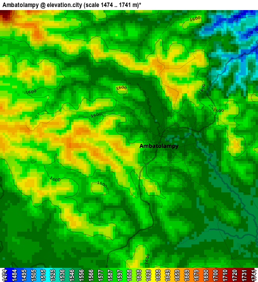
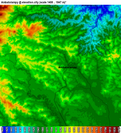
Below is the Elevation map of Ambatolampy, which displays elevation range with different colors. Scale of the first map is from 1474 to 1741 m (4836 to 5712 ft) with average elevation of 1588.3 meters (=5211 ft) [note 1]
These maps also provides idea of topography and contour of this city, they are displayed at different zoom levels. More info about maps, scale and edge coordinates you can find below images.
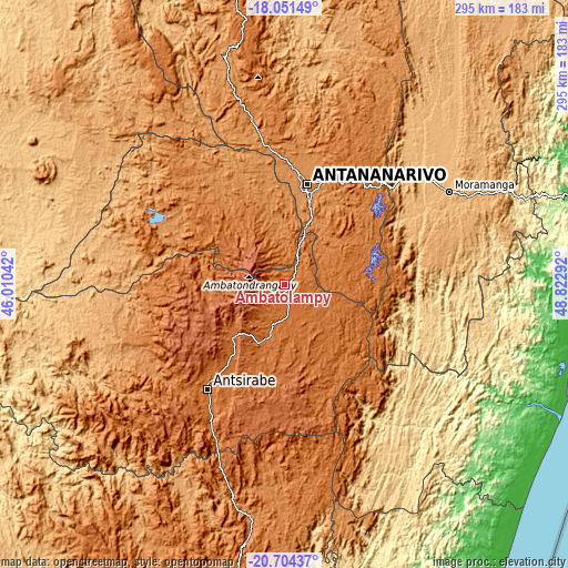
| \ | Map #1 | Map #2 | Topo.Map |
| Scale [m] | 1474..1741 m | 1408..1847 m | × |
| Scale [ft] | 4836..5712 ft | 4619..6060 ft | × |
| Average | 1588.3 m = 5211 ft | 1581.5 m = 5189 ft | × |
| Width | 9.22 km = 5.7 mi | 18.44 km = 11.5 mi | 295 km = 183.3 mi |
| Height | 9.22 km = 5.7 mi | 18.44 km = 11.5 mi | 295 km = 183.3 mi |
| ↑Max Latitude | -19.34187° | -19.3004° | -18.05149° |
| Latitude at center | -19.38333° | -19.38333° | -19.38333° |
| ↓Min Latitude | -19.424779° | -19.466218° | -20.70437° |
| ← Min Longitude | 47.372725° | 47.328779° | 46.01042° |
| Longitude center | 47.41667° | 47.41667° | 47.41667° |
| →Max Longitude | 47.460615° | 47.504561° | 48.82292° |
Nearby cities:
Cities around Ambatolampy sort by population:
• Antananarivo elevation 1274 m
53.7 km,  13°
13°
• Antanifotsy 1571 m
31.4 km,  199°
199°
• Faratsiho 1729 m
49 km,  267°
267°
• Arivonimamo 1418 m
47.6 km,  328°
328°
• Soanindrariny 1763 m
60.6 km, 198°
• Alarobia 1389 m
57 km,  35°
35°
• Mantasoa 1377 m
59.8 km,  47°
47°
• Miadanandriana 1358 m
54.7 km, 44°
• Merikanjaka 1560 m
53.3 km,  58°
58°
• Ambohitrandriamanitra 1465 m
50.9 km, 49°
• Antsampanimahazo 1676 m
39.5 km,  223°
223°
• Andramasina 1360 m
28.4 km, 39°
Multilingual:
 En español:
Ambatolampy elevación 1586 m.
 En France:
Ambatolampy élévation 1586 m.
 Auf Deutsch:
Ambatolampy höhe über dem Meeresspiegel ist 1586 m.

Sources and notes:
- [note 1] Map square and city borders are not equal. Map elevation data is calculated only from area inside that square.
- [src 1] Elevation data from geonames database provided with same terms of usage.
- [src 2] The elevation map of Ambatolampy is generated using elevation data from NASA's 3 arcsec (90m) resolution SRTM data.
- [src 3] Base (background) map © OpenStreetMap contributors tiles are generated by Geofabrik and OpenTopoMap.
Copyright & License:
This Ambatolampy Elevation Map is licensed under CC BY-SA. You may reuse any part from this page, if you give a proper credit by linking to this URL:
 More info on terms of use page.