Manjakandriana elevation
Manjakandriana (Analamanga), Madagascar elevation is 1462 meters and Manjakandriana elevation in feet is 4797 ft above sea level [src 1]. Manjakandriana is a populated place (feature code) with elevation that is 905 meters (2969 ft) bigger than average city elevation in Madagascar.
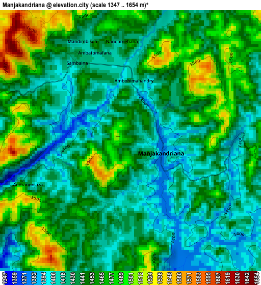
Below is the Elevation map of Manjakandriana, which displays elevation range with different colors. Scale of the first map is from 1347 to 1654 m (4419 to 5427 ft) with average elevation of 1446.4 meters (=4745 ft) [note 1]
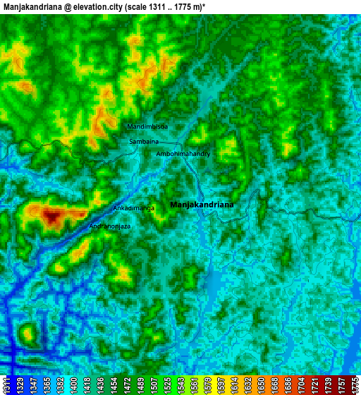
These maps also provides idea of topography and contour of this city, they are displayed at different zoom levels. More info about maps, scale and edge coordinates you can find below images.
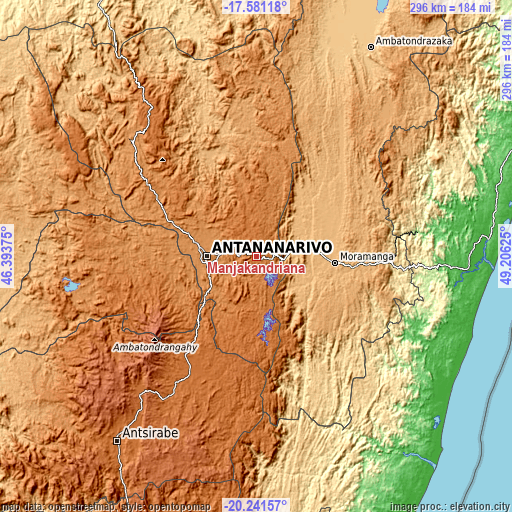
| \ | Map #1 | Map #2 | Topo.Map |
| Scale [m] | 1347..1654 m | 1311..1775 m | × |
| Scale [ft] | 4419..5427 ft | 4301..5823 ft | × |
| Average | 1446.4 m = 4745 ft | 1447.1 m = 4748 ft | × |
| Width | 9.24 km = 5.7 mi | 18.49 km = 11.5 mi | 295.8 km = 183.8 mi |
| Height | 9.24 km = 5.7 mi | 18.49 km = 11.5 mi | 295.8 km = 183.8 mi |
| ↑Max Latitude | -18.875093° | -18.833506° | -17.58118° |
| Latitude at center | -18.91667° | -18.91667° | -18.91667° |
| ↓Min Latitude | -18.958237° | -18.999793° | -20.24157° |
| ← Min Longitude | 47.756055° | 47.712109° | 46.39375° |
| Longitude center | 47.8° | 47.8° | 47.8° |
| →Max Longitude | 47.843945° | 47.887891° | 49.20625° |
Nearby cities:
Cities around Manjakandriana sort by population:
• Ambohitrolomahitsy elevation 1502 m
27 km,  332°
332°
• Ankazondandy 1378 m
24.2 km,  355°
355°
• Alarobia 1389 m
8.9 km,  231°
231°
• Miadanandriana 1358 m
13.1 km,  187°
187°
• Mantasoa 1377 m
11.7 km,  162°
162°
• Merikanjaka 1560 m
24.7 km,  167°
167°
• Ambohitrandriamanitra 1465 m
18.6 km, 185°
• Sambaina 1459 m
2.6 km,  316°
316°
• Ambohitseheno 1479 m
14.8 km,  0°
0°
• Anjepy 1550 m
11.5 km,  310°
310°
• Ambatolaona 1403 m
10.7 km,  99°
99°
• Nandihizana 1365 m
9 km,  281°
281°
Multilingual:
 En español:
Manjakandriana elevación 1462 m.
 En France:
Manjakandriana élévation 1462 m.
 Auf Deutsch:
Manjakandriana höhe über dem Meeresspiegel ist 1462 m.

Sources and notes:
- [note 1] Map square and city borders are not equal. Map elevation data is calculated only from area inside that square.
- [src 1] Elevation data from geonames database provided with same terms of usage.
- [src 2] The elevation map of Manjakandriana is generated using elevation data from NASA's 3 arcsec (90m) resolution SRTM data.
- [src 3] Base (background) map © OpenStreetMap contributors tiles are generated by Geofabrik and OpenTopoMap.
Copyright & License:
This Manjakandriana Elevation Map is licensed under CC BY-SA. You may reuse any part from this page, if you give a proper credit by linking to this URL:
 More info on terms of use page.