Sahavato elevation
Sahavato (Vatovavy Fitovinany, Nosy-Varika), Madagascar elevation is 54 meters and Sahavato elevation in feet is 177 ft above sea level [src 1]. Sahavato is a populated place (feature code) with elevation that is 503 meters (1650 ft) smaller than average city elevation in Madagascar.
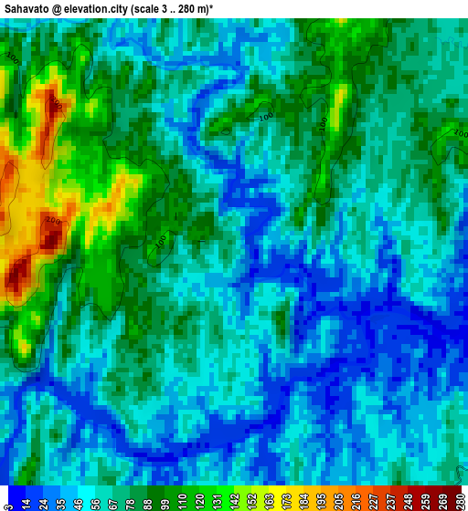
Below is the Elevation map of Sahavato, which displays elevation range with different colors. Scale of the first map is from 3 to 280 m (10 to 919 ft) with average elevation of 70.3 meters (=231 ft) [note 1]
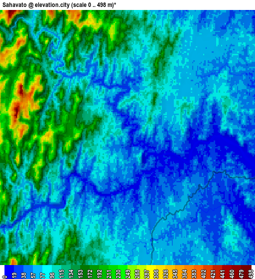
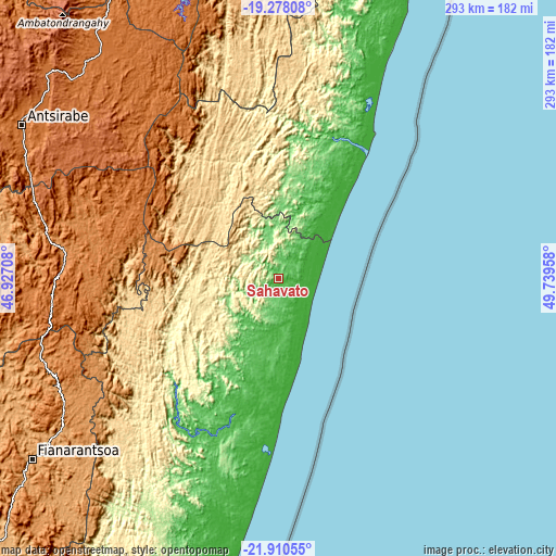
These maps also provides idea of topography and contour of this city, they are displayed at different zoom levels. More info about maps, scale and edge coordinates you can find below images.
| \ | Map #1 | Map #2 | Topo.Map |
| Scale [m] | 3..280 m | 0..498 m | × |
| Scale [ft] | 10..919 ft | 0..1634 ft | × |
| Average | 70.3 m = 231 ft | 96.9 m = 318 ft | × |
| Width | 9.15 km = 5.7 mi | 18.3 km = 11.4 mi | 292.7 km = 181.9 mi |
| Height | 9.15 km = 5.7 mi | 18.3 km = 11.4 mi | 292.7 km = 181.9 mi |
| ↑Max Latitude | -20.558859° | -20.517707° | -19.27808° |
| Latitude at center | -20.6° | -20.6° | -20.6° |
| ↓Min Latitude | -20.64113° | -20.682249° | -21.91055° |
| ← Min Longitude | 48.289385° | 48.245439° | 46.92708° |
| Longitude center | 48.33333° | 48.33333° | 48.33333° |
| →Max Longitude | 48.377275° | 48.421221° | 49.73958° |
Nearby cities:
Cities around Sahavato sort by population:
• Antsirabe elevation 1513 m
158.3 km,  301°
301°
• Antanifotsy 1571 m
149.7 km,  314°
314°
• Mahanoro 3 m
91.8 km,  32°
32°
• Nosy Varika 8 m
20.9 km,  84°
84°
• Fandriana 1364 m
107.1 km,  292°
292°
• Ambositra 1318 m
113.7 km,  273°
273°
• Mananjary 7 m
70.1 km,  179°
179°
• Marolambo 424 m
65.2 km,  339°
339°
• Soanindrariny 1763 m
138.7 km, 304°
• Ifanadiana 433 m
106.5 km,  223°
223°
• Fandrandava 1173 m
151.7 km,  227°
227°
• Vohimanitra 213 m
138.8 km,  208°
208°
Multilingual:
 En español:
Sahavato elevación 54 m.
 En France:
Sahavato élévation 54 m.


Sources and notes:
- [note 1] Map square and city borders are not equal. Map elevation data is calculated only from area inside that square.
- [src 1] Elevation data from geonames database provided with same terms of usage.
- [src 2] The elevation map of Sahavato is generated using elevation data from NASA's 3 arcsec (90m) resolution SRTM data.
- [src 3] Base (background) map © OpenStreetMap contributors tiles are generated by Geofabrik and OpenTopoMap.
Copyright & License:
This Sahavato Elevation Map is licensed under CC BY-SA. You may reuse any part from this page, if you give a proper credit by linking to this URL:
 More info on terms of use page.