Sakaraha elevation
Sakaraha (Atsimo-Andrefana, Sakaraha District), Madagascar elevation is 480 meters and Sakaraha elevation in feet is 1575 ft above sea level [src 1]. Sakaraha is a populated place (feature code) with elevation that is 77 meters (253 ft) smaller than average city elevation in Madagascar.
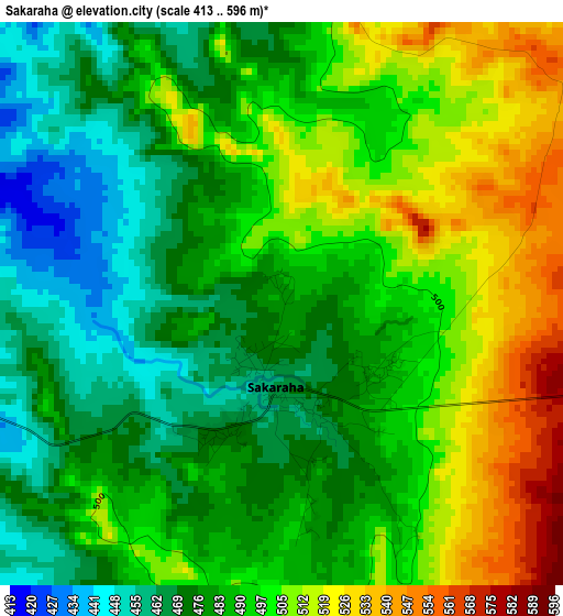
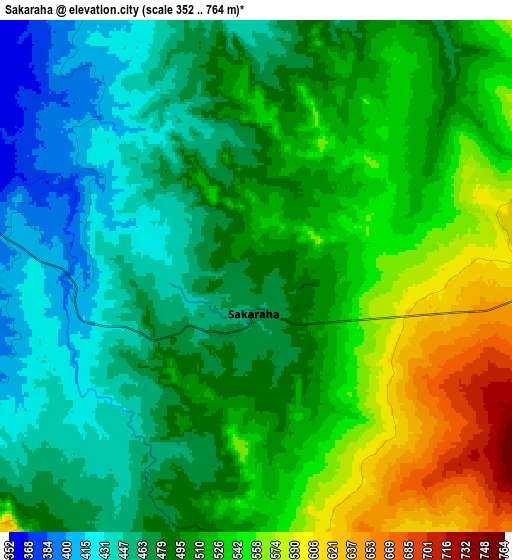
Below is the Elevation map of Sakaraha, which displays elevation range with different colors. Scale of the first map is from 413 to 596 m (1355 to 1955 ft) with average elevation of 490.9 meters (=1611 ft) [note 1]
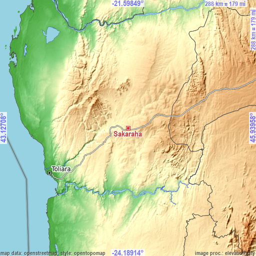
These maps also provides idea of topography and contour of this city, they are displayed at different zoom levels. More info about maps, scale and edge coordinates you can find below images.
| \ | Map #1 | Map #2 | Topo.Map |
| Scale [m] | 413..596 m | 352..764 m | × |
| Scale [ft] | 1355..1955 ft | 1155..2507 ft | × |
| Average | 490.9 m = 1611 ft | 502.8 m = 1650 ft | × |
| Width | 9 km = 5.6 mi | 18 km = 11.2 mi | 288.1 km = 179 mi |
| Height | 9 km = 5.6 mi | 18 km = 11.2 mi | 288.1 km = 179 mi |
| ↑Max Latitude | -22.859512° | -22.819012° | -21.59849° |
| Latitude at center | -22.9° | -22.9° | -22.9° |
| ↓Min Latitude | -22.940476° | -22.980939° | -24.18914° |
| ← Min Longitude | 44.489385° | 44.445439° | 43.12708° |
| Longitude center | 44.53333° | 44.53333° | 44.53333° |
| →Max Longitude | 44.577275° | 44.621221° | 45.93958° |
Nearby cities:
Cities around Sakaraha sort by population:
• Toliara elevation 11 m
101.8 km,  240°
240°
• Betioky 257 m
92.6 km,  189°
189°
• Ankazoabo 398 m
68.6 km,  358°
358°
• Beroroha 205 m
151.8 km,  25°
25°
• Ihosy 733 m
172.5 km,  71°
71°
• Beteza 304 m
182.3 km,  160°
160°
• Behompy 49 m
80 km, 240°
• Ranohira 723 m
100.3 km,  62°
62°
• Ambalasoa 883 m
152 km,  99°
99°
• Antanimena 79 m
84.8 km,  211°
211°
• Anakao 2 m
124.1 km,  226°
226°
• Manja 256 m
164.4 km,  352°
352°
Multilingual:
 En español:
Sakaraha elevación 480 m.
 En France:
Sakaraha élévation 480 m.
 Auf Deutsch:
Sakaraha höhe über dem Meeresspiegel ist 480 m.

Sources and notes:
- [note 1] Map square and city borders are not equal. Map elevation data is calculated only from area inside that square.
- [src 1] Elevation data from geonames database provided with same terms of usage.
- [src 2] The elevation map of Sakaraha is generated using elevation data from NASA's 3 arcsec (90m) resolution SRTM data.
- [src 3] Base (background) map © OpenStreetMap contributors tiles are generated by Geofabrik and OpenTopoMap.
Copyright & License:
This Sakaraha Elevation Map is licensed under CC BY-SA. You may reuse any part from this page, if you give a proper credit by linking to this URL:
 More info on terms of use page.