Camenca elevation
Camenca (Transnistria), Moldova elevation is 36 meters and Camenca elevation in feet is 118 ft above sea level [src 1]. Camenca is a populated place (feature code) with elevation that is 57 meters (187 ft) smaller than average city elevation in Moldova.
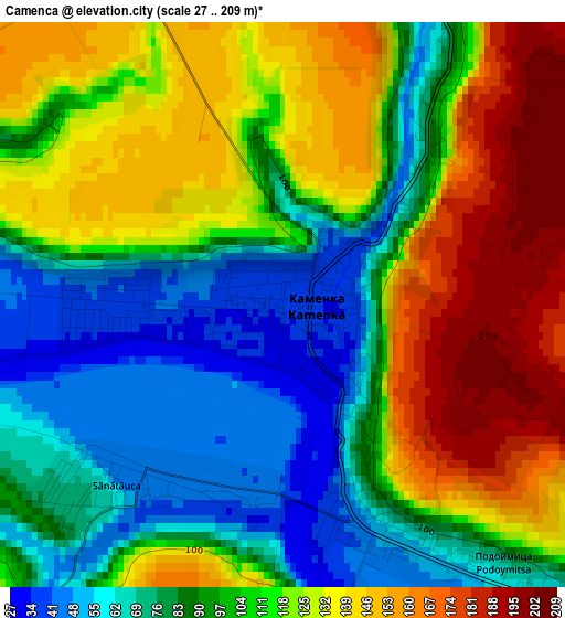
Below is the Elevation map of Camenca, which displays elevation range with different colors. Scale of the first map is from 27 to 209 m (89 to 686 ft) with average elevation of 107.4 meters (=352 ft) [note 1]
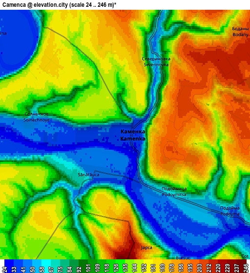
These maps also provides idea of topography and contour of this city, they are displayed at different zoom levels. More info about maps, scale and edge coordinates you can find below images.
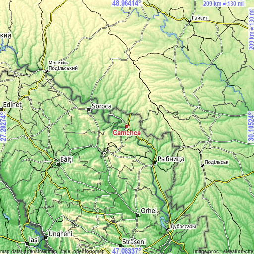
| \ | Map #1 | Map #2 | Topo.Map |
| Scale [m] | 27..209 m | 24..246 m | × |
| Scale [ft] | 89..686 ft | 79..807 ft | × |
| Average | 107.4 m = 352 ft | 122.8 m = 403 ft | × |
| Width | 6.53 km = 4.1 mi | 13.07 km = 8.1 mi | 209.1 km = 129.9 mi |
| Height | 6.53 km = 4.1 mi | 13.07 km = 8.1 mi | 209.1 km = 129.9 mi |
| ↑Max Latitude | 48.061708° | 48.09107° | 48.96414° |
| Latitude at center | 48.03233° | 48.03233° | 48.03233° |
| ↓Min Latitude | 48.002935° | 47.973523° | 47.08337° |
| ← Min Longitude | 28.655045° | 28.611099° | 27.29274° |
| Longitude center | 28.69899° | 28.69899° | 28.69899° |
| →Max Longitude | 28.742935° | 28.786881° | 30.10524° |
Nearby cities:
Cities around Camenca sort by population:
• Rîbniţa elevation 96 m
37.4 km,  141°
141°
• Soroca 191 m
33.7 km,  294°
294°
• Floreşti 120 m
34 km,  242°
242°
• Bilicenii Vechi 121 m
64.2 km,  229°
229°
• Sîngerei 90 m
60.5 km,  223°
223°
• Rezina 138 m
37.2 km,  147°
147°
• Teleneşti 69 m
64.1 km,  202°
202°
• Şoldăneşti 152 m
25.1 km,  163°
163°
• Biruinţa 102 m
52.8 km, 242°
• Mărculeşti 100 m
38.6 km, 241°
• Saharna 48 m
43.2 km, 151°
• Ghindești 116 m
31.1 km, 230°
Multilingual:
 En español:
Camenca elevación 36 m.
 En France:
Camenca élévation 36 m.


Sources and notes:
- [note 1] Map square and city borders are not equal. Map elevation data is calculated only from area inside that square.
- [src 1] Elevation data from geonames database provided with same terms of usage.
- [src 2] The elevation map of Camenca is generated using elevation data from NASA's 3 arcsec (90m) resolution SRTM data.
- [src 3] Base (background) map © OpenStreetMap contributors tiles are generated by Geofabrik and OpenTopoMap.
Copyright & License:
This Camenca Elevation Map is licensed under CC BY-SA. You may reuse any part from this page, if you give a proper credit by linking to this URL:
 More info on terms of use page.