Bni Bouayach elevation
Bni Bouayach (Tanger-Tetouan-Al Hoceima), Morocco elevation is 118 meters and Bni Bouayach elevation in feet is 387 ft above sea level [src 1]. Bni Bouayach is a populated place (feature code) with elevation that is 498 meters (1634 ft) smaller than average city elevation in Morocco.
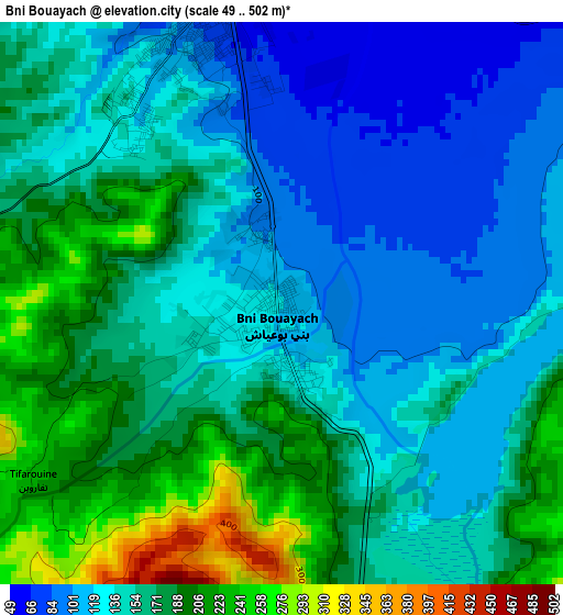
Below is the Elevation map of Bni Bouayach, which displays elevation range with different colors. Scale of the first map is from 49 to 502 m (161 to 1647 ft) with average elevation of 154.2 meters (=506 ft) [note 1]
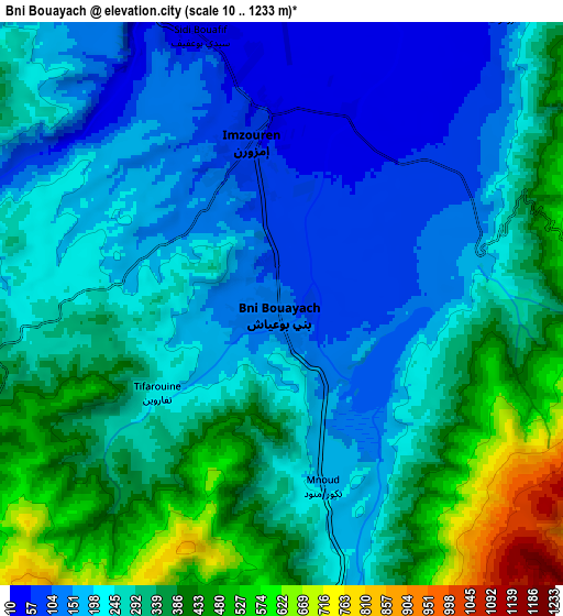
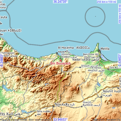
These maps also provides idea of topography and contour of this city, they are displayed at different zoom levels. More info about maps, scale and edge coordinates you can find below images.
| \ | Map #1 | Map #2 | Topo.Map |
| Scale [m] | 49..502 m | 10..1233 m | × |
| Scale [ft] | 161..1647 ft | 33..4045 ft | × |
| Average | 154.2 m = 506 ft | 276.1 m = 906 ft | × |
| Width | 7.99 km = 5 mi | 15.99 km = 9.9 mi | 255.8 km = 158.9 mi |
| Height | 7.99 km = 5 mi | 15.99 km = 9.9 mi | 255.8 km = 158.9 mi |
| ↑Max Latitude | 35.141004° | 35.176932° | 36.24735° |
| Latitude at center | 35.10506° | 35.10506° | 35.10506° |
| ↓Min Latitude | 35.0691° | 35.033125° | 33.94653° |
| ← Min Longitude | -3.884225° | -3.928171° | -5.24653° |
| Longitude center | -3.84028° | -3.84028° | -3.84028° |
| →Max Longitude | -3.796335° | -3.752389° | -2.43403° |
Nearby cities:
Cities around Bni Bouayach sort by population:
• Al Hoceïma elevation 74 m
18.5 km,  331°
331°
• Tirhanimîne 209 m
17.9 km,  324°
324°
• Imzouren 77 m
4.7 km,  348°
348°
• Al Aaroui 177 m
76.3 km,  97°
97°
• Targuist 1029 m
47.4 km,  246°
246°
• Midar 388 m
33.4 km,  123°
123°
• Tiztoutine 198 m
64.3 km, 103°
• Aknoul 1021 m
50.2 km,  182°
182°
• Ajdir 1060 m
42.1 km,  197°
197°
• Senada 290 m
34.3 km,  264°
264°
• Rouadi 399 m
27.2 km,  278°
278°
• Boudinar 239 m
20.5 km,  73°
73°
Multilingual:
 En español:
Bni Bouayach elevación 118 m.
 En France:
Bni Bouayach élévation 118 m.
 Auf Deutsch:
Bni Bouayach höhe über dem Meeresspiegel ist 118 m.

Sources and notes:
- [note 1] Map square and city borders are not equal. Map elevation data is calculated only from area inside that square.
- [src 1] Elevation data from geonames database provided with same terms of usage.
- [src 2] The elevation map of Bni Bouayach is generated using elevation data from NASA's 3 arcsec (90m) resolution SRTM data.
- [src 3] Base (background) map © OpenStreetMap contributors tiles are generated by Geofabrik and OpenTopoMap.
Copyright & License:
This Bni Bouayach Elevation Map is licensed under CC BY-SA. You may reuse any part from this page, if you give a proper credit by linking to this URL:
 More info on terms of use page.