Gueltat Zemmour elevation
Gueltat Zemmour (Laâyoune-Sakia El Hamra, Boujdour), Morocco elevation is 419 meters and Gueltat Zemmour elevation in feet is 1375 ft above sea level [src 1]. Gueltat Zemmour is a populated place (feature code) with elevation that is 197 meters (646 ft) smaller than average city elevation in Morocco.
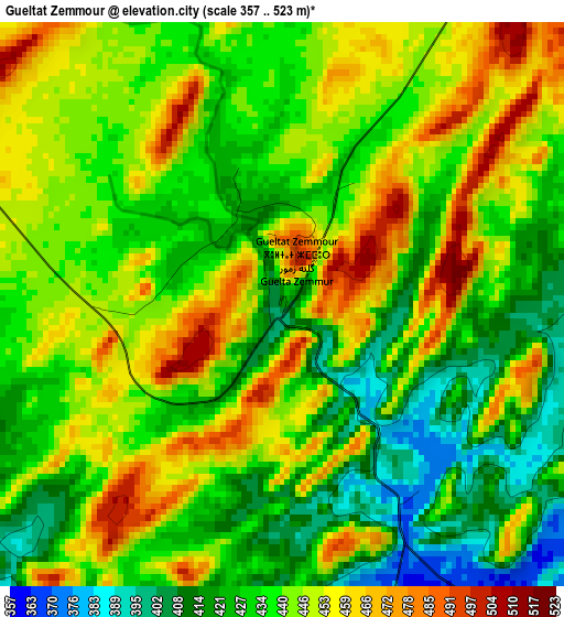
Below is the Elevation map of Gueltat Zemmour, which displays elevation range with different colors. Scale of the first map is from 357 to 523 m (1171 to 1716 ft) with average elevation of 439.7 meters (=1443 ft) [note 1]
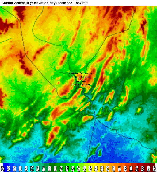
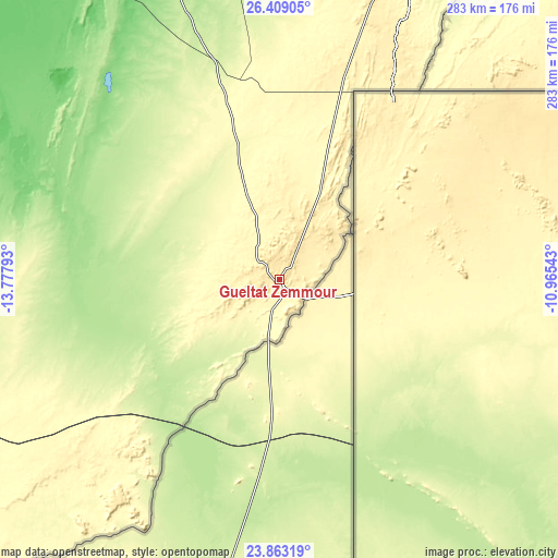
These maps also provides idea of topography and contour of this city, they are displayed at different zoom levels. More info about maps, scale and edge coordinates you can find below images.
| \ | Map #1 | Map #2 | Topo.Map |
| Scale [m] | 357..523 m | 337..537 m | × |
| Scale [ft] | 1171..1716 ft | 1106..1762 ft | × |
| Average | 439.7 m = 1443 ft | 430.4 m = 1412 ft | × |
| Width | 8.85 km = 5.5 mi | 17.69 km = 11 mi | 283.1 km = 175.9 mi |
| Height | 8.85 km = 5.5 mi | 17.69 km = 11 mi | 283.1 km = 175.9 mi |
| ↑Max Latitude | 25.182535° | 25.222297° | 26.40905° |
| Latitude at center | 25.14276° | 25.14276° | 25.14276° |
| ↓Min Latitude | 25.102972° | 25.063171° | 23.86319° |
| ← Min Longitude | -12.415625° | -12.459571° | -13.77793° |
| Longitude center | -12.37168° | -12.37168° | -12.37168° |
| →Max Longitude | -12.327735° | -12.283789° | -10.96543° |
Nearby cities:
Cities around Gueltat Zemmour sort by population:
• Tan-Tan elevation 45 m
387.4 km,  18°
18°
• Smara 188 m
190.7 km, 21°
• Tarfaya 5 m
315.8 km,  349°
349°
• Akhfennir 15 m
329.7 km,  5°
5°
Multilingual:
 En español:
Gueltat Zemmour elevación 419 m.
 En France:
Gueltat Zemmour élévation 419 m.
 Auf Deutsch:
Gueltat Zemmour höhe über dem Meeresspiegel ist 419 m.

Sources and notes:
- [note 1] Map square and city borders are not equal. Map elevation data is calculated only from area inside that square.
- [src 1] Elevation data from geonames database provided with same terms of usage.
- [src 2] The elevation map of Gueltat Zemmour is generated using elevation data from NASA's 3 arcsec (90m) resolution SRTM data.
- [src 3] Base (background) map © OpenStreetMap contributors tiles are generated by Geofabrik and OpenTopoMap.
Copyright & License:
This Gueltat Zemmour Elevation Map is licensed under CC BY-SA. You may reuse any part from this page, if you give a proper credit by linking to this URL:
 More info on terms of use page.