Ahfir elevation
Ahfir (Oriental, Berkane), Morocco elevation is 252 meters and Ahfir elevation in feet is 827 ft above sea level [src 1]. Ahfir is a seat of a third-order administrative division (feature code) with elevation that is 364 meters (1194 ft) smaller than average city elevation in Morocco.
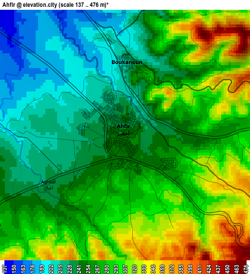
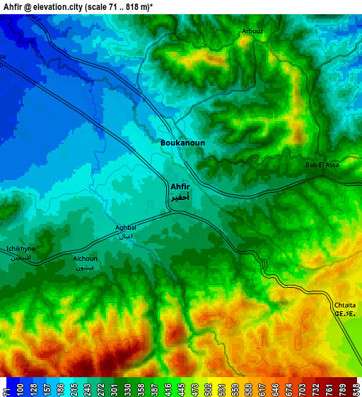
Below is the Elevation map of Ahfir, which displays elevation range with different colors. Scale of the first map is from 137 to 476 m (449 to 1562 ft) with average elevation of 267.7 meters (=878 ft) [note 1]
These maps also provides idea of topography and contour of this city, they are displayed at different zoom levels. More info about maps, scale and edge coordinates you can find below images.
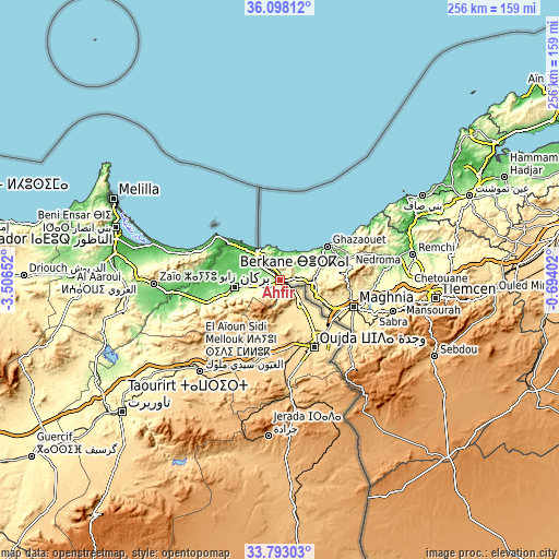
| \ | Map #1 | Map #2 | Topo.Map |
| Scale [m] | 137..476 m | 71..818 m | × |
| Scale [ft] | 449..1562 ft | 233..2684 ft | × |
| Average | 267.7 m = 878 ft | 338.3 m = 1110 ft | × |
| Width | 8.01 km = 5 mi | 16.02 km = 10 mi | 256.3 km = 159.3 mi |
| Height | 8.01 km = 5 mi | 16.02 km = 10 mi | 256.3 km = 159.3 mi |
| ↑Max Latitude | 34.98969° | 35.025685° | 36.09812° |
| Latitude at center | 34.95368° | 34.95368° | 34.95368° |
| ↓Min Latitude | 34.917654° | 34.881612° | 33.79303° |
| ← Min Longitude | -2.144215° | -2.188161° | -3.50652° |
| Longitude center | -2.10027° | -2.10027° | -2.10027° |
| →Max Longitude | -2.056325° | -2.012379° | -0.69402° |
Nearby cities:
Cities around Ahfir sort by population:
• Oujda-Angad elevation 549 m
35 km,  149°
149°
• Berkane 173 m
20.4 km,  259°
259°
• El Aïoun 604 m
55.4 km,  221°
221°
• Zaïo 198 m
57.7 km,  268°
268°
• Saidia 4 m
18.5 km,  320°
320°
• Mosquée 799 m
32.9 km,  240°
240°
• Hassi Berkane 393 m
71.1 km, 259°
• Tiouli 1101 m
69.6 km,  159°
159°
• Kariat Arkmane 3 m
61.3 km,  286°
286°
• Guenfouda 818 m
52.5 km,  174°
174°
• Rislane 1020 m
38.7 km, 238°
• Madagh 76 m
22.5 km, 286°
Multilingual:
 En español:
Ahfir elevación 252 m.
 En France:
Ahfir élévation 252 m.


Sources and notes:
- [note 1] Map square and city borders are not equal. Map elevation data is calculated only from area inside that square.
- [src 1] Elevation data from geonames database provided with same terms of usage.
- [src 2] The elevation map of Ahfir is generated using elevation data from NASA's 3 arcsec (90m) resolution SRTM data.
- [src 3] Base (background) map © OpenStreetMap contributors tiles are generated by Geofabrik and OpenTopoMap.
Copyright & License:
This Ahfir Elevation Map is licensed under CC BY-SA. You may reuse any part from this page, if you give a proper credit by linking to this URL:
 More info on terms of use page.