Aoulouz elevation
Aoulouz (Souss-Massa, Taroudannt), Morocco elevation is 674 meters and Aoulouz elevation in feet is 2211 ft above sea level [src 1]. Aoulouz is a seat of a third-order administrative division (feature code) with elevation that is 58 meters (190 ft) bigger than average city elevation in Morocco.
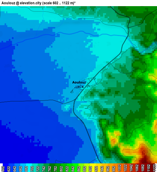
Below is the Elevation map of Aoulouz, which displays elevation range with different colors. Scale of the first map is from 602 to 1122 m (1975 to 3681 ft) with average elevation of 700.5 meters (=2298 ft) [note 1]
These maps also provides idea of topography and contour of this city, they are displayed at different zoom levels. More info about maps, scale and edge coordinates you can find below images.
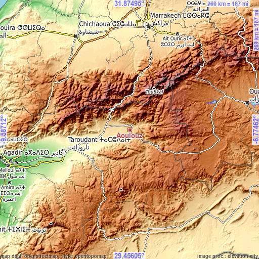
| \ | Map #1 | Topo.Map |
| Scale [m] | 602..1122 m | × |
| Scale [ft] | 1975..3681 ft | × |
| Average | 700.5 m = 2298 ft | × |
| Width | 8.41 km = 5.2 mi | 269 km = 167.1 mi |
| Height | 8.41 km = 5.2 mi | 269 km = 167.1 mi |
| ↑Max Latitude | 30.71086° | 31.87495° |
| Latitude at center | 30.67307° | 30.67307° |
| ↓Min Latitude | 30.635266° | 29.45605° |
| ← Min Longitude | -8.224815° | -9.58712° |
| Longitude center | -8.18087° | -8.18087° |
| →Max Longitude | -8.136925° | -6.77462° |
Nearby cities:
Cities around Aoulouz sort by population:
• Oukaïmedene elevation 2637 m
66.7 km,  27°
27°
• Tizguine 1097 m
63.1 km,  348°
348°
• Agadir Melloul 1766 m
62 km,  143°
143°
• Adar 1697 m
61.9 km,  197°
197°
• Amizmiz 979 m
60.6 km,  355°
355°
• Tiout 462 m
58.6 km,  237°
237°
• Adassil 1199 m
56.7 km,  328°
328°
• Azgour 1595 m
53.2 km, 346°
• Arazane 357 m
44.9 km,  245°
245°
• Iguidi 1218 m
32.3 km,  55°
55°
• Taliouine 1007 m
30.3 km,  121°
121°
• Zawit Al Bour 691 m
0.7 km,  73°
73°
Multilingual:
 En español:
Aoulouz elevación 674 m.
 En France:
Aoulouz élévation 674 m.


Sources and notes:
- [note 1] Map square and city borders are not equal. Map elevation data is calculated only from area inside that square.
- [src 1] Elevation data from geonames database provided with same terms of usage.
- [src 2] The elevation map of Aoulouz is generated using elevation data from NASA's 3 arcsec (90m) resolution SRTM data.
- [src 3] Base (background) map © OpenStreetMap contributors tiles are generated by Geofabrik and OpenTopoMap.
Copyright & License:
This Aoulouz Elevation Map is licensed under CC BY-SA. You may reuse any part from this page, if you give a proper credit by linking to this URL:
 More info on terms of use page.