Demnate elevation
Demnate (Béni Mellal-Khénifra, Azilal Province), Morocco elevation is 927 meters and Demnate elevation in feet is 3041 ft above sea level [src 1]. Demnate is a seat of a third-order administrative division (feature code) with elevation that is 311 meters (1020 ft) bigger than average city elevation in Morocco.
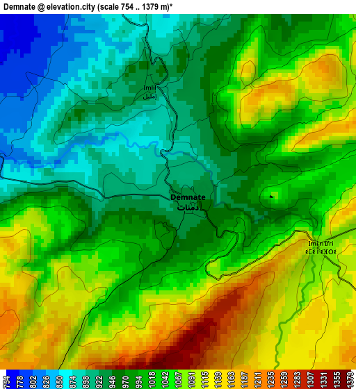
Below is the Elevation map of Demnate, which displays elevation range with different colors. Scale of the first map is from 754 to 1379 m (2474 to 4524 ft) with average elevation of 1018.5 meters (=3342 ft) [note 1]
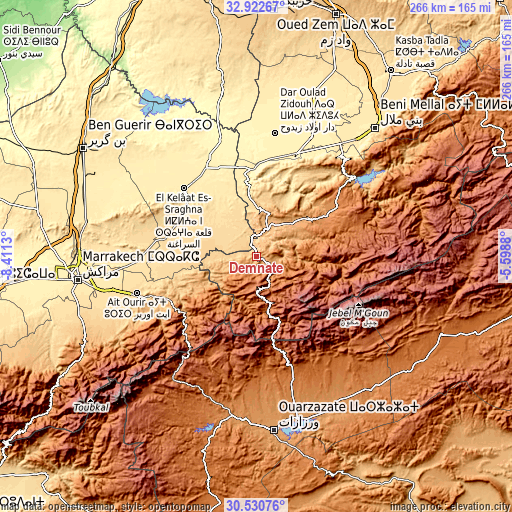
These maps also provides idea of topography and contour of this city, they are displayed at different zoom levels. More info about maps, scale and edge coordinates you can find below images.
| \ | Map #1 | Topo.Map |
| Scale [m] | 754..1379 m | × |
| Scale [ft] | 2474..4524 ft | × |
| Average | 1018.5 m = 3342 ft | × |
| Width | 8.31 km = 5.2 mi | 266 km = 165.3 mi |
| Height | 8.31 km = 5.2 mi | 266 km = 165.3 mi |
| ↑Max Latitude | 31.771798° | 32.92267° |
| Latitude at center | 31.73443° | 31.73443° |
| ↓Min Latitude | 31.697047° | 30.53076° |
| ← Min Longitude | -7.048995° | -8.4113° |
| Longitude center | -7.00505° | -7.00505° |
| →Max Longitude | -6.961105° | -5.5988° |
Nearby cities:
Cities around Demnate sort by population:
• Oulad Ayad elevation 450 m
55.3 km,  20°
20°
• Taounza 681 m
54.9 km,  43°
43°
• Telouet 1784 m
54.2 km,  204°
204°
• Touama 950 m
51.2 km,  244°
244°
• Zerkten 1193 m
48.8 km,  228°
228°
• Azilal 1357 m
48.1 km,  58°
58°
• Sidi Rahhal 695 m
45.2 km,  258°
258°
• Bzou 455 m
39.9 km,  354°
354°
• Tabia 561 m
38.2 km,  30°
30°
• Abadou 1111 m
33.9 km, 239°
• Ouaoula 1237 m
28.4 km, 57°
• Tifni 1417 m
13.3 km,  152°
152°
Multilingual:
 En español:
Demnate elevación 927 m.
 En France:
Demnate élévation 927 m.


Sources and notes:
- [note 1] Map square and city borders are not equal. Map elevation data is calculated only from area inside that square.
- [src 1] Elevation data from geonames database provided with same terms of usage.
- [src 2] The elevation map of Demnate is generated using elevation data from NASA's 3 arcsec (90m) resolution SRTM data.
- [src 3] Base (background) map © OpenStreetMap contributors tiles are generated by Geofabrik and OpenTopoMap.
Copyright & License:
This Demnate Elevation Map is licensed under CC BY-SA. You may reuse any part from this page, if you give a proper credit by linking to this URL:
 More info on terms of use page.