Essaouira elevation
Essaouira (Marrakesh-Safi), Morocco elevation is 7 meters and Essaouira elevation in feet is 23 ft above sea level [src 1]. Essaouira is a seat of a third-order administrative division (feature code) with elevation that is 609 meters (1998 ft) smaller than average city elevation in Morocco.
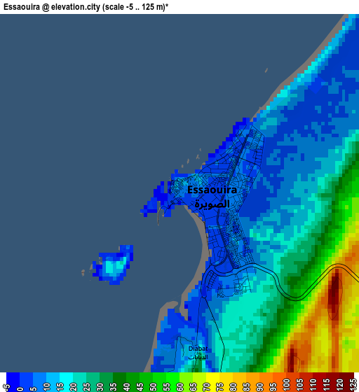
Below is the Elevation map of Essaouira, which displays elevation range with different colors. Scale of the first map is from -5 to 125 m (-16 to 410 ft) with average elevation of 24 meters (=79 ft) [note 1]
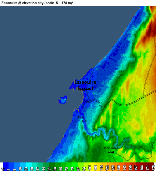
These maps also provides idea of topography and contour of this city, they are displayed at different zoom levels. More info about maps, scale and edge coordinates you can find below images.
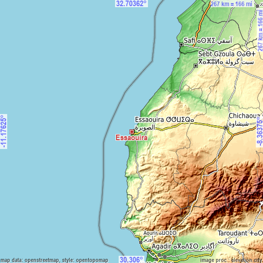
| \ | Map #1 | Map #2 | Topo.Map |
| Scale [m] | -5..125 m | -5..178 m | × |
| Scale [ft] | -16..410 ft | -16..584 ft | × |
| Average | 24 m = 79 ft | 61.7 m = 202 ft | × |
| Width | 8.33 km = 5.2 mi | 16.66 km = 10.4 mi | 266.6 km = 165.7 mi |
| Height | 8.33 km = 5.2 mi | 16.66 km = 10.4 mi | 266.6 km = 165.7 mi |
| ↑Max Latitude | 31.549957° | 31.587399° | 32.70362° |
| Latitude at center | 31.5125° | 31.5125° | 31.5125° |
| ↓Min Latitude | 31.475028° | 31.437541° | 30.306° |
| ← Min Longitude | -9.813945° | -9.857891° | -11.17625° |
| Longitude center | -9.77° | -9.77° | -9.77° |
| →Max Longitude | -9.726055° | -9.682109° | -8.36375° |
Nearby cities:
Cities around Essaouira sort by population:
• Safi elevation 45 m
100.9 km,  29°
29°
• Bigoudine 741 m
102.6 km,  148°
148°
• Argana 768 m
102.1 km,  142°
142°
• Timezgadiouine 917 m
98.2 km, 135°
• Chichaoua 356 m
95.5 km,  87°
87°
• Tamri 14 m
91 km,  183°
183°
• Tadrart 900 m
87.2 km,  160°
160°
• Taouloukoult 1043 m
73.1 km,  116°
116°
• Bouabout 894 m
62.5 km, 116°
• Tamanar 320 m
57.6 km,  171°
171°
• Talmest 182 m
53.2 km,  51°
51°
• Smimou 271 m
34.1 km, 170°
Multilingual:
 En español:
Esauira elevación 7 m.
 En France:
Essaouira élévation 7 m.
 Auf Deutsch:
Essaouira, as-Ṣawīra höhe über dem Meeresspiegel ist 7 m.

Sources and notes:
- [note 1] Map square and city borders are not equal. Map elevation data is calculated only from area inside that square.
- [src 1] Elevation data from geonames database provided with same terms of usage.
- [src 2] The elevation map of Essaouira is generated using elevation data from NASA's 3 arcsec (90m) resolution SRTM data.
- [src 3] Base (background) map © OpenStreetMap contributors tiles are generated by Geofabrik and OpenTopoMap.
Copyright & License:
This Essaouira Elevation Map is licensed under CC BY-SA. You may reuse any part from this page, if you give a proper credit by linking to this URL:
 More info on terms of use page.