Nador elevation
Nador (Oriental), Morocco elevation is 19 meters and Nador elevation in feet is 62 ft above sea level [src 1]. Nador is a seat of a third-order administrative division (feature code) with elevation that is 597 meters (1959 ft) smaller than average city elevation in Morocco.
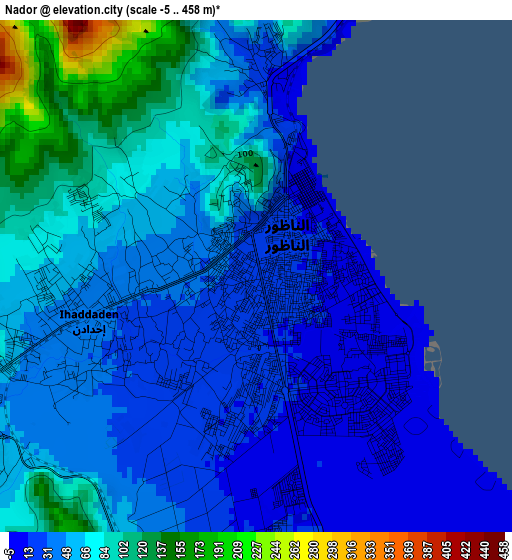
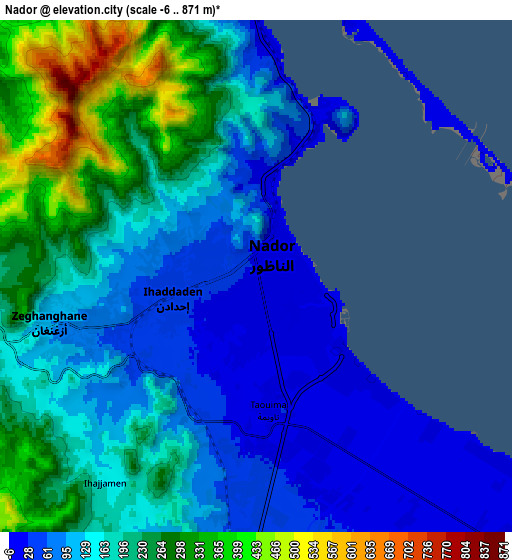
Below is the Elevation map of Nador, which displays elevation range with different colors. Scale of the first map is from -5 to 458 m (-16 to 1503 ft) with average elevation of 54.2 meters (=178 ft) [note 1]
These maps also provides idea of topography and contour of this city, they are displayed at different zoom levels. More info about maps, scale and edge coordinates you can find below images.
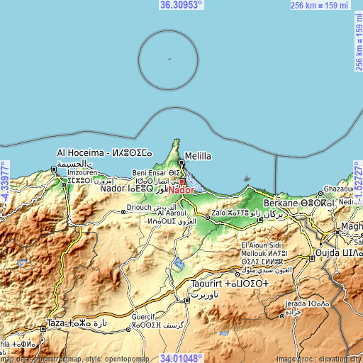
| \ | Map #1 | Map #2 | Topo.Map |
| Scale [m] | -5..458 m | -6..871 m | × |
| Scale [ft] | -16..1503 ft | -20..2858 ft | × |
| Average | 54.2 m = 178 ft | 166.8 m = 547 ft | × |
| Width | 7.99 km = 5 mi | 15.98 km = 9.9 mi | 255.6 km = 158.8 mi |
| Height | 7.99 km = 5 mi | 15.98 km = 9.9 mi | 255.6 km = 158.8 mi |
| ↑Max Latitude | 35.204046° | 35.239946° | 36.30953° |
| Latitude at center | 35.16813° | 35.16813° | 35.16813° |
| ↓Min Latitude | 35.132198° | 35.096251° | 34.01048° |
| ← Min Longitude | -2.977465° | -3.021411° | -4.33977° |
| Longitude center | -2.93352° | -2.93352° | -2.93352° |
| →Max Longitude | -2.889575° | -2.845629° | -1.52727° |
Nearby cities:
Cities around Nador sort by population:
• Berkane elevation 173 m
62.3 km,  116°
116°
• Al Aaroui 177 m
18.8 km,  201°
201°
• Zaïo 198 m
31 km,  143°
143°
• Midar 388 m
60.2 km,  245°
245°
• Mosquée 799 m
62.2 km,  130°
130°
• Rislane 1020 m
61.8 km, 135°
• Madagh 76 m
57 km,  107°
107°
• Hassi Berkane 393 m
37.1 km,  170°
170°
• Tiztoutine 198 m
29.6 km,  222°
222°
• Kariat Arkmane 3 m
18.3 km, 111°
• Selouane 80 m
10.6 km,  184°
184°
• Taouima 17 m
4.3 km, 173°
Multilingual:
 En español:
Nador elevación 19 m.
 En France:
Nador élévation 19 m.


Sources and notes:
- [note 1] Map square and city borders are not equal. Map elevation data is calculated only from area inside that square.
- [src 1] Elevation data from geonames database provided with same terms of usage.
- [src 2] The elevation map of Nador is generated using elevation data from NASA's 3 arcsec (90m) resolution SRTM data.
- [src 3] Base (background) map © OpenStreetMap contributors tiles are generated by Geofabrik and OpenTopoMap.
Copyright & License:
This Nador Elevation Map is licensed under CC BY-SA. You may reuse any part from this page, if you give a proper credit by linking to this URL:
 More info on terms of use page.