Ghouazi elevation
Ghouazi (Fès-Meknès, Taounate), Morocco elevation is 77 meters and Ghouazi elevation in feet is 253 ft above sea level [src 1]. Ghouazi is a seat of a third-order administrative division (feature code) with elevation that is 539 meters (1768 ft) smaller than average city elevation in Morocco.
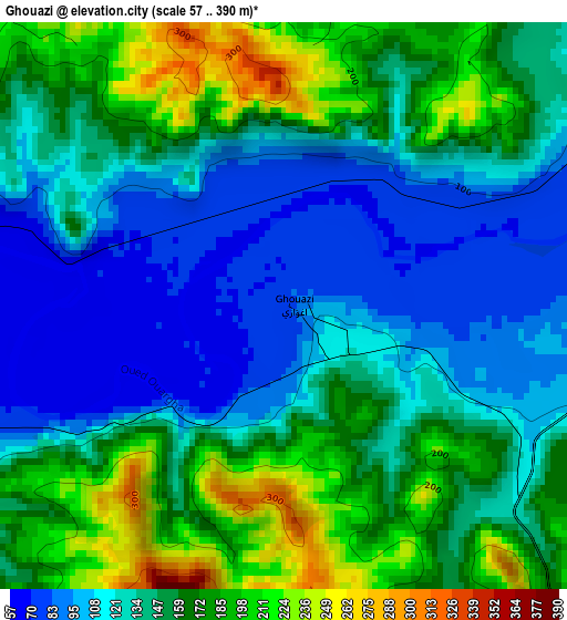
Below is the Elevation map of Ghouazi, which displays elevation range with different colors. Scale of the first map is from 57 to 390 m (187 to 1280 ft) with average elevation of 144.1 meters (=473 ft) [note 1]
These maps also provides idea of topography and contour of this city, they are displayed at different zoom levels. More info about maps, scale and edge coordinates you can find below images.
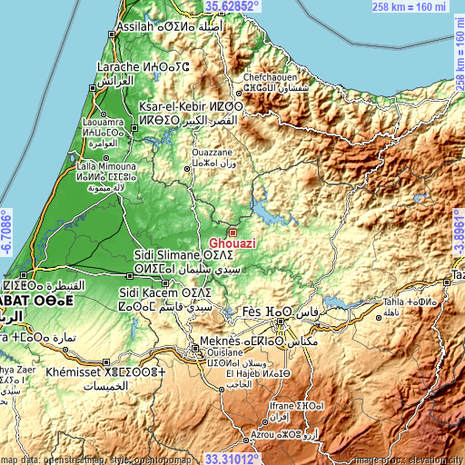
| \ | Map #1 | Topo.Map |
| Scale [m] | 57..390 m | × |
| Scale [ft] | 187..1280 ft | × |
| Average | 144.1 m = 473 ft | × |
| Width | 8.06 km = 5 mi | 257.8 km = 160.2 mi |
| Height | 8.06 km = 5 mi | 257.8 km = 160.2 mi |
| ↑Max Latitude | 34.513588° | 35.62852° |
| Latitude at center | 34.47737° | 34.47737° |
| ↓Min Latitude | 34.441136° | 33.31012° |
| ← Min Longitude | -5.346295° | -6.7086° |
| Longitude center | -5.30235° | -5.30235° |
| →Max Longitude | -5.258405° | -3.8961° |
Nearby cities:
Cities around Ghouazi sort by population:
• Ouezzane elevation 306 m
43.5 km,  324°
324°
• Galaz 243 m
46.3 km,  80°
80°
• Moulay Yacoub 254 m
44.7 km,  165°
165°
• Had Kourt 138 m
43 km,  291°
291°
• Zoumi 369 m
36.4 km,  353°
353°
• Ourtzagh 178 m
31.2 km, 78°
• Tabouda 466 m
30.7 km,  28°
28°
• Sidi Redouane 199 m
26.7 km,  330°
330°
• Teroual 426 m
22.1 km,  6°
6°
• Moulay Bouchta 353 m
15.8 km,  85°
85°
• Karia Ba Mohamed 160 m
14.4 km,  145°
145°
• Sidi Bousber 305 m
11 km, 330°
Multilingual:
 En español:
Ghouazi elevación 77 m.
 En France:
Ghouazi élévation 77 m.


Sources and notes:
- [note 1] Map square and city borders are not equal. Map elevation data is calculated only from area inside that square.
- [src 1] Elevation data from geonames database provided with same terms of usage.
- [src 2] The elevation map of Ghouazi is generated using elevation data from NASA's 3 arcsec (90m) resolution SRTM data.
- [src 3] Base (background) map © OpenStreetMap contributors tiles are generated by Geofabrik and OpenTopoMap.
Copyright & License:
This Ghouazi Elevation Map is licensed under CC BY-SA. You may reuse any part from this page, if you give a proper credit by linking to this URL:
 More info on terms of use page.