Souq Larb’a al Gharb elevation
Souq Larb’a al Gharb (Rabat-Salé-Kénitra, Kenitra Province), Morocco elevation is 37 meters and Souq Larb’a al Gharb elevation in feet is 121 ft above sea level [src 1]. Souq Larb’a al Gharb is a seat of a third-order administrative division (feature code) with elevation that is 579 meters (1900 ft) smaller than average city elevation in Morocco.
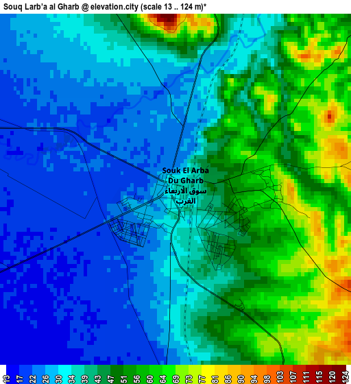
Below is the Elevation map of Souq Larb’a al Gharb, which displays elevation range with different colors. Scale of the first map is from 13 to 124 m (43 to 407 ft) with average elevation of 39.7 meters (=130 ft) [note 1]
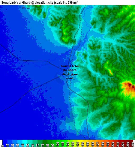
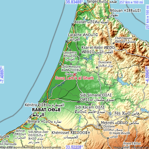
These maps also provides idea of topography and contour of this city, they are displayed at different zoom levels. More info about maps, scale and edge coordinates you can find below images.
| \ | Map #1 | Map #2 | Topo.Map |
| Scale [m] | 13..124 m | 8..239 m | × |
| Scale [ft] | 43..407 ft | 26..784 ft | × |
| Average | 39.7 m = 130 ft | 46.3 m = 152 ft | × |
| Width | 8.04 km = 5 mi | 16.07 km = 10 mi | 257.1 km = 159.8 mi |
| Height | 8.04 km = 5 mi | 16.07 km = 10 mi | 257.1 km = 159.8 mi |
| ↑Max Latitude | 34.722767° | 34.758879° | 35.83485° |
| Latitude at center | 34.68664° | 34.68664° | 34.68664° |
| ↓Min Latitude | 34.650497° | 34.614338° | 33.52228° |
| ← Min Longitude | -6.046665° | -6.090611° | -7.40897° |
| Longitude center | -6.00272° | -6.00272° | -6.00272° |
| →Max Longitude | -5.958775° | -5.914829° | -4.59647° |
Nearby cities:
Cities around Souq Larb’a al Gharb sort by population:
• Larache elevation 38 m
58 km,  346°
346°
• Ksar El Kebir 18 m
36 km,  14°
14°
• Sidi Slimane 37 m
47.4 km,  171°
171°
• Sidi Qacem 83 m
58.4 km,  152°
152°
• Ouezzane 306 m
40.6 km,  72°
72°
• Sidi Yahia El Gharb 18 m
50.6 km,  213°
213°
• Mechraa Bel Ksiri 20 m
13.3 km,  161°
161°
• Sidi Redouane 199 m
51 km,  89°
89°
• Brikcha 307 m
50.1 km,  51°
51°
• Had Kourt 138 m
25.3 km,  108°
108°
• Arbaoua 143 m
24.5 km, 11°
• Lalla Mimouna 38 m
18.7 km,  341°
341°
Multilingual:
 En español:
Souq Larb’a al Gharb elevación 37 m.
 En France:
Souq Larb’a al Gharb élévation 37 m.
 Auf Deutsch:
Souq Larb’a al Gharb höhe über dem Meeresspiegel ist 37 m.
 На русском:
Souq Larb’a al Gharb высота над уровнем моря 37 м
Sources and notes:
- [note 1] Map square and city borders are not equal. Map elevation data is calculated only from area inside that square.
- [src 1] Elevation data from geonames database provided with same terms of usage.
- [src 2] The elevation map of Souq Larb’a al Gharb is generated using elevation data from NASA's 3 arcsec (90m) resolution SRTM data.
- [src 3] Base (background) map © OpenStreetMap contributors tiles are generated by Geofabrik and OpenTopoMap.
Copyright & License:
This Souq Larb’a al Gharb Elevation Map is licensed under CC BY-SA. You may reuse any part from this page, if you give a proper credit by linking to this URL:
 More info on terms of use page.