Taounate elevation
Taounate (Fès-Meknès), Morocco elevation is 600 meters and Taounate elevation in feet is 1969 ft above sea level [src 1]. Taounate is a seat of a third-order administrative division (feature code) with elevation that is 16 meters (52 ft) smaller than average city elevation in Morocco.
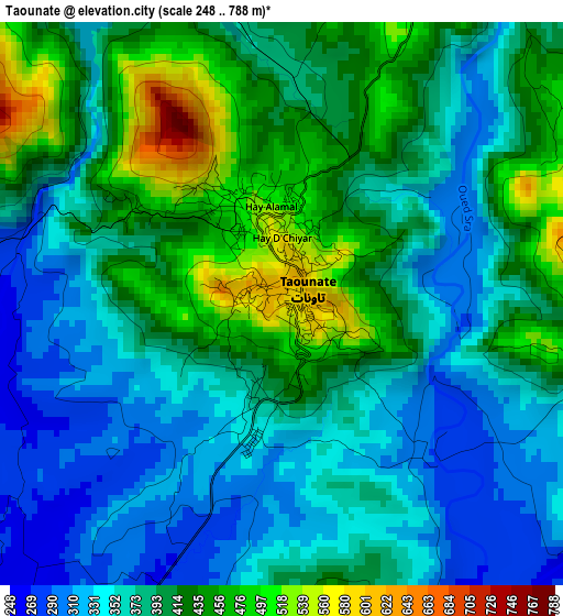
Below is the Elevation map of Taounate, which displays elevation range with different colors. Scale of the first map is from 248 to 788 m (814 to 2585 ft) with average elevation of 389.3 meters (=1277 ft) [note 1]
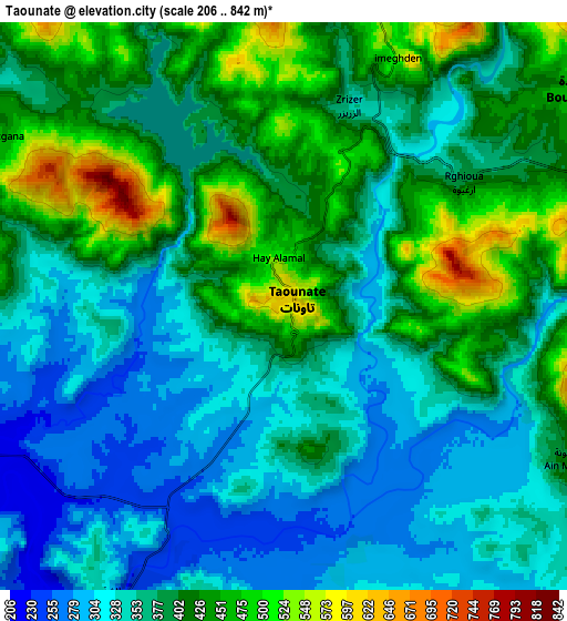
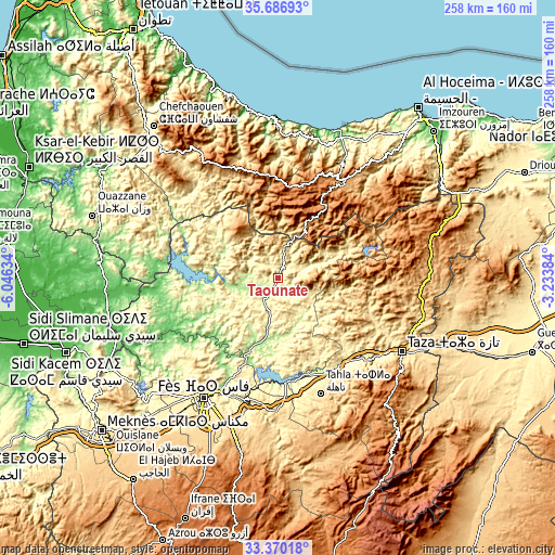
These maps also provides idea of topography and contour of this city, they are displayed at different zoom levels. More info about maps, scale and edge coordinates you can find below images.
| \ | Map #1 | Map #2 | Topo.Map |
| Scale [m] | 248..788 m | 206..842 m | × |
| Scale [ft] | 814..2585 ft | 676..2762 ft | × |
| Average | 389.3 m = 1277 ft | 381.8 m = 1253 ft | × |
| Width | 8.05 km = 5 mi | 16.1 km = 10 mi | 257.6 km = 160.1 mi |
| Height | 8.05 km = 5 mi | 16.1 km = 10 mi | 257.6 km = 160.1 mi |
| ↑Max Latitude | 34.572803° | 34.60898° | 35.68693° |
| Latitude at center | 34.53661° | 34.53661° | 34.53661° |
| ↓Min Latitude | 34.500402° | 34.464177° | 33.37018° |
| ← Min Longitude | -4.684035° | -4.727981° | -6.04634° |
| Longitude center | -4.64009° | -4.64009° | -4.64009° |
| →Max Longitude | -4.596145° | -4.552199° | -3.23384° |
Nearby cities:
Cities around Taounate sort by population:
• Tabouda elevation 466 m
50.1 km,  293°
293°
• Oued Amlil 301 m
49.9 km,  138°
138°
• Matmata 306 m
49.3 km,  170°
170°
• Tamorot 979 m
46.2 km,  344°
344°
• Moulay Bouchta 353 m
45.2 km,  263°
263°
• Ratba 590 m
38.3 km,  314°
314°
• Ourtzagh 178 m
30.1 km,  269°
269°
• Tissa 214 m
27.7 km,  184°
184°
• Bouarouss 247 m
25.1 km,  218°
218°
• Oulad Daoud 362 m
15.5 km,  198°
198°
• Galaz 243 m
15 km, 273°
• Timezgana 454 m
9.5 km,  300°
300°
Multilingual:
 En español:
Taounate elevación 600 m.
 En France:
Taounate élévation 600 m.
 Auf Deutsch:
Taounate höhe über dem Meeresspiegel ist 600 m.

Sources and notes:
- [note 1] Map square and city borders are not equal. Map elevation data is calculated only from area inside that square.
- [src 1] Elevation data from geonames database provided with same terms of usage.
- [src 2] The elevation map of Taounate is generated using elevation data from NASA's 3 arcsec (90m) resolution SRTM data.
- [src 3] Base (background) map © OpenStreetMap contributors tiles are generated by Geofabrik and OpenTopoMap.
Copyright & License:
This Taounate Elevation Map is licensed under CC BY-SA. You may reuse any part from this page, if you give a proper credit by linking to this URL:
 More info on terms of use page.