Tiflet elevation
Tiflet (Rabat-Salé-Kénitra, Khemisset), Morocco elevation is 340 meters and Tiflet elevation in feet is 1115 ft above sea level [src 1]. Tiflet is a seat of a third-order administrative division (feature code) with elevation that is 276 meters (906 ft) smaller than average city elevation in Morocco.
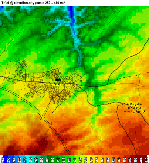
Below is the Elevation map of Tiflet, which displays elevation range with different colors. Scale of the first map is from 252 to 410 m (827 to 1345 ft) with average elevation of 340.8 meters (=1118 ft) [note 1]
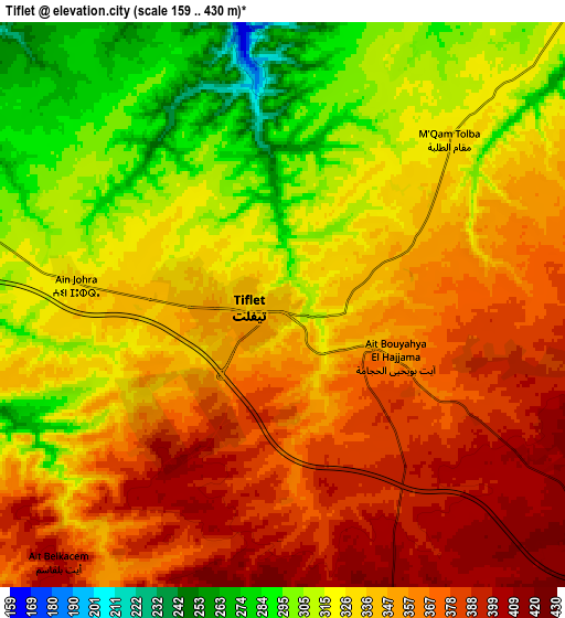
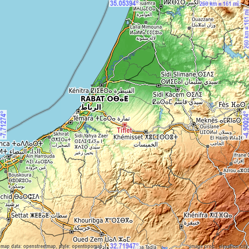
These maps also provides idea of topography and contour of this city, they are displayed at different zoom levels. More info about maps, scale and edge coordinates you can find below images.
| \ | Map #1 | Map #2 | Topo.Map |
| Scale [m] | 252..410 m | 159..430 m | × |
| Scale [ft] | 827..1345 ft | 522..1411 ft | × |
| Average | 340.8 m = 1118 ft | 340.4 m = 1117 ft | × |
| Width | 8.11 km = 5 mi | 16.22 km = 10.1 mi | 259.6 km = 161.3 mi |
| Height | 8.11 km = 5 mi | 16.22 km = 10.1 mi | 259.6 km = 161.3 mi |
| ↑Max Latitude | 33.93116° | 33.967614° | 35.05394° |
| Latitude at center | 33.89469° | 33.89469° | 33.89469° |
| ↓Min Latitude | 33.858205° | 33.821704° | 32.71947° |
| ← Min Longitude | -6.350435° | -6.394381° | -7.71274° |
| Longitude center | -6.30649° | -6.30649° | -6.30649° |
| →Max Longitude | -6.262545° | -6.218599° | -4.90024° |
Nearby cities:
Cities around Tiflet sort by population:
• Rabat elevation 46 m
50.3 km,  285°
285°
• Sale 34 m
48.7 km, 291°
• Meknès 531 m
70.1 km,  90°
90°
• Kenitra 13 m
47.9 km,  328°
328°
• Temara 73 m
55.5 km,  273°
273°
• Khemisset 451 m
23.5 km,  109°
109°
• Sidi Slimane 37 m
54 km,  40°
40°
• Sidi Qacem 83 m
66 km,  56°
56°
• Skhirate 51 m
67.1 km, 266°
• Sidi Yahia El Gharb 18 m
45.6 km,  0°
0°
• Oulmes 1175 m
59.3 km,  151°
151°
• Ezzhiliga 718 m
69.3 km,  197°
197°
Multilingual:
 En español:
Tiflet elevación 340 m.
 En France:
Tiflet élévation 340 m.


Sources and notes:
- [note 1] Map square and city borders are not equal. Map elevation data is calculated only from area inside that square.
- [src 1] Elevation data from geonames database provided with same terms of usage.
- [src 2] The elevation map of Tiflet is generated using elevation data from NASA's 3 arcsec (90m) resolution SRTM data.
- [src 3] Base (background) map © OpenStreetMap contributors tiles are generated by Geofabrik and OpenTopoMap.
Copyright & License:
This Tiflet Elevation Map is licensed under CC BY-SA. You may reuse any part from this page, if you give a proper credit by linking to this URL:
 More info on terms of use page.