Youssoufia elevation
Youssoufia (Marrakesh-Safi, Safi), Morocco elevation is 302 meters and Youssoufia elevation in feet is 991 ft above sea level [src 1]. Youssoufia is a seat of a third-order administrative division (feature code) with elevation that is 314 meters (1030 ft) smaller than average city elevation in Morocco.
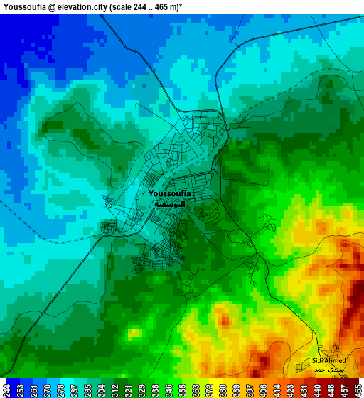
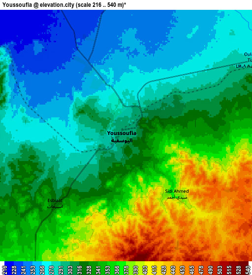
Below is the Elevation map of Youssoufia, which displays elevation range with different colors. Scale of the first map is from 244 to 465 m (801 to 1526 ft) with average elevation of 312.1 meters (=1024 ft) [note 1]
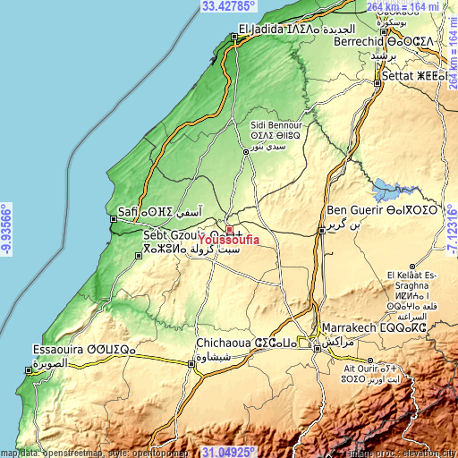
These maps also provides idea of topography and contour of this city, they are displayed at different zoom levels. More info about maps, scale and edge coordinates you can find below images.
| \ | Map #1 | Map #2 | Topo.Map |
| Scale [m] | 244..465 m | 216..540 m | × |
| Scale [ft] | 801..1526 ft | 709..1772 ft | × |
| Average | 312.1 m = 1024 ft | 326.1 m = 1070 ft | × |
| Width | 8.27 km = 5.1 mi | 16.53 km = 10.3 mi | 264.5 km = 164.4 mi |
| Height | 8.27 km = 5.1 mi | 16.53 km = 10.3 mi | 264.5 km = 164.4 mi |
| ↑Max Latitude | 32.2835° | 32.320644° | 33.42785° |
| Latitude at center | 32.24634° | 32.24634° | 32.24634° |
| ↓Min Latitude | 32.209165° | 32.171975° | 31.04925° |
| ← Min Longitude | -8.573355° | -8.617301° | -9.93566° |
| Longitude center | -8.52941° | -8.52941° | -8.52941° |
| →Max Longitude | -8.485465° | -8.441519° | -7.12316° |
Nearby cities:
Cities around Youssoufia sort by population:
• Marrakesh elevation 457 m
84.4 km,  143°
143°
• Safi 45 m
66.8 km,  275°
275°
• Sidi Bennour 182 m
46.1 km,  11°
11°
• Oualidia 51 m
71.7 km,  319°
319°
• Sidi Smai’il 151 m
64.3 km,  1°
1°
• Sidi Abdallah Ghiat 581 m
103.9 km, 140°
• Talmest 182 m
89.7 km,  237°
237°
• Oulad Frej 127 m
84.2 km,  19°
19°
• Boulaouane 179 m
81.4 km,  33°
33°
• Chichaoua 356 m
81.2 km,  195°
195°
• Sidi Abdallah 408 m
72.9 km,  63°
63°
• Sidi Bou Othmane 513 m
67.3 km,  124°
124°
Multilingual:
 En español:
Youssoufia elevación 302 m.
 En France:
Youssoufia élévation 302 m.
 Auf Deutsch:
Youssoufia höhe über dem Meeresspiegel ist 302 m.

Sources and notes:
- [note 1] Map square and city borders are not equal. Map elevation data is calculated only from area inside that square.
- [src 1] Elevation data from geonames database provided with same terms of usage.
- [src 2] The elevation map of Youssoufia is generated using elevation data from NASA's 3 arcsec (90m) resolution SRTM data.
- [src 3] Base (background) map © OpenStreetMap contributors tiles are generated by Geofabrik and OpenTopoMap.
Copyright & License:
This Youssoufia Elevation Map is licensed under CC BY-SA. You may reuse any part from this page, if you give a proper credit by linking to this URL:
 More info on terms of use page.