Setti Fatma elevation
Setti Fatma (Marrakesh-Safi), Morocco elevation is 1434 meters and Setti Fatma elevation in feet is 4705 ft above sea level [src 1]. Setti Fatma is a populated place (feature code) with elevation that is 818 meters (2684 ft) bigger than average city elevation in Morocco.
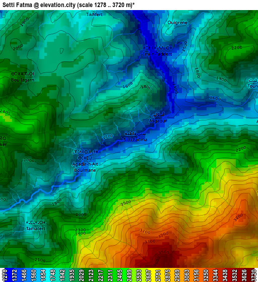
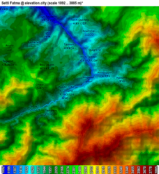
Below is the Elevation map of Setti Fatma, which displays elevation range with different colors. Scale of the first map is from 1278 to 3720 m (4193 to 12205 ft) with average elevation of 2097.1 meters (=6880 ft) [note 1]
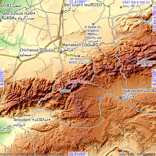
These maps also provides idea of topography and contour of this city, they are displayed at different zoom levels. More info about maps, scale and edge coordinates you can find below images.
| \ | Map #1 | Map #2 | Topo.Map |
| Scale [m] | 1278..3720 m | 1092..3885 m | × |
| Scale [ft] | 4193..12205 ft | 3583..12746 ft | × |
| Average | 2097.1 m = 6880 ft | 2330.3 m = 7645 ft | × |
| Width | 8.36 km = 5.2 mi | 16.71 km = 10.4 mi | 267.4 km = 166.2 mi |
| Height | 8.36 km = 5.2 mi | 16.71 km = 10.4 mi | 267.4 km = 166.2 mi |
| ↑Max Latitude | 31.262652° | 31.300209° | 32.41991° |
| Latitude at center | 31.22508° | 31.22508° | 31.22508° |
| ↓Min Latitude | 31.187493° | 31.149892° | 30.01495° |
| ← Min Longitude | -7.721455° | -7.765401° | -9.08376° |
| Longitude center | -7.67751° | -7.67751° | -7.67751° |
| →Max Longitude | -7.633565° | -7.589619° | -6.27126° |
Nearby cities:
Cities around Setti Fatma sort by population:
• Oukaïmedene elevation 2637 m
17.6 km,  263°
263°
• Amizmiz 979 m
52.7 km,  268°
268°
• Abadou 1111 m
52.4 km,  41°
41°
• Sidi Rahhal 695 m
51.1 km,  22°
22°
• Amerzgane 1321 m
48.8 km,  114°
114°
• Iguidi 1218 m
48.1 km,  206°
206°
• Telouet 1784 m
42.4 km,  80°
80°
• Touama 950 m
38.7 km,  26°
26°
• Zerkten 1193 m
36.5 km,  47°
47°
• Sidi Abdallah Ghiat 581 m
36.3 km,  335°
335°
• Moulay Brahim 1239 m
28.5 km,  284°
284°
• Tidili Mesfioua 985 m
27.5 km,  13°
13°
Multilingual:
 En español:
Setti Fatma elevación 1434 m.
 En France:
Sti Fadma élévation 1434 m.
 Auf Deutsch:
Setti Fatma höhe über dem Meeresspiegel ist 1434 m.

Sources and notes:
- [note 1] Map square and city borders are not equal. Map elevation data is calculated only from area inside that square.
- [src 1] Elevation data from geonames database provided with same terms of usage.
- [src 2] The elevation map of Setti Fatma is generated using elevation data from NASA's 3 arcsec (90m) resolution SRTM data.
- [src 3] Base (background) map © OpenStreetMap contributors tiles are generated by Geofabrik and OpenTopoMap.
Copyright & License:
This Setti Fatma Elevation Map is licensed under CC BY-SA. You may reuse any part from this page, if you give a proper credit by linking to this URL:
 More info on terms of use page.