Al Qubbah elevation
Al Qubbah (Darnah), Libya elevation is 614 meters and Al Qubbah elevation in feet is 2014 ft above sea level [src 1]. Al Qubbah is a populated place (feature code) with elevation that is 382 meters (1253 ft) bigger than average city elevation in Libya.
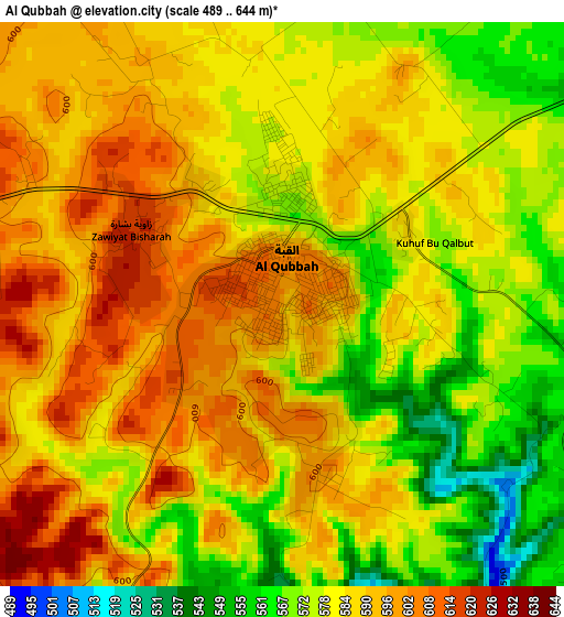
Below is the Elevation map of Al Qubbah, which displays elevation range with different colors. Scale of the first map is from 489 to 644 m (1604 to 2113 ft) with average elevation of 584.8 meters (=1919 ft) [note 1]
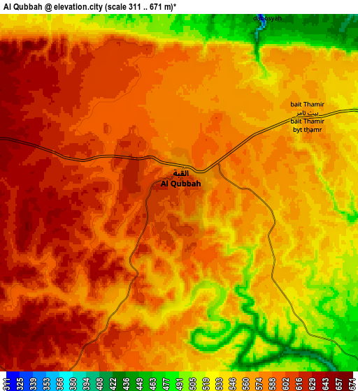
These maps also provides idea of topography and contour of this city, they are displayed at different zoom levels. More info about maps, scale and edge coordinates you can find below images.
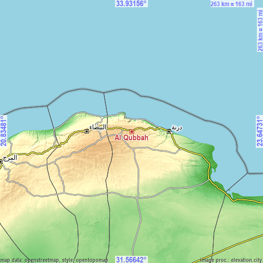
| \ | Map #1 | Map #2 | Topo.Map |
| Scale [m] | 489..644 m | 311..671 m | × |
| Scale [ft] | 1604..2113 ft | 1020..2201 ft | × |
| Average | 584.8 m = 1919 ft | 570.2 m = 1871 ft | × |
| Width | 8.22 km = 5.1 mi | 16.44 km = 10.2 mi | 263 km = 163.4 mi |
| Height | 8.22 km = 5.1 mi | 16.44 km = 10.2 mi | 263 km = 163.4 mi |
| ↑Max Latitude | 32.793789° | 32.830723° | 33.93156° |
| Latitude at center | 32.75684° | 32.75684° | 32.75684° |
| ↓Min Latitude | 32.719875° | 32.682896° | 31.56642° |
| ← Min Longitude | 22.197115° | 22.153169° | 20.83481° |
| Longitude center | 22.24106° | 22.24106° | 22.24106° |
| →Max Longitude | 22.285005° | 22.328951° | 23.64731° |
Nearby cities:
Cities around Al Qubbah sort by population:
• Benghazi elevation 3 m
216 km,  250°
250°
• Ajdabiya 3 m
292.9 km,  220°
220°
• Tobruk 21 m
177 km,  114°
114°
• Al Marj 334 m
135.4 km,  257°
257°
• Darnah 9 m
37 km,  88°
88°
• Al Bayḑā’ 631 m
45.4 km,  270°
270°
• Al Abyār 289 m
166.6 km, 247°
• Tūkrah 16 m
157.6 km, 260°
• Az Zuwaytīnah 7 m
283.5 km, 224°
• Qaryat Sulūq 55 m
222.8 km,  237°
237°
• Al Burayqah 5 m
363.5 km, 224°
• Al Bardīyah 92 m
289.8 km, 112°
Multilingual:
 En español:
Al Qubbah elevación 614 m.
 En France:
Al Qubbah élévation 614 m.
 Auf Deutsch:
Al Qubbah höhe über dem Meeresspiegel ist 614 m.

Sources and notes:
- [note 1] Map square and city borders are not equal. Map elevation data is calculated only from area inside that square.
- [src 1] Elevation data from geonames database provided with same terms of usage.
- [src 2] The elevation map of Al Qubbah is generated using elevation data from NASA's 3 arcsec (90m) resolution SRTM data.
- [src 3] Base (background) map © OpenStreetMap contributors tiles are generated by Geofabrik and OpenTopoMap.
Copyright & License:
This Al Qubbah Elevation Map is licensed under CC BY-SA. You may reuse any part from this page, if you give a proper credit by linking to this URL:
 More info on terms of use page.