Yafran elevation
Yafran (Jabal al Gharbi), Libya elevation is 681 meters and Yafran elevation in feet is 2234 ft above sea level [src 1]. Yafran is a populated place (feature code) with elevation that is 449 meters (1473 ft) bigger than average city elevation in Libya.
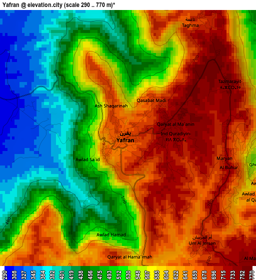
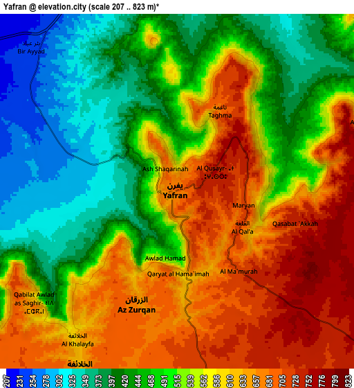
Below is the Elevation map of Yafran, which displays elevation range with different colors. Scale of the first map is from 290 to 770 m (951 to 2526 ft) with average elevation of 566.1 meters (=1857 ft) [note 1]
These maps also provides idea of topography and contour of this city, they are displayed at different zoom levels. More info about maps, scale and edge coordinates you can find below images.
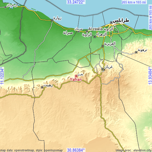
| \ | Map #1 | Map #2 | Topo.Map |
| Scale [m] | 290..770 m | 207..823 m | × |
| Scale [ft] | 951..2526 ft | 679..2700 ft | × |
| Average | 566.1 m = 1857 ft | 534.9 m = 1755 ft | × |
| Width | 8.28 km = 5.1 mi | 16.56 km = 10.3 mi | 265 km = 164.7 mi |
| Height | 8.28 km = 5.1 mi | 16.56 km = 10.3 mi | 265 km = 164.7 mi |
| ↑Max Latitude | 32.100524° | 32.137744° | 33.24722° |
| Latitude at center | 32.06329° | 32.06329° | 32.06329° |
| ↓Min Latitude | 32.02604° | 31.988776° | 30.86384° |
| ← Min Longitude | 12.484645° | 12.440699° | 11.12234° |
| Longitude center | 12.52859° | 12.52859° | 12.52859° |
| →Max Longitude | 12.572535° | 12.616481° | 13.93484° |
Nearby cities:
Cities around Yafran sort by population:
• Tripoli elevation 7 m
110.5 km,  33°
33°
• Az Zāwīyah 18 m
79.4 km,  13°
13°
• Zawiya 21 m
78.9 km, 13°
• Al Ajaylat 19 m
78.5 km,  349°
349°
• Şabrātah 17 m
81.3 km,  357°
357°
• Gharyan 704 m
47.9 km,  75°
75°
• Zuwārah 5 m
105.2 km,  336°
336°
• Zintan 700 m
29.8 km,  240°
240°
• Mizdah 458 m
80.8 km,  147°
147°
• Şurmān 8 m
77.2 km,  2°
2°
• Giado 693 m
48.6 km,  255°
255°
• Al ‘Azīzīyah 116 m
69.5 km,  41°
41°
Multilingual:
 En español:
Yafran elevación 681 m.
 En France:
Yafran élévation 681 m.


Sources and notes:
- [note 1] Map square and city borders are not equal. Map elevation data is calculated only from area inside that square.
- [src 1] Elevation data from geonames database provided with same terms of usage.
- [src 2] The elevation map of Yafran is generated using elevation data from NASA's 3 arcsec (90m) resolution SRTM data.
- [src 3] Base (background) map © OpenStreetMap contributors tiles are generated by Geofabrik and OpenTopoMap.
Copyright & License:
This Yafran Elevation Map is licensed under CC BY-SA. You may reuse any part from this page, if you give a proper credit by linking to this URL:
 More info on terms of use page.