Aizkraukle elevation
Aizkraukle (Aizkraukles novads), Latvia elevation is 88 meters and Aizkraukle elevation in feet is 289 ft above sea level [src 1]. Aizkraukle is a seat of a first-order administrative division (feature code) with elevation that is 22 meters (72 ft) bigger than average city elevation in Latvia.
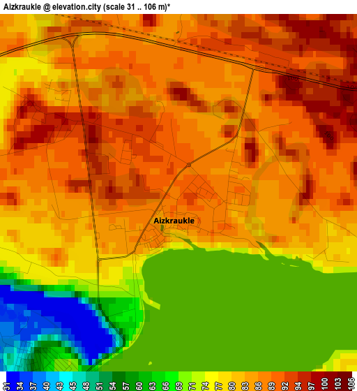
Below is the Elevation map of Aizkraukle, which displays elevation range with different colors. Scale of the first map is from 31 to 106 m (102 to 348 ft) with average elevation of 80.9 meters (=265 ft) [note 1]
These maps also provides idea of topography and contour of this city, they are displayed at different zoom levels. More info about maps, scale and edge coordinates you can find below images.
| \ | Map #1 | Map #2 | Topo.Map |
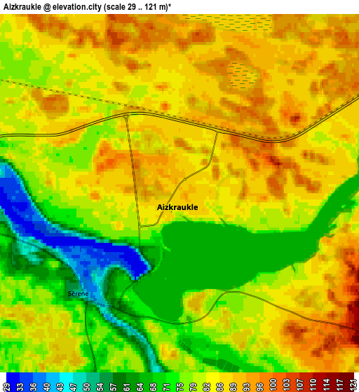
| Scale [m] | 31..106 m | 29..121 m | × |
| Scale [ft] | 102..348 ft | 95..397 ft | × |
| Average | 80.9 m = 265 ft | 81.7 m = 268 ft | × |
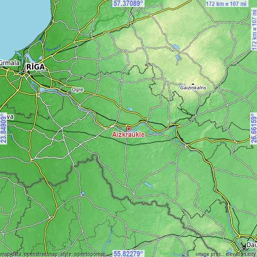
| Width | 5.38 km = 3.3 mi | 10.76 km = 6.7 mi | 172.1 km = 106.9 mi |
| Height | 5.38 km = 3.3 mi | 10.76 km = 6.7 mi | 172.1 km = 106.9 mi |
| ↑Max Latitude | 56.62895° | 56.653115° | 57.37089° |
| Latitude at center | 56.60477° | 56.60477° | 56.60477° |
| ↓Min Latitude | 56.580574° | 56.556363° | 55.82279° |
| ← Min Longitude | 25.211395° | 25.167449° | 23.84909° |
| Longitude center | 25.25534° | 25.25534° | 25.25534° |
| →Max Longitude | 25.299285° | 25.343231° | 26.66159° |
Nearby cities:
Cities around Aizkraukle sort by population:
• Jēkabpils elevation 83 m
38.7 km,  107°
107°
• Krustpils 91 m
38.6 km, 105°
• Lielvārde 47 m
30.3 km,  295°
295°
• Pļaviņas 75 m
28.8 km,  87°
87°
• Skrīveri 77 m
9.4 km, 298°
• Ķegums 41 m
36 km, 295°
• Ērgļi 171 m
40 km,  35°
35°
• Jumprava 70 m
19 km,  294°
294°
• Viesīte 117 m
34 km,  147°
147°
• Jaunjelgava 44 m
10.6 km,  275°
275°
• Sala 83 m
33 km, 109°
• Koknese 86 m
12.2 km,  64°
64°
Multilingual:
 En español:
Aizkraukle elevación 88 m.
 En France:
Aizkraukle élévation 88 m.
 Auf Deutsch:
Aizkraukle höhe über dem Meeresspiegel ist 88 m.

Sources and notes:
- [note 1] Map square and city borders are not equal. Map elevation data is calculated only from area inside that square.
- [src 1] Elevation data from geonames database provided with same terms of usage.
- [src 2] The elevation map of Aizkraukle is generated using elevation data from NASA's 3 arcsec (90m) resolution SRTM data.
- [src 3] Base (background) map © OpenStreetMap contributors tiles are generated by Geofabrik and OpenTopoMap.
Copyright & License:
This Aizkraukle Elevation Map is licensed under CC BY-SA. You may reuse any part from this page, if you give a proper credit by linking to this URL:
 More info on terms of use page.