Madona elevation
Madona (Madona Municipality), Latvia elevation is 149 meters and Madona elevation in feet is 489 ft above sea level [src 1]. Madona is a seat of a first-order administrative division (feature code) with elevation that is 83 meters (272 ft) bigger than average city elevation in Latvia.
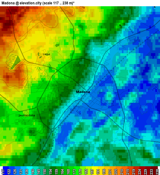
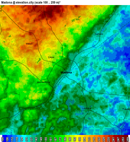
Below is the Elevation map of Madona, which displays elevation range with different colors. Scale of the first map is from 117 to 238 m (384 to 781 ft) with average elevation of 158.3 meters (=519 ft) [note 1]
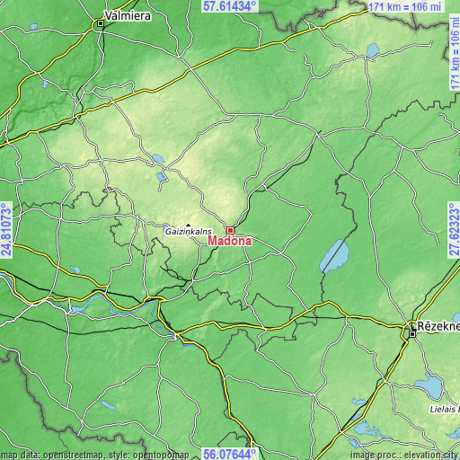
These maps also provides idea of topography and contour of this city, they are displayed at different zoom levels. More info about maps, scale and edge coordinates you can find below images.
| \ | Map #1 | Map #2 | Topo.Map |
| Scale [m] | 117..238 m | 100..259 m | × |
| Scale [ft] | 384..781 ft | 328..850 ft | × |
| Average | 158.3 m = 519 ft | 163 m = 535 ft | × |
| Width | 5.34 km = 3.3 mi | 10.69 km = 6.6 mi | 171 km = 106.3 mi |
| Height | 5.34 km = 3.3 mi | 10.69 km = 6.6 mi | 171 km = 106.3 mi |
| ↑Max Latitude | 56.877311° | 56.901316° | 57.61434° |
| Latitude at center | 56.85329° | 56.85329° | 56.85329° |
| ↓Min Latitude | 56.829254° | 56.805202° | 56.07644° |
| ← Min Longitude | 26.173035° | 26.129089° | 24.81073° |
| Longitude center | 26.21698° | 26.21698° | 26.21698° |
| →Max Longitude | 26.260925° | 26.304871° | 27.62323° |
Nearby cities:
Cities around Madona sort by population:
• Jēkabpils elevation 83 m
45.1 km,  209°
209°
• Gulbene 120 m
48.5 km,  41°
41°
• Krustpils 91 m
43.9 km, 209°
• Pļaviņas 75 m
39.8 km,  228°
228°
• Ērgļi 171 m
35.6 km,  277°
277°
• Varakļāni 100 m
42.6 km,  129°
129°
• Lubāna 95 m
30.8 km,  79°
79°
• Cesvaine 166 m
13.8 km,  23°
23°
• Vecpiebalga 212 m
33.5 km,  313°
313°
• Koknese 86 m
52.6 km,  244°
244°
• Sala 83 m
47.4 km,  215°
215°
• Jaunpiebalga 161 m
37.8 km,  342°
342°
Multilingual:
 En español:
Madona elevación 149 m.
 En France:
Madona élévation 149 m.


Sources and notes:
- [note 1] Map square and city borders are not equal. Map elevation data is calculated only from area inside that square.
- [src 1] Elevation data from geonames database provided with same terms of usage.
- [src 2] The elevation map of Madona is generated using elevation data from NASA's 3 arcsec (90m) resolution SRTM data.
- [src 3] Base (background) map © OpenStreetMap contributors tiles are generated by Geofabrik and OpenTopoMap.
Copyright & License:
This Madona Elevation Map is licensed under CC BY-SA. You may reuse any part from this page, if you give a proper credit by linking to this URL:
 More info on terms of use page.