Ogre elevation
Ogre, Latvia elevation is 21 meters and Ogre elevation in feet is 69 ft above sea level [src 1]. Ogre is a seat of a first-order administrative division (feature code) with elevation that is 45 meters (148 ft) smaller than average city elevation in Latvia.
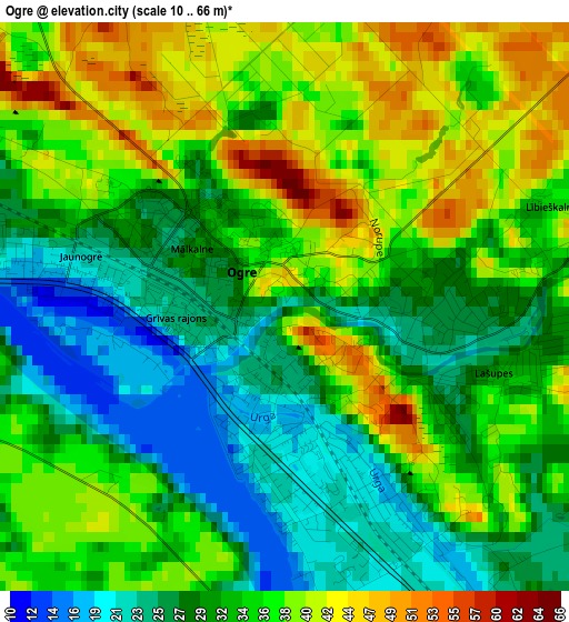
Below is the Elevation map of Ogre, which displays elevation range with different colors. Scale of the first map is from 10 to 66 m (33 to 217 ft) with average elevation of 33.5 meters (=110 ft) [note 1]
These maps also provides idea of topography and contour of this city, they are displayed at different zoom levels. More info about maps, scale and edge coordinates you can find below images.
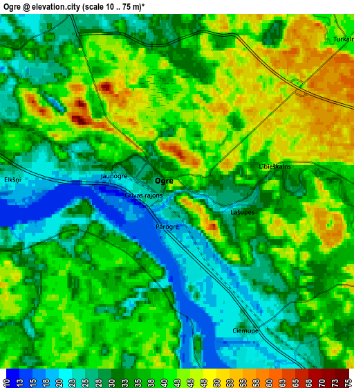
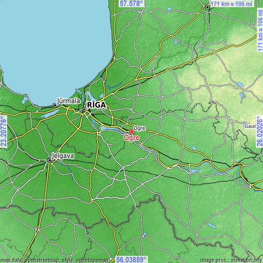
| \ | Map #1 | Map #2 | Topo.Map |
| Scale [m] | 10..66 m | 10..75 m | × |
| Scale [ft] | 33..217 ft | 33..246 ft | × |
| Average | 33.5 m = 110 ft | 35.9 m = 118 ft | × |
| Width | 5.35 km = 3.3 mi | 10.7 km = 6.6 mi | 171.2 km = 106.4 mi |
| Height | 5.35 km = 3.3 mi | 10.7 km = 6.6 mi | 171.1 km = 106.3 mi |
| ↑Max Latitude | 56.840245° | 56.864274° | 57.578° |
| Latitude at center | 56.8162° | 56.8162° | 56.8162° |
| ↓Min Latitude | 56.79214° | 56.768064° | 56.03859° |
| ← Min Longitude | 24.570065° | 24.526119° | 23.20776° |
| Longitude center | 24.61401° | 24.61401° | 24.61401° |
| →Max Longitude | 24.657955° | 24.701901° | 26.02026° |
Nearby cities:
Cities around Ogre sort by population:
• Salaspils elevation 21 m
15.9 km,  287°
287°
• Lielvārde 47 m
15.9 km,  132°
132°
• Ķekava 9 m
23.4 km,  272°
272°
• Ikšķile 36 m
7.4 km, 285°
• Ulbroka 21 m
23.1 km,  305°
305°
• Vecumnieki 35 m
24 km,  193°
193°
• Ķegums 41 m
10.4 km,  139°
139°
• Jumprava 70 m
26.8 km, 125°
• Baldone 44 m
15.2 km,  238°
238°
• Garkalne 12 m
28 km,  335°
335°
• Berģi 14 m
26.9 km, 314°
• Ropaži 43 m
17.7 km,  3°
3°
Multilingual:
 En español:
Ogre elevación 21 m.
 En France:
Ogre élévation 21 m.


Sources and notes:
- [note 1] Map square and city borders are not equal. Map elevation data is calculated only from area inside that square.
- [src 1] Elevation data from geonames database provided with same terms of usage.
- [src 2] The elevation map of Ogre is generated using elevation data from NASA's 3 arcsec (90m) resolution SRTM data.
- [src 3] Base (background) map © OpenStreetMap contributors tiles are generated by Geofabrik and OpenTopoMap.
Copyright & License:
This Ogre Elevation Map is licensed under CC BY-SA. You may reuse any part from this page, if you give a proper credit by linking to this URL:
 More info on terms of use page.